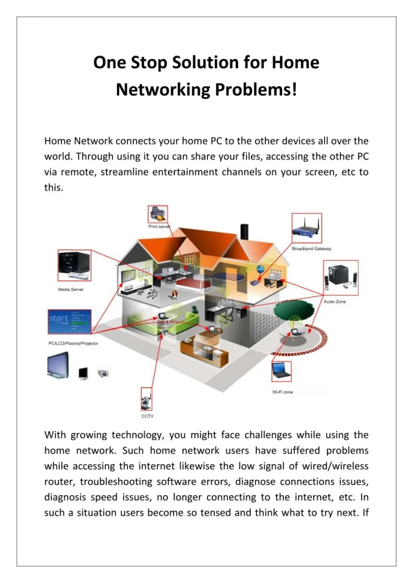
Download
1 / 14
140 likes | 145 Views
This presentation provides an overview of the Space Physics Data Facility (SPDF) and its services for the ViRBO Team. SPDF offers a wide range of data and services related to space physics research, including data translation, orbit information, and multi-mission data. The presentation also highlights the available datasets and capabilities of SPDF's CDAWeb and SSCWeb platforms.

E N D
An Overview of theSpace Physics Data Facility (SPDF) for ViRBO Team Presented 8/31/2007 at GMU[ http://spdf.gsfc.nasa.gov ]
SPDF Home Page - One-Stop for Services Data Translation Services Data and Orbit Services Web Services CDF and Related Software Models Support Pointers to Heliophysics VxOs Feedback Link and Announcements Mailing List
Extensive Multi-Mission Data and Services • CDAWeb includes current data from essentially all (non-solar) current heliophysics missions and experiments since 1990s and some earlier • Functions include plots (gif/ps/pdf), lists, data subsets and file downloads, computed variables • Data available via FTP, user and webservices application interfaces, OPeNDAP • Often add extensive metadata through concept of ”master” CDFs • Webservices and CDAWeb Plus Java interface also support file level access and multi-dataset file retrievals for NSSDC’s currently online (NSSDC ftp site) archival data holdings • SSCWeb offers current/predicted multi-mission orbit data and comparison logic for coordinated science planning and retrospective analysis • Listings, displays, file downloads in many coordinate systems and by regions • Extensive logic to identify s/c-s/c, s/c-region and s/c footpoint - ground station conjunctions • Choice of internal/external field models for tracings • TIPSOD 3-D Orbit Animation Java client based on SSC Webservices (with zoom and field line tracing) • Ongoing updates from projects, NORAD TLEs and other sources • Much faster server in a few months • Host and maintain OMNI hourly and OMNI High-Res (1/5 minute) database of interplanetary parameters mapped to Earth at 1AU (and OMNIWeb services) • Developed and maintain Common Data Format (CDF) • Core s/w library, IDL and MatLab data access routines, CDAWLib library & CDFX program in IDL • Data translation webservices and user i/f, s/w (CDF <-> XML, netCDF, FITS, some HDF) • Draft SPASE-XML description of SPDF and online NSSDC data holdings • CDAWeb holdings to Physical Parameter level
Metrics • We capture system execution (request file/plot/listing) statistics • Survey JGR Space Physics and GRL for acknowledgements (via script) • In 2005 and 2006, ~20% of published JGR Space papers acknowledged SPDF
Select SPDF-Held Data Related to ViRBO • Data and orbit information including • LANL 1989/1990/1991/1994/1997/2001/2002 (SPA, MPA) • NOAA 5/6/7/8/10/12/14 (MEPED) • GOES 6/7/8/9/10/11/12 (EPS, MAG) • THEMIS P1-P5 + GBOs • FAST • CRRES (MEA) • SAMPEX • Wide range of other ITM (TIMED, Alouette/ISIS), magnetospheric (Polar, Geotail, Cluster, IMAGE, Hawkeye, DE) and heliospheric data (ACE, Wind, STEREO, OMNI 1AU multi-s/c) • Additional s/c supported in SSCWeb/TIPSOD database • Newer NOAAs, various DMSP
BACKUP CDAWeb Graphics Examples from TIMED Datasets
TIMED GUVI Data on CDAWeb --- 1 GUVI 1356 A intensities for Oct 20, 2003 10:00-23:00; Mercator projection; Each thumbnail represents one orbit
TIMED GUVI Data on CDAWeb --- 2 North South GUVI 1356 A intensities for Oct 20, 2003 10:00-23:00 North (left) and South (right) Polar projections. Each thumbnail represents one orbit.
TIMED GUVI Data on CDAWeb --- 3 GUVI 1356 A intensities for Oct 20, 2003 19:30-22:00. Along track intensities for all five wavelength bands. GUVI 1356 A intensities for Oct 20, 2003 19:30-22:00. Along track intensities at 7 across-track positions.
TIMED GUVI Data on CDAWeb --- 4 Movie: 1356 A intensities Halloween storm (Oct 29 - Nov 3, 2003)
TIDI wind vector data now available on CDAWeb Transverse Mercator shows both poles and equator in same plot In the form of clickable thumbnails or movies for user-selected time period. Cylindrical projection
SPDF worked closely with the TIMED instrument teams to provide display options for their data that are scientifically interesting and complementary to the ones on their own sites: GUVI: - Cassini projections of airglow intensities showing both poles and equatorial region at the same time (for studying effects of magnetic storms). - Expandable thumbnails of polar plots of intensities. - 14-day movies of intensity images (polar or Cassini) to quickly spot irregularities and study duration of storm effect. - Along-track intensities at several cross-track positions (intensity line plots for study of irregularities). - Nighttime electron density as image and as line plots at various altitudes (studying Equatorial Anomaly). TIDI: - Mapped wind vector plots on different projections at various altitudes separating descending and ascending phase (different Local Times) and warm and cold side of the instrument. - Meridional and Zonal winds at different altitudes (line plots). SABER: - Images of infrared radiances in 10 channels (1.27 to 17ym) from 0 to 150 km (tangent height) and line plots at 80 km. - Images of Mixing Ratios and Volume Emission Rates versus tangent height and also line plots at selected altitudes. SEE: Solar irradiances at several PI-recommended wavelengths and wavelenghts ranges. - Integrated irradiances for several wavelength ranges recommended by the TIMED team.