Download
1 / 26
260 likes | 360 Views
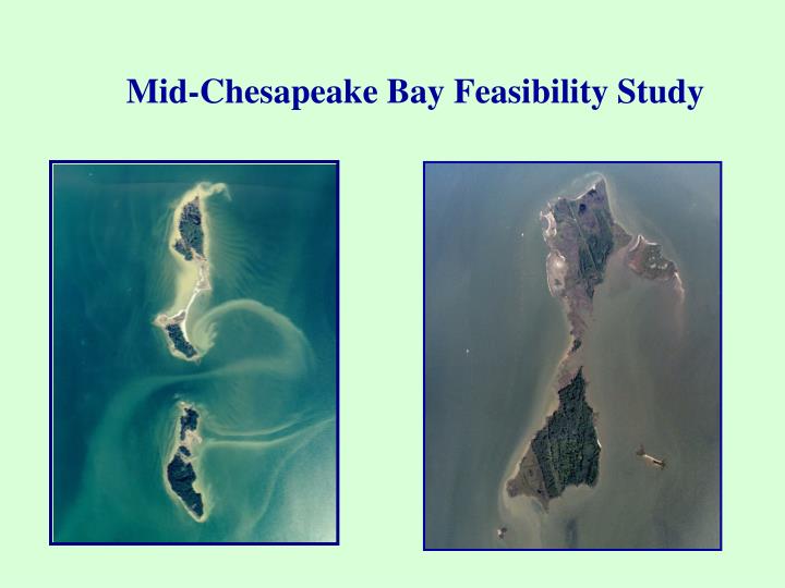
Mid-Chesapeake Bay Feasibility Study. Screening Criteria. Tier I: Island needs to be in study area Tier II: Island needs to be or have historically been at least 200 acres; currently needs to possess the ability to be 200 acres or more

E N D
Screening Criteria • Tier I: Island needs to be in study area • Tier II: • Island needs to be or have historically been at least 200 acres; currently needs to possess the ability to be 200 acres or more • Island must be reasonably accessible for dredged material placement • Island restoration cannot negatively affect the hydraulic conditions of existing river systems • Island cannot significantly impact current navigation of existing waterways • Must be an island/not shoreline
Tier II Continued: • Island must not be a highly populated center • Island must not involve any unexploded ordinance or hazardous, toxic and radioactive waste • If island is currently State or Federally managed as a wildlife area, must have support from the landowners for restoration • Compatibility with any other Corps-led studies being conducted on the island
Barren Island, Dorchester County • Holland Island, Dorchester County • Hoopers Islands, Dorchester County • James Island, Dorchester County • Little Deal Island, Somerset County • Ragged Island, Dorchester County • Smith Island, Somerset County • South Marsh Island, Somerset County
Formulate Alternative Plans • Screen the Island(s) • Collect Detailed Environmental - Engineering - Socioeconomic Data • Prepare Conceptual Plans • Determine Potential Island Configurations/Acreages • No configuration pre-determined • Analyze/Compare Plans • Select Recommended Plan
Corps Six Step Planning Process • Specify Problems and Opportunities • Inventory and Forecast Conditions • Formulate Alternative Plans • Evaluate Effects of Alternative Plans • Compare Alternative Plans • Select Recommended Plan
Site Locations: James and Barren Islands Dorchester County, MD James Island Barren Island
James Island Study FindingsCOASTAL ENGINEERING • Water depths in concept area(s) are 2-12 feet • Highest waves approach from north and south • East side of island sheltered from waves • Longest fetch from south • Currents relatively weak • Maximum velocity 1 ft/sec • Update bathymetric survey Fall 2002
James Island Study FindingsHYDRODYNAMICS & SEDIMENTATION • Minimal impacts on local tidal elevations • Current velocities impacted • Maximum change ±0.4 ft/sec • Beneficial effects on sedimentation rates and patterns • Less shoreline erosion of James Island and portions of Taylors Island • Probable reduction of suspended sediment and improved water quality
James Island Study FindingsEXISTING ENVIRONMENTAL CONDITIONSFall 2001/2002 & Summer 2002 Studies • In situ water quality results were in expected range • Diverse fish community with juveniles of commercially important species • Essential Fish Habitat for 9 finfish species • Bluefish, red drum and summer flounder present • Low B-IBI scores • Average score of 1.6 in Summer 2002
James Island Study FindingsENVIRONMENTAL CONDITIONS (continued) • Variety of wildlife utilizes island remnants • 42 bird species present • 9 species of wildlife • No adverse impacts expected on terrestrial vegetation, including wetlands • Commercial crabbing within concept area will be displaced • Temporary viewshed and noise disturbance during construction • No cultural resources within concept area
James Island Additional Studies • Crab Pot Surveys • April – September • Submerged Aquatic Vegetation (SAV) Survey & Popnetting • Late season grasses • Pound net surveys • Clam Surveys • Soft shell • Razor shell
Barren Island Study FindingsCOASTAL ENGINEERING • Water depths in concept area are 3-10 feet • Highest wind speeds from the southwest and northwest • Longest fetch from the south • Eastern side of island requires less armor because it is sheltered
Barren Island Study FindingsENVIRONMENTAL CONDITIONSFall 2002 & Summer 2002 Studies • In situ water quality results were in expected range • Area inhabited by numerous finfish species • Several species support commercial and recreational fisheries • Essential Fish Habitat for 9 finfish species • Bluefish, summer flounder, and red drum present in area • B-IBI scores were high • Average 3.84 • SAV beds present along eastern shoreline and in quiescent waters east of island • RTE species: bald eagle, royal tern, Wilson’s plover
Barren Island Study FindingsENVIRONMENTAL CONDITIONS (continued) • Two NOBs located in areas adjacent to proposed dike alignment • Island important habitat for colonial waterbirds and wading birds • 61 bird species observed in Summer 2002 • Variety of wildlife utilizes island remnants • 13 species • Reduction of commercial crabbing area • Negligible noise and viewshed disturbance • MHT- no records of historically significant sites
Barren Island Additional Studies • Crab Pot Surveys • May – September • Submerged Aquatic Vegetation (SAV) Survey & Popnetting • Late season grasses • Pound net surveys • Clam Surveys • Soft shell • Razor shell
Plan Formulation • Goal • The goal for this feasibility study is to restore and protect valuable but threatened Mid-Chesapeake Bay island ecosystems through the beneficial use of dredged material.
Plan Formulation • Objectives • Restore and enhance wetland, aquatic and terrestrial island habitat for fish, reptiles, amphibians, birds, and mammals; • Protect existing island ecosystems, including sheltered embayments; • Minimize impacts to fisheries nursery-, feeding-, and protective-habitats; • Increase wetlands acreage in the Chesapeake Bay watershed; • Decrease turbidity and shoreline erosion;
Plan Formulation • Objectives (continued) • Promote conditions that promote the establishment and protection of submerged aquatic vegetation; • Promote conditions that support oyster recolonization; • Minimize impacts to rare, threatened and endangered species and their habitats • Minimize establishment of invasive species; and • Allow for placement of 2 millioncubic yars/year of dredge material.
Plan Formulation • Design Criteria and Constraints • Must protect existing island habitat • Dredge placement depths will be considered in the range of 7-9 feet. • Footprint should be based on geomorphology (i.e. clay areas) • Dike heights need to be at a minimum of 10-12 feet above MLLW.