Download
1 / 19
190 likes | 208 Views
Hydrodynamics and sediment transport processes in the Passaic River Estuary. Robert J. Chant & David Fugate* IMCS Rutgers University * Now at Gulf Coast University Florida October 13 th 2006 Funded by New Jersey Department of Transportation marine.rutgers.edu/cool/passaic

E N D
Hydrodynamics and sediment transport processes in the Passaic River Estuary. Robert J. Chant & David Fugate* IMCS Rutgers University * Now at Gulf Coast University Florida October 13th 2006 Funded by New Jersey Department of Transportation marine.rutgers.edu/cool/passaic Collaborator: Tim Wilson USGS
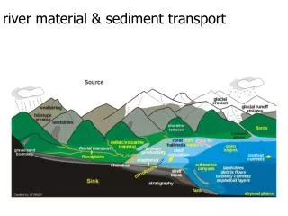
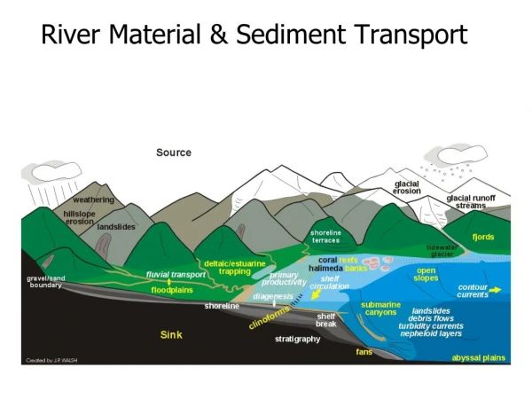
River Ocean EstuarineCirculation What is the structure of Salt field and how does it respond to variations in river flow? What is the magnitude, sign and nature of sediment transport processes and their relationship to river flow? Channel has been highly depositional in past 60 years. Is it still? Need to know answers for predictive modeling of transport of sediment and contaminants and predict future changes.
Catalogs early surveys and Proposed improvements. Recent ebay purchase 1881 chart of lower Passaic.
Our survey 2004-2005 Mooring Locations
Passaic River Mooring Deployments Discharge Little Falls m3/s Tidal Range m
Newark Bay Passaic Low Flow g/l Passaic Newark Bay High Flow g/l
April 5th 2005– Largest discharge event in over 20 years Note discharge of sediment to Newark Bay both in surface layer and at depth.
Q=100 m3/s TSS 100 mg/l Tidal Pumping Augments TSS transport from mean flow! 50 mg/l Q=5 m3/s 0 mg/l
River Flow at Little Falls Suspended Sediment Flux MT/DAY ~30,000 MT/YEAR ..but underestimates big events.
Upstream position of Salt wedge from Shipboard Surveys Small Sediment Transport Large Sediment Transport 25% of the time X2=12*Q-0.28 Newark Harrison Reach
So this means…………. • Sediment transport is dominated by flow events exceeding ~ 50 m3/s • with net downstream sediment transport. • 2) During these times the salt front is downstream of the • Harrison Reach and estimates of net sediment flux is similar to inputs. • 3) Implies that sediment trapping is limited in Harrison Reach BUT.. …geochemical data (Huntely et al. 1995)? suggests that Harrison reach is highly depositional ..geochemical data tells the history– maybe channel is near equilibrium depth?
1845 Chart of New York Bay and Harbor. Thanks to Rutgers Library Special collection and Marc Mappen.
Depths referenced to low Water during spring tide Conditions on Oct 23, 1835 Which were ~ 1 foot lower than MLW.
KVK Passaic River Fresh Salt Channel Depths from 1834 survey (adjusted to MLW)
The Big Passaic Dig 1880-1940 Passaic River Newark Bay
Newark Bay Passaic River Fresh 1940 Salt Fresh 1835 Salt
Leading to an accretion of sediment from upstream towards Newark Bay (arrow) over past 50+ years ….approaching equilibrium.
Conclusions • Sediment transport in Passaic River is dominated by • high flow events. • 2) These events are likely to be associated both with the • input of new (clean?) sediment and resuspension of • bottom sediments. • 3) These large events occur at discharges greater than • 50 m3/s. This occurs ~ 25 % of the time. • 4) While the lower Passaic has been highly depositional • since 1940– the channel is approaching its equilibrium • depth and future accretion will be limited. • 5) Role of deep holes in contaminant transport?