Download
1 / 21
210 likes | 378 Views
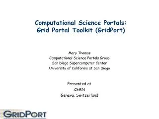
GIS Portal Toolkit 9.3. Marten Hogeweg. Services Architecture. Evolving Spatial Data Infrastructures. GIS Portals. Service Oriented Focus on Content Integration in Business Process. Clearinghouses. Application focus IT standards Interoperable. System-oriented Data focus

E N D
GIS Portal Toolkit 9.3 Marten Hogeweg
Services Architecture Evolving Spatial Data Infrastructures GIS Portals • Service Oriented • Focus on Content • Integration in Business Process Clearinghouses • Application focus • IT standards • Interoperable • System-oriented • Data focus • Geo-standards • Top down File Transfer • Ad hoc • Data focus • FTP transfer • Bottom up
Desktop GIS Lightweight 2-D & 3-D “Science Viewers” OGC Compliant Use Environment Custom Applications GIS Portals Thesaurus Services Authentication Services 3-D Base Map Extraction Services 2-D Base Map Catalog Services Development API SOAP/REST Geo- processing Services OGC Services Tracking Services Location Services GIS Data GIS Data Metadata GIS Data Places Addresses Data Streams Supporting Services Geospatial Web Services Platform Catalog Data Warehouse Services Architecture for SDI • CS-W • UDDI • Service Monitoring • … • Server Caching • High Performance • Thematic Base Maps • Integrated content • … • Derive elevation • Query National Grid • Derive Elevation Profile • Delineate Watershed Boundary • Avian Flue Cluster Analysis • Earthquake Prediction • Hurricane Path Prediction • … • ArcXML, KML • WMS, WFS, WCSOpenLS • REST, SOAP • … • Authentication • Access Control • Thesaurus
SDI Come in Flavors • National SDI • US NSDI, EU INSPIRE, Group on Earth Observation, WALIS SLIP • Federated catalogs with 10,000 to 100,000+ items • Clearinghouses • Arkansas, Mississippi, Alabama, Kentucky, Croatia, Lithuania, … • Often act as focal site for data distribution • Enterprise SDI • USGS, NATO, US EPA, BHP Billiton… • Focus: • Data Collection, Geospatial information products and services, Cataloging and Discovery, Product Generation, Product Delivery • Integrate in Enterprise Service Architectures
Some Components of SDI Serve Discover Use Author Visualization Production Workflow Services Tasking Products and Services Program Analysis End Users Mission Critical Applications Data Collection
What is the GIS Portal Toolkit? • Purpose: Enable Discovery and Use of Geospatial Resources • Enables you to build a GIS Portal with the following capabilities: • Searching and viewing metadata • Viewing live map services • Publishing metadata • Storing metadata • Downloading Data • Managing metadata • Harvesting
CatalogService GIS Portal Components Map Viewer GIS Portal Site Starter Content ManagementSystem (3rd Party) REST API GeoRSS/KML ArcMap Java ADF ArcGIS Explorer Harvesting Service
What’s New in GPT 9.3 Completely Rewritten and New Architecture Use of GPT with ArcGIS Server ADF-based Map Viewer Harvesting Enhancements New Security Framework Expanded Data Download Capabilities Extensible Metadata Profile Support OGC CSW Search Task REST API for Metadata Discovery Integrate with External Content Management System
ArcGIS Server-based GIS Portal • ArcGIS Server provides: • Search Map Service • Place Finder Service • Address Finder Service • Projection Service • Data Download Service • Stand-alone Metadata Service provides: • Metadata publishing • OGC CS-W Interface • User Experience: • Updated GUI • Context-sensitive Help
ADF-based Map Viewer • Shared platform across solution products • Highly customizable through ADF template • Interoperability Support • OGC WMS/WCS/WFS • GeoRSS • ArcGIS Server • ArcIMS
Harvesting Enhancements Additional OGC CSW Application Profiles Harvest ArcGIS Server content Treat harvested metadata as a collection User-initiated harvest Harvesting service automates harvesting Synchronize content
Publishing Client for ArcCatalog • One-click publishing • Publishes Metadata for ArcCatalog Items • Recurses into workspaces and geodatabases • Written in Python Extensible
Security Framework ArcCatalog Simple LDAP GPT Servlet Connector Authentication Service Metadata Service Permissions Metadata Service • Authenticate users with LDAP: • Apache Directory Server • Sun Directory Server • Microsoft Active Directory • IBM Tivoli Access Manager • Oracle CoreID • Integration with existing authentication services • ArcCatalog authenticates with LDAP • OR: Simple Configuration with a single authenticated administrator
Expanded Data Download Capabilities • Based on project experience • Use ArcGIS Server Geoprocessing Task • REST/SOAP Service • Written in Python • Customizable
Extensible Metadata Profile Support • Support new metadata profiles based on ISO 19139 • INSPIRE, North American Profile, ANZLIC, Earth Observation Profile, NATO • Support simple metadata creation process (Dublin Core) • Simplify validation • Extensible Framework for Metadata Standard Support: • Includes: Sections and subsections, Conditional Mandatory Elements, Different input elements, Read-only elements, Default values, Localization, and Namespaces • Publishing Process: • Validation • Transformation
OGC CSW Search Task ArcGIS Explorer GUI Java ADF GUI ArcMap GUI Search Task CS-W Client CS-W Service • Search Task for ArcMap, ArcGIS Explorer and ADF • Search CS-W Catalogs • View Metadata Footprints • Add to Map/Globe • Common Architecture • Common User Experience
GPT 9.3 – REST API REST API for querying Metadata Catalog GeoRSS feed (RSS 2.0) Supports OpenSearch
Integrate with External Content Management System (CMS) • Custom Configuration • Using REST API to Render HTML snippets • Develop plug-ins for CMS or wiki • Configure Authentication and Single Sign-on • Integrate in Enterprise Architectures Joomla! JSPWiki
GPT 9.3 – Enhanced Documentation Installation and Migration Guides CSW Clients User Guide Harvesting Tool User Guide Metadata Editor Customization Guide GPT Customization Guide Localization Guide Database Documentation Javadoc for Developers
Where To Go From Here? • Visit http://www.esri.com/gisportal • E-mail to: portal@esri.com • Visit the GIS Portal Toolkit Discussion Forum: http://forums.esri.com/Forums.asp?c=156 • ESRI Support page: http://support.esri.com