Download
1 / 25
250 likes | 482 Views
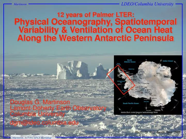
12 years of Palmer LTER: Physical Oceanography, Spatiotemporal Variability & Ventilation of Ocean Heat Along the Western Antarctic Peninsula. LDEO/Columbia University. Martinson. Douglas G. Martinson Lamont-Doherty Earth Observatory Columbia University dgm@ldeo.columbia.edu.

E N D
12 years of Palmer LTER: Physical Oceanography, Spatiotemporal Variability & Ventilation of Ocean Heat Along the Western Antarctic Peninsula LDEO/Columbia University Martinson Douglas G. Martinson Lamont-Doherty Earth Observatory Columbia University dgm@ldeo.columbia.edu mstecker.com/pages/antsatmap.htm Photo: Dr. R.C. Smith, Sep. 2001 Martinson, 5/15/05; APCV Workshop
An. B. - A. -60 Bellingshausen Sea Ad. Sample region Location Map & Grid R. COAST L. SHELF SLOPE M.B.
SLOPE SHELF COAST Background SHELF SLOPE COAST Bathymetric Shading: White ≥ 750 m 750 > light-grey ≥450 m Dark-grey < 450 m
0.107˚ C/year Significant at 0.05 ~5.4x global average Motivation • Western Antarctic Peninsula • Most rapid recent regional winter warming on Earth • Major loss of perennial sea ice • 87% of glaciers are in retreat Vaughan et al., 2003 Perennial Ice Stammerjohn et al., 2006 Cook et al., 2005
PAL LTER Grid (1992-2004) WOCE SP04: WAP ACC (February 1992) NBP94-04: Bellingshausen Slope (March 1994) Major global volumetric modes 3.5–4˚C #31 #33 #51 #55 #59 Source of heat Source of Winter Heat 34.75 34.54 2.13˚ ACC-core UCDW 1.70˚ ANTARCTIC (summer) SURFACE WATERS (AASW) WW
Antarctic Circumpolar Current Antarctic Circumpolar Current SHELF wAP is unique as only location with ACC directly adjacent to shelf COAST SLOPE Proximity of ACC The Southern Ocean PAL LTER Sampling Grid Bellingshausen Sea Weddell gyre Bellingshausen Sea Amundsen Sea Ross gyre
1993-2004 climatology NC – SC – MA + OA + Delivery of UCDW r[z(max), Dynamic Topo] r Individual years consistent with drifter data (our only absolute velocity obs) UCDW pulled onto shelf by upwelling dynamics (likely wind-driven)
F w CO2 Uptake r, S summer T summer Biology Tf, S, r Tf, S, r winter winter CO2, PO, etc. CO2, PO, etc. CO2 Venting TD, SD, rD TD, SD, rD CO2D, POD, etc. CO2D, POD, etc. Shelf heat flux Seasonal Cycle Martinson and Takahashi, in prep
<FTBP>W = 29.67 Wm2 (Martinson & Iannuzzi, 1998) <FTObs>W = 27.7 Wm2 (McPhee et al., 1999) Shelf heat flux FT: Bulk Parameter vs Measured (AnzFlux, 1994)
FET/FDT FT Shelf heat flux Bulk heat flux and Entrainment/diffusive heat flux ratio W/m2
Temperature (˚C) Shelf heat flux Slope (~20 km off-shelf) Temperature Qslope Depth (db) Temperature section 2000 2001 Depth (db) 2002 2003 Grid line Grid line
FT variability 1998 Grid-wide Regime Shift(ubiquitous across physical properties) Temperature of max SDw Equivalent ice thickness (m)
FT variability Modes of ocean heat flux
Ocean heat flux (FT) to atmosphere over WAP shelf • shows considerable change in latter part of 1900s • (coinciding with increased Tair and glacial melt): • Large step increase in 1990 (+4 Wm-2) • Qshelf & Qslope are proxies for FT • FT shows jump in 1998 by 3 Wm-2 followed by same jump each year thereafter FT variability Contribution to sea level rise and peninsula warming: ocean heat flux
WAP region dominated by circumpolar water masses ACC/UCDW water along slope delivering heat and nutrients to WAP continental shelf UCDW floods shelf from dynamical forcing (likely wind driven upwelling) Slope waters enter via canyons in shelf, eventually flood onto shelf floor WAP bathymetry controls property distributions and stratification T–S plot shapes reflect sub-regions and indication of time since renewal Extreme El Niño of 1998 introduced grid-wise regime shift Apparent in all physical variables Ocean heat flux temporal increases on shelf are consistent with strong atmospheric warming and dramatic glacial melt on WAP Can continue increasing to what level before internal adjustments regulate? Conclusions: Future: • Determine WAP glacial melt and commensurate freshwater input • Secure funding for moorings to evaluate UCDW flooding episodes • Monitor excess heat supply from eddies, or other episodic flooding events and tie these events to large scale (satellite observable) mechanistic causes
^ Shelf heat flux <Kz> m2/s x10-4 m2/s x10-4 Grid Line (km) Grid Station (km) Grid Station (km)
Salinity Shelf heat flux Salt Deficit (SDw) Thermal Barrier (TBw) FDT = kzcpT (diffusive heat flux) = TBw + SDw (bulk stability) FET = (TBw/)FL (entrainment heat flux) FL = (Fair - FDT) (latent heat flux) FT = FDT + FET (total heat flux) Temperature (˚C) Martinson and Iannuzzi, JGR, 1998
1993-2004 climatology NC – SC – MA + OA + Delivery to shelf r[z(max), Dynamic Topo] r
Delivery to shelf Note: water enters shelf through canyons, consistent with dynamic topo. C.
Delivery to shelf Cross-shelf T-anomalies
FT variability Lines 150-650 (average Q-shelf) r = 0.75 Qshelf (x109 J/m2) FT Wm-2
~0.7˚ C warming of 300 m column of water below winter mixed layer (+4 W/m2 increased FT for same Qshelf) FT variability 1990–2004 Average Qslope = (3.83 ± 0.07 )x109 Qslope (x109 J/m2) 1930–1989 Mean Qslope = (2.98 ± 0.16)x109 rms about NUMBER OF PROFILES PER AVERAGE YEAR
FT variability Lines 150-650 (full shelf and coast stations) All shelf stations Qshelf (x109 J/m2) Year
The Antarctic Dipole (of which Palmer Station lies at the node point), is the largest response to ENSO events outside of the tropics, displaying a strong tropical-polar teleconnection. It is a major Southern Ocean polar climate mode. It shows a dipole whereby during an El Niño the Weddell gyre is spun up, and becomes colder with more sea ice, while the Amundsen Sea shows the opposite. For La Niña, the opposite relationship is seen. Two mechanisms are responsible for the formation & maintenance of the Antarctic Dipole: (1) heat fluxes due to the mean meridional circulation of regional Ferrel Cell and (2) anomalous high-pressure center generated by stationary eddies. The changes in the Hadley Cell, the jet stream, and the Rossby Wave train, all associated with El Niño, link the tropical forcing to these high latitude processes.