Download
1 / 8
90 likes | 211 Views
Industrial Products Division Measurement & Control Space & Atmospheric Division Environmental Monitoring Imaging Division ILRIS-3D Terrestrial Survey Division Terrestrial Surveying Marine Survey Division Hydrographic Surveying. Stennis. Stennis. Stennis.

E N D
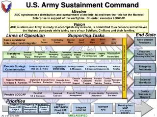
Industrial Products Division Measurement & Control Space & Atmospheric Division Environmental Monitoring Imaging Division ILRIS-3D Terrestrial Survey Division Terrestrial Surveying Marine Survey Division Hydrographic Surveying Stennis Stennis Stennis Lines of Business
Terrestrial Survey - Airborne Laser Terrain Mapper (ALTM) • Terrain mapping system for rapid digital elevation data • 40 systems worldwide • 10 new systems annually
Marine Survey Airborne Laser Bathymetric Surveying SHOALS 1000 Scanning Hydrographic Operational Airborne Laser Survey Integrated, self-contained, laser-based, swath surveying system for shallow (<50 m depth) coastal water mapping
Marine Survey • Built by Optech • Delivered to USACE in 1994 • Presently operated by government consortia (Army/Navy)
The Next Generation Compact Hydrographic Airborne Rapid Total Survey (CHARTS) • Built by Optech – deliver to Navy in 2003 • Total Coastal Mapping System – shallow water and nearshore • SHOALS 1000 bathymetric system • Topographic system • Digital Camera • Smaller profile and weight • Platforms of Opportunity