Download
1 / 1
10 likes | 169 Views
13th EMS Annual Meeting & 11th European Conference on Applications of Meteorology (ECAM) | 09 – 13 September 2013 | Reading, United Kingdom. Effects of regional climate model spatial resolution on 10m wind field over the Aegean Sea

E N D
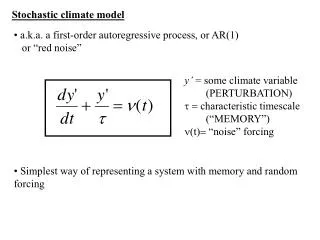
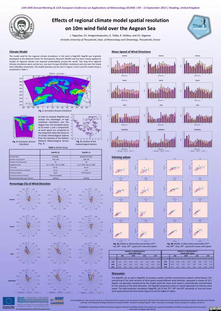
13th EMS Annual Meeting & 11th European Conference on Applications of Meteorology (ECAM) | 09 – 13 September 2013 | Reading, United Kingdom Effects of regional climate model spatial resolution on 10m wind field over the Aegean Sea I. Tegoulias, Ch. Anagnostopoulou, K. Tolika, K. Velikou, and Ch. Vagenas Aristotle University of Thessaloniki, Dept. of Meteorology and Climatology, Thessaloniki, Greece Mean Speed of Wind Directions Climate Model The model used for the regional climate simulations in this work is RegCM3. RegCM was originally developed at the National Center for Atmospheric Research (NCAR) and has been mostly applied to studies of regional climate and seasonal predictability around the world. Two long term regional climate simulations were carried out, one over Europe (25x25km resolution) and one over the Greek Area (10x10km resolution). The model domains can be seen in Figure 1 and 2 and the model setup is presented in Table 1 . Fig. 1: Simulation domain (25x25km) In order to evaluate RegCM3 and analyze the advantages of high resolution simulations over the Aegean Sea, the simulated values of 10 meter u and v components of wind speed are compared to the respective observed values at 15 Greek meteorological stations from the network of the Hellenic National Meteorological Service (Fig. 3). Fig. 2: Simulation domain (10x10km) Fig. 3: Location of the meteorological stations Table 1: Model Setup Extreme values Percentage (%) of Wind Direction Fig. 4a: Model vs Observation percentiles (75th - red, 90th - blue, 95th - green) for max wind speed Fig. 4b: Model vs Observation percentiles (75th - red, 90th - blue, 95th - green) for mean wind speed Discussion The RegCM3_10, as well as RegCM3_25 produce realistic monthly wind direction patterns (Wind Roses). The partitioning of the total variance of wind speed among different wind direction, separated in classes of 22.5 degree, are generally reproduced by the models while the mean wind speed is systematically overestimated for the majority of the wind directions. The RegCM3 projections show an overall agreement to extreme wind speed. The high-resolution simulations (RegCM3_10) of the 75th, 90th and 95th percentile of max and mean wind speed present the best results (Figure 4) and the higher R2 values. Acknowledgments: This research has been co-financed by the European Union (European Social Fund– ESF) and Greek national funds through the Operational Program "Education and Lifelong Learning" of the National Strategic Reference Framework (NSRF) - Research Funding Program: Thalis. Investing in knowledge society through the European Social Fun “CCSEAWAVS: Estimating the effects of Climate Change on SEA level and WAve climate of the Greek seas, coastal Vulnerability and Safety of coastal and marine structures” www.thalis-ccseawavs.web.auth.gr