Download
1 / 55
550 likes | 643 Views
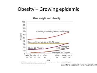
The Geography of Obesity: Mapping and Modeling in King County. Third King County Overweight Prevention Initiative Forum: Activate Friday, October 14, 2005. Phil Hurvitz University of Washington College of Architecture and Urban Planning Urban Form Lab gis.washington.edu/phurvitz.

E N D
The Geography of Obesity: Mapping and Modeling in King County Third King County Overweight Prevention Initiative Forum: Activate Friday, October 14, 2005 Phil Hurvitz University of Washington College of Architecture and Urban Planning Urban Form Lab gis.washington.edu/phurvitz Slide 1 (of 55)
Acknowledgements • Apart from mine, much of this material is drawn from the work of: • Luc deMontigny (PhD student, UW-CAUP) • Lin Lin (PhD student, UW-CAUP) • Anne Vernez Moudon (Professor, UW-CAUP, director of the Urban Form Lab) Slide 2 (of 55)
The Big Picture • Use of geospatial analysis tools can increase our ability to understand spatially-related factors contributing to the obesity epidemic. Slide 3 (of 55)
Outline • Background: GIS, Epidemiology, the Built Environment, Spatial Scale & Unit of Analysis • Current Research from the Urban Form Lab • Walkable-Bikeable Communities Analyst (ArcView GIS Extension for Quantifying the Built Environment) • Fast Food Location Analysis • GIS-Based Spatial Sampling for SES, Behavior, and the Built Environment • Surface Modeling/Interpolation of Walkability Indices Slide 4 (of 55)
Outline • Background: GIS, Epidemiology, the Built Environment, Spatial Scale & Unit of Analysis • Current Research from the Urban Form Lab • Walkable-Bikeable Communities Analyst (ArcView GIS Extension for Quantifying the Built Environment) • Fast Food Location Analysis • GIS-Based Spatial Sampling for SES, Behavior, and the Built Environment • Surface Modeling/Interpolation of Walkability Indices Slide 5 (of 55)
Background: What is GIS? • A computer-based method for • Capture, • Storage, • Manipulation, • Analysis, and • Display of spatially referenced data Slide 6 (of 55)
Background: What is GIS? • Any object or phenomenon that is or can be placed on a map can be stored, managed, and analyzed in a GIS. • Built environment features (streets, buildings, bus routes, restaurants, schools) • Households (address points, tax-lot polygons) • Individuals (points or travel lines/polygons) • Ground surface elevation or slope • Movement of objects through time and/or space Slide 7 (of 55)
Background: Why is GIS Important in Epidemiology? • Epidemiology and public health are interested in population-wide effects • Population-wide effects can only be ascertained from individual-level measurements • GIS allows the measurement of individual characteristics within an explicitly spatial context • If location is an important factor in a public health issue, GIS should be incorporated as a data management and analysis tool Slide 8 (of 55)
Inner personalenvironment Personal/individualfactors = Social/communityenvironmentalfactors Institutional/policyenvironmentalfactors Builtenvironmentalfactors Outerenvironments = + + Intervention – behaviorchange/modification Background: Conceptual Framework for Social Ecologic Model • Social ecologic model considers impacts of environment (institutional, physical, social, etc.) on behavior. (Stokols, 1992; Sallis and Owen 1997) Person(behavior) Slide 9 (of 55)
Background: The Built Environment Matters • Associations between income and built environment • Associations between walking/transit use and built environment • Confounder in studies of behavior and the built environment: Self-selection and causation • Do people move to walkable neighborhoods and then start walking, or do walkers search out walkable neighborhoods? • “We shape our buildings; thereafter they shape us.” -Sir Winston Churchill Slide 11 (of 55)
The Big Picture • We can intervene in these arenas: • Social/Community • Institutional/Policy • Built Environment Slide 10 (of 55)
Background: Comparing Units of Spatial Data Capture, Storage, and Analysis (Tax-lots) • Tax-lot-level data are detailed and varied • Variation at the household-unit population level is maintained and can be used for analytical purposes Slide 12 (of 55)
Background: Comparing Units of Spatial Data Capture, Storage, and Analysis (Tax-lots) Slide 13 (of 55)
Background:Comparing Units of Spatial Data Capture, Storage, and Analysis (Census Tracts) • Census data lack detail and variation • Within-tract variation is lost as geometries become larger and more aggregated Slide 14 (of 55)
Background: Unit of Data Capture & Analysis: Affects Quantitative Output Rank order by value Rank order by value Slide 15 (of 55)
The Big Picture • Epidemiologic data model:To understand what is happening to individuals or households, we need data with resolution at the individual or household level. Slide 16 (of 55)
Outline • Background: GIS, Epidemiology, the Built Environment, Spatial Scale & Unit of Analysis • Current Research from the Urban Form Lab • Walkable-Bikeable Communities Analyst (ArcView GIS Extension for Quantifying the Built Environment) • Fast Food Location Analysis • GIS-Based Spatial Sampling for SES, Behavior, and the Built Environment • Surface Modeling/Interpolation of Walkability Indices Slide 17 (of 55)
The WBC Analyst ArcView GIS Extension • Automates several measurement methods (inventories “what” and “where” of the built environment) • What features are within walking distance to the household? • Land use proportions • Count/length/area of features, e.g., groceries, restaurants, bus stops, streets, sidewalks • How close (distance) are various features? • Grocery stores, restaurants, schools, etc. Slide 18 (of 55)
WBC Analyst: Proximity and Buffer Measures calculates over 200 different built environment variables within user-specified distance of household Slide 19 (of 55)
WBC Analyst: “What” and “Where” Can Explain the Choice to Walk • Output of GIS coupled with telephone survey data • Using multinomial logit we were able to explain 35% of the variation in walking with only socio-demographic variables: • age • education • neighborhood social environment • attitude toward traffic and environmental quality • Adding environmental variables (presence of certain land uses within 1 mile of the home) obtained from the GIS increased the R2 to 47% • Extension is currently being used by researchers in public health, epidemiology, and transportation Slide 20 (of 55)
WBC Analyst: Neighborhood Centers (NCs) • Generates “clusters” from locally aggregated land use tax-lots Slide 21 (of 55)
The Big Picture • Using GIS we can measure and model factors of the built environment that are contributors to obesity. Slide 22 (of 55)
Outline • Background: GIS, Epidemiology, the Built Environment, Spatial Scale & Unit of Analysis • Current Research from the Urban Form Lab • Walkable-Bikeable Communities Analyst (ArcView GIS Extension for Quantifying the Built Environment) • Fast Food Location Analysis • GIS-Based Spatial Sampling for SES, Behavior, and the Built Environment • Surface Modeling/Interpolation of Walkability Indices Slide 23 (of 55)
Example Application: Fast Food Location Analysis • Analysis of location of fast food restaurants • How do the densities and counts of these restaurants vary through space? • Are the differences in densities related to demographic variables? Slide 24 (of 55)
Fast Food Location Analysis: Where Are They? • Fast food restaurant addresses are available free online (Qwest – dexonline.com) • Online telephone directories have regular structure (server-side script generated html) that can be extracted with customized client-side scripts Slide 25 (of 55)
What is in the HTML Fast Food Location Analysis What the user sees Slide 26 (of 55)
Fast Food Location Analysis • Asset mapping: address geocoding places fast food restaurants in spatial framework common with other regional data sets Slide 27 (of 55)
Fast Food Location Analysis • Analysis of locations • Kernel interpolation method • Calculates density of fast food restaurants at all locations across study area Slide 28 (of 55)
Fast Food Location Analysis • Analysis of locations • Count of number of fast food restaurants within 1 mile for all locations Slide 29 (of 55)
Fast Food Location Analysis • Sociodemographic pattern? • Density of fast food restaurants appears higher in block groups with higher poverty levels • Pearson’s Product Momentcorrelation ρ= 0.23, p < 0.005 Slide 30 (of 55)
Fast Food Location Analysis • Sociodemographic pattern? • Mean count of fast food restaurants higher in block groups with higher poverty levels • Pearson’s Product Momentcorrelation ρ= 0.25, p < 0.005 Slide 31 (of 55)
The Big Picture • Fast food restaurants in western King County are located in higher densities within lower income census block groups. Slide 32 (of 55)
Outline • Background: GIS, Epidemiology, the Built Environment, Spatial Scale & Unit of Analysis • Current Research from the Urban Form Lab • Walkable-Bikeable Communities Analyst (ArcView GIS Extension for Quantifying the Built Environment) • Fast Food Location Analysis • GIS-Based Spatial Sampling for SES, Behavior, and the Built Environment • Surface Modeling/Interpolation of Walkability Indices Slide 33 (of 55)
GIS-Based Spatial Sampling for SES, Behavior, and the Built Environment Spatially-based population sampling is of benefit to inferential research using surveys. Our approach: • Ensures sufficient variation in and proper distribution of key variables in the sample(e.g., environmental characteristics such as residential density, proximity to activities, schools) • Ensures adequate occurrences of rare events in the sample(e.g., respondents belonging to racial minorities, those living close to public transit) • Controls for conditions of no interest(e.g., areas of low residential density) Slide 34 (of 55)
Novel approach: Spatial sampling with GIS Method • Use the GIS to spatially stratify population of interest to construct a sample frame. Data can be taken from any GIS database, such as: • Tax-lot data: e.g., land use, assessed property values • Political data: e.g., urban growth boundary • Environmental data: e.g., slope • Census data: e.g., race • Randomly select individual residential units (a proxy for households) from the spatial sample frame. This limits the sample to a spatially and demographically specific population of interest. Slide 35 (of 55)
GIS-Based Spatial Sampling: A Demonstration of the Approach Example of criteria for delimiting a sample frame of a population “At Risk” of obesity: Households that reside: • Farther than 1 mile from a Neighborhood Center cluster of grocery stores and restaurants • In a residential unit in the bottom 1/3 of assessed property value • In a census block with greater racial diversity • Within the King County Urban Growth Boundary Slide 36 (of 55)
> 1 mi from [rest + gro] racially diverse combined sample frame(orange tax-lots) lower 1/3 property value GIS-Based Spatial Sampling: A Demonstration of the Approach Slide 37 (of 55)
Spatial Sampling • Used to generate the sample for households surveyed in the WBC project. • Lee, C, Moudon, AV and Courbois, JP (in press). Built Environment and Behavior: Spatial Sampling Using Parcel Data, The Annals of Epidemiology Slide 38 (of 55)
The Big Picture • Using GIS in designing sampling strategies increases statistical power while limiting the study to a population of interest. Slide 39 (of 55)
Outline • Background: GIS, Epidemiology, the Built Environment, Spatial Scale & Unit of Analysis • Current Research from the Urban Form Lab • Walkable-Bikeable Communities Analyst (ArcView GIS Extension for Quantifying the Built Environment) • Fast Food Location Analysis • GIS-Based Spatial Sampling for SES, Behavior, and the Built Environment • Surface Modeling/Interpolation of Walkability Indices Slide 40 (of 55)
y B A a b x Surface Modeling Process • Measure sample locations • Create interpolated surface • Estimate values at non-sample locations Slide 41 (of 55)
Application of Surface Modeling: Walkable-Bikeable Communities (WBC) Project • Survey of 608 households (spatially sampled) for activity behavior & perception of environment (dependent variables) • Measured built environment characteristics with WBC Analyst Extension in the GIS (independent variables) • Multinomial logistic regression models developed to predict the probability of walking moderately (1-149 min/wk) or sufficiently (>= 150 min/wk) vs. not walking, based on built environment characteristics • Surface modeling (Radial Basis Function) to interpolate walkability values at non-sampled locations Slide 42 (of 55)
WBC Project Sample Household locations randomly sampled from the GIS-derived sample frame Slide 43 (of 55)
(> $75,000) Slide 45 (of 55)
(< $25,000) Slide 46 (of 55)
Likelihood of Sufficient Walking--Age Older Adult (>65 y) Younger Adult (<35 y) Slide 47 (of 55)
Likelihood of Sufficient Walking—Transit Usage Transit User Non-Transit User Slide 48 (of 55)
Environmental Intervention and Assessment Simulation • Change values of environmental variables in regression model to predict new walking probability under different scenarios • New surface interpolation generates “before” and “after” intervention surface models Allows an estimate of the impacts of environmental interventions Slide 49 (of 55)
Add 1 Grocery Store and 1 [Grocery+Restaurant+Retail] NC within 1 km of Home Slide 50 (of 55)