Download
1 / 26
260 likes | 536 Views
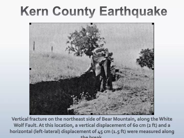
Kern County Earthquake. Vertical fracture on the northeast side of Bear Mountain, along the White Wolf Fault. At this location, a vertical displacement of 60 cm (2 ft) and a horizontal (left-lateral) displacement of 45 cm (1.5 ft) were measured along the break. Vital stats.

E N D
Kern County Earthquake Vertical fracture on the northeast side of Bear Mountain, along the White Wolf Fault. At this location, a vertical displacement of 60 cm (2 ft) and a horizontal (left-lateral) displacement of 45 cm (1.5 ft) were measured along the break.
Vital stats • July 21, 1952, 4:52 am local time • Epicenter 37 km south of Bakersfield, CA • Mw 7.2-7.3 (7.5 in Gutenberg, 1955) • Claimed 12 lives, caused at least $50 million in damage • > 20 aftershocks of Mw 5.0 or greater • Size of earthquake much larger than extent of previously mapped fault trace
Outline • Tectonic Setting • Focal mechanism • Aftershock Distribution • Surface deformation • Ground motion • Fault information: geometry, slip rate, lateral extent • Regional stress state • Triangulation and Leveling data • Relationship to ΔCFS from Fort Tejon
Focal mechanism Left-lateral oblique thrust, two sub-events: SW: deep, pure thrust major subevent NE: shallow, strike slip secondary subevent Consistent with aftershock depth distribution Fault dip: 60-66° (Wallace and Junkyoung, 1989) Figure from Castillo and Zoback, 1995)
Aftershock distribution 1983-1999 seismicity, Castillo and Zoback, JGR, 1995
Field observations of surface deformation Photo: Southern Pacific Railroad A view from the entrance of a railroad tunnel (designated "Tunnel No. 3") showing bent rails between two tunnels near a zone of intense fracturing along the White Wolf fault.
Field observations of surface deformation Photo: Southern Pacific Railroad Inside Tunnel No. 3. A close-up not only of bent rails, but of an unusual phenomenon -- the rail is continuous underneath the tunnel wall, indicating that the wall lifted up enough for the rail to slide underneath.
Ground Motion • Strong asymmetry of ground motion on the hanging wall • Precarious rocks requiring low accelerations (<0.3 g) to topple found <10 km from the fault trace on the hanging wall, unmoved for >1000 years. • Precarious rocks toppled near the fault zone in the footwall and hanging wall • No precarious rocks in hanging wall, shattered bedrock, and landslides indicate enhanced deformation in the hanging wall (Brune et al, BSSA, 1999)
What do we know about the fault? • Geometry (Goodman and Malin, 1992) • Normal motion in the Miocene, depocenter • 2-3 km sediment fill in the Tejon embayment, 7-8 km in the Maricopa subbasin to the north • Reversed motion in the Pliocene • Slip Rate (Stein and Thatcher, 1981) • Measured offset of late quaternary and late Miocene stratigraphic markers indicate slip rate increased from 0.1-0.2 mm/yr to 3-9 mm/yr between past 10-15 my and 0.6-1.2 my • Estimated recurrence interval: 170-450 years • Extension to the northeast into the Scodie Lineament (Bawden et al, 1999)
Fault geometry Constrained by field, borehole, and seismic data (Goodman and Malin, Tectonics, 1992)
Geologic Slip Rate • Stein and Thatcher, 1981 • Correlation of well log stratigraphy • Age dating of ash beds • 0.6-1.2 myo ash offset 3600-5000 m 10-15 myochert (seismic reflection) offset 5000m
Scodie Lineament Bawden, Michael and Kellogg, Geology, 1999
Scodie Lineament Relocated seismicity from 1876-1998 using joint hypocentral determination method >99.9% chance that the T-axes in the Scodie Lineament are evidence for Reidel shear
Regional state of stress Inversion of P-axis orientation of seismicity at depths of 10-25 kilometers for stress field orientation Castillo and Zoback, JGR, 1995
Regional state of stress Borehole breakouts – Castillo and Zoback, AAPG Bull., 1994
Regional state of stress Borehole breakouts – Castillo and Zoback, AAPG Bull., 1994 N-S compression at depth (aftershocks 10-25 km), E-W compression at shallow depths (borehole)
Triangulation and Leveling Bawden, JGR, 2001
Triangulation and Leveling data Bawden, 2001 Dunbar, 1980 Stein and Thatcher, 1981
Coulombstress change from Ft. Tejon (1857) Enhanced likelihood of failure on White Wolf fault Decreased likelihood of failure on the Garlock fault (Lin and Stein, JGR, 2004)
Noteworthy things about the Kern County Earthquake • Strong asymmetric distribution of ground shaking and deformation in the hanging wall • Very high late Quaternary slip rates inferred • Significant influence on stress field in hanging wall—N-S compression at depth, E-W compression shallow • Incipient fault growth to the northeast • Potential ΔCFS contribution from Ft. Tejon