Download
1 / 28
280 likes | 392 Views
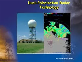
DUAL-POLARIZATION OF WSR-88D NETWORK. Edward Fenelon, National Weather Service, Chicago, IL. Emergency Management Meeting. Doppler Radars. Dual-Polarization Radar: Coming Soon!. Impacts entire WSR-88D network Several new products available Training content still evolving.

E N D
DUAL-POLARIZATION OF WSR-88D NETWORK Edward Fenelon, National Weather Service, Chicago, IL Emergency Management Meeting
Doppler Radars Dual-Polarization Radar: Coming Soon! • Impacts entire WSR-88D network • Several new products available • Training content still evolving
Dual-Polarization Radar Technology:Current Schedule for Upgrade • KLOT will be part of the Beta Test period • February 28 – March 13, 2011
What is Dual-Polarization? • A radio wave is a series of oscillating electromagnetic fields. If we could see them, they would look like this: Polarization currently used by WSR-88D’s
What is Dual-Polarization & How Is ItDifferent from Conventional Doppler Radar?? • Most radars (WSR-88D included) transmit and receive radio waves with a single, horizontal polarization • Polarimetric radars transmit and receive both horizontal and vertical polarizations • This is most commonly done by alternating between horizontal and vertical polarizations with each successive pulse
Polarimetric Radar: • Polarimetric radars measure both the horizontal and vertical dimensions of cloud and precipitation particles – can determine SIZE and SHAPE
Why are two poles better than one? • By comparing these reflected power returns of the two phases in different ways (ratios, correlations, etc.), we are able to obtain information on the size, shape, and ice density of cloud and precipitation particles, as well as better identify non-weather echoes.
Benefits of Dual-Polarization: • Detect when hail is present in a thunderstorm • Detect areas of heavy rain better (Improved precipitation estimation via determining droplet distributions (rainfall rates)) • Differentiate rain, snow, melting snow • Identify non-weather echoes more easily • Detect debris lofted by significant tornadoes
Using Shape and Variety Info to Differentiate Rain, Snow, and Melting Snow
Using Shape and Variety Info to Differentiate Rain, Snow, and Melting Snow
Using Shape and Variety Info to Differentiate Rain, Snow, and Melting Snow • Correlation Coefficient (CC) • 0.96<CC<1 – Small hydrometeor diversity* • 0.85 <CC<0.96 – Large hydrometeor diversity* • CC < 0.85 – Non-hydrometeors present • * refers to sizes, shapes, orientations, etc.
Using Shape and Variety Info to Differentiate Rain, Snow, and Melting Snow Reflectivity: Correlation Coefficient: High CC indicates all one precip type Low CC indicates mix (melting)
Using Shape and Variety Info to Better Detect Hail Z on right: note high reflectivity core in purple ZDR on left: note minima of near zero where highest Z co-located. This indicates hail core!
ZDR > 0: • Positive ZDR indicates a mean power return profile wider than it is tall • Larger positive ZDR usually indicates the presence of larger liquid drops • Falling rain drops flatten into “hamburger bun” shape (generally range from 0.5 to 5.0 dB)
ZDR ~ 0: • ZDR values around zero indicate a spherical mean profile power return • Tumbling hail stones result in nearly spherical return
Rain/Sleet Changing to Snow: Left: High ZDR indicates liquid covered sleet/snow Right: 2 hours later, precip changing to snow. Note decrease in ZDR
Dual Pol Radars Can Detect Debris From Significant Tornadoes Hook echo region of supercell can sometimes be characterized by area of enhanced reflectivity with low ZDR values and low CC values. • Beneficial when tornado obscured: • At Night • Rain Wrapped
Potential Derived Products: Hydrometeor Classification Algorithm • Assigns hydrometeor classification to each range bin (11 types). Uses base output, MLDA output and “fuzzy logic”
Estimation of Rainfall Amounts Areas either side of hail shaft – similar values of Z, but area NW has much lower values of ZDR – much higher concentration of smaller drops
Want to Learn More Details about Dual Polarization Radar? • Dual-Polarization Radar Training for NWS Partners • Meteorologists • Non-Meteorologists who use the data • Technology Overview • Hydrometeor Classification Product • Estimated Rainfall Amount Products • www.wdtb.noaa.gov
Summary • Dual-Polarization will arrive KLOT March 1, 2011 • New base products and new derived products, but nothing gone from what you’re currently using • Improved precipitation estimates, identification of freezing/frozen/liquid precipitation types, location of hail cores, updrafts, etc. • Identification of non-meteorological returns, and better filtering from processed data
Thank You! Edward.Fenelon@noaa.gov www.weather.gov/chicago www.weather.gov/rockford