Download
1 / 32
330 likes | 409 Views
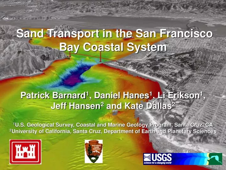
Sand Transport in the San Francisco Bay Coastal System Patrick Barnard 1 , Daniel Hanes 1 , Li Erikson 1 ,

E N D
Sand Transport in the San Francisco Bay Coastal SystemPatrick Barnard1, Daniel Hanes1, Li Erikson1, Jeff Hansen2 and Kate Dallas21U.S. Geological Survey, Coastal and Marine Geology Program, Santa Cruz, CA2University of California, Santa Cruz, Department of Earth and Planetary Sciences
Recent USGS Research • San Francisco Bay Coastal System historical changes • Recent morphological changes • Ocean Beach, incl. nearshore disposal site • West-central Bay • Crissy Field • Golden Gate and Angel Island sand wave fields • Detailed process studies • Ocean Beach • SF Bar • Golden Gate • Crissy Field • Bedform analysis adjacent to Golden Gate • Angel Island sand waves • Sediment sampling and multibeam mapping
SF Bar Bathymetric Change 1873 to 1900 1900 to 1956 1956 to 2005 K. Dallas
SF Bar Bathymetric Change • Crest contracted radially 1 km • Bar eroded vertically 80 cm • From 1900-1956 changes consistent with a reduction in tidal prism and increased sediment supply • From 1956-2005 changes reflect reduced sediment supply and/or tidal prism • Survey of the SF Bar was recently completed in 2009 for the California State Waters Mapping Project K. Dallas
Recent Changes Suisun Bay (1942-1990) -53 million m3 (-1.1 mcm/yr) San Pablo Bay (1951-1983) -22 million m3 (-0.7 mcm/yr) Central Bay (1947-1979) -51 million m3 (-1.6 mcm/yr) SF Bar (1956-2005) -92 million m3 (-1.9 mcm/yr) South Bay (1983-2005) +11 million m3 (+0.5 mcm/yr) Estimated sediment loss in last 50 years =240 million m3
Major Anthropogenic Activities San Francisco Bay System sediment loss = 240 million m3 (est. last 50 years) Bay development (last century) = reduction in tidal prism of ~ 30% Delta modifications = ~ 50% reduction in suspended sediment flux 1957-2001 (Wright and Schoellhamer, 2004) Ship channel dredge disposal offshore (1931 - 1971) = - 21 million m3 Dredging, borrow pit mining, and aggregate mining (1900 - present) = - 200 million m3 Ship channel dredge disposal nearshore (1971 - present) = + 18 million m3
Assessing the Impact • Tally up sediment removed from system • Identify sediment transport pathways, patterns and sources • Historical shoreline and bathymetric change analysis • Bedform morphology • Numerical modeling • Physical process studies • Sediment core analysis • Sediment provenance
Sediment Removal • 200 million m3 of sediment removed from system • 113 million3 from Central Bay • 75 million3 identified as sand (50 million3 from Central Bay) • Records incomplete • Missing many borrow pit mining records • No aggregate mining records pre-1974 (began in 1930’s) K. Dallas
1997-2008 Bathymetric Change • ~3-fold increase in rate of erosion • (-3.2 cm/yr) from 1947-1979 change analysis (Fregoso et al., 2008) • Lease sites lost sediment at a rate 5 times higher than rest of study area • 10.8 million m3 of sediment was removed by aggregate mining from 1997-2008 • No borrow pit mining or dredging was performed in this area from 1997-2008 • 85% of sediment removed was not naturally replenished
- 443 transects - 3,386 bedforms
Delft3D Modeling FLOW grid
SF Bay Coastal System Model • 4 domain 3D model • 10 layers • Grid cell size in region • of GG ~50 (ac) x 70 (cc) nbay.grd Sacramento river inputs Neumann boundary San Joaquin river inputs cbay.grd water level boundaries defined by tidal constituents sbay.grd sea.grd Neumann boundary L. Erikson
Predicted sediment transport - ‘hydrodynamic tide’ L. Erikson
Net Sediment Flux L. Erikson
Golden Gate Sediment Flux In January 2008, we collected sediment samples, ADCP data, and CTD-LISST profiles along two transects across the Gate L. Erikson
Golden Gate Model-Data Results L. Erikson
Ocean Beach Changes J. Hansen
South Ocean Beach Erosion J. Hansen
Change in Nearshore Wave Heights K. Dallas
Change in Nearshore Wave Heights K. Dallas
Regional Shoreline Changes • In SF Region, rate of accretion increased 4-fold from long (~ last 100 years) to short term (~ last 20 years) • Shift to erosion where SF Bar attaches at Ocean Beach • San Mateo region strongly erosional in long-term (93%) and short-term (98%) • In SM region rate of erosion increased by 50% from long to short term K. Dallas
Provenance Study Approach Objective: Apply multiple approaches to identify the source and pathways of beach-sized material in the San Francisco Bay Coastal System Funding: USGS and California Sediment Management Workgroup (CSMW) • Remote techniques • Bedform asymmetry • Numerical modeling • Direct sampling and physical characteristics • Morphometric analyses (grain size, shape, sorting, etc) • Foraminiferal analysis (McGann) • Geochemical analysis • Isotopes, 143Nd/144Nd and 87Sr/86Sr (Hein) • X-ray diffraction (Hein) • Heavy minerals (Woodrow and Wong) • Rare earth elements (Rosenbauer)
What we know • Historical changes • Short-term changes/patterns/processes • Semi-quantitative information on transport pathways • What we are working on (What we know we don’t know) • Golden Gate sediment flux • Sand provenance • Questions/Comments? (What we don’t know that we don’t know?) • http://walrus.wr.usgs.gov/coastal_processes/ Summary