Download
1 / 27
300 likes | 873 Views
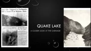
Quake Lake. The Story of the 1959 Hebgen Lake Earthquake. Hebgen Lake, Montana. In 1959, a 7.5 magnitude earthquake struck the area known as Hebgen Lake, Montana, just west of Yellowstone National Park. Hebgen Lake, Montana. Epicenter.

E N D
Quake Lake The Story of the 1959 Hebgen Lake Earthquake
Hebgen Lake, Montana In 1959, a 7.5 magnitude earthquake struck the area known as Hebgen Lake, Montana, just west of Yellowstone National Park.
Hebgen Lake, Montana Epicenter
Fault Scarp - A fault scarp is a feature on the Earth’s surface that looks like a step or scar. It is created by slip along a fault during an earthquake. Several new fault scarps formed during the Hebgen Lake earthquake. The largest was the Red Canyon scarp located north of Hebgen Lake. It is 14 miles long with a maximum height of 21 feet.
Dead End Evacuating after the Hebgen Quake was not easy! A splay of the Red Canyon fault scarp lifted a 10-foot wall across the road, blocking escape in that direction. Road Bed
Hebgen Fault Scarp The north shore of Hebgen Lake was submerged when the rock on which it rests dropped down adjacent to the new Hebgen fault scarp. The main residence at Hilgard Lodge dropped off its foundation into the lake and floated to this location.
Tilted Lake The sudden down-dropping movement along the new Hebgen fault scarp tilted the lakebed, causing the water in the lake to shift towards the north shore (left). The shift created a sloshing motion in the lake called a seiche wave. Notice the newly-formed Hebgen fault scarp to the far left and the small landslide (upper third of photo) that dropped part of Highway 287 into Hebgen Lake.
Seiche Waves Driftwood was thrown up onto the road by the seiche waves (oscillatory waves) in Hebgen Lake.
High and Dry Northward tilting of Hebgen Lake submerged the north shore and left these boat docks high and dry along the south shore. This down-dropping of the lakebed caused the waves that overtopped the dam 4 times and continued oscillating 11 1/2 hours.
These seiche waves were caused by the sudden down-dropping and tilting of the lake bottom during the earthquake According to eye-witnesses, seiche waves overtopped the dam 4 times and continued oscillating in the lake for 11 1/2 hours after the actual quake. The Hebgen Lake Dam is a man-made, earth-fill, concrete core dam that was built on the Madison River in 1914. The dam survived the intense vibrations of the earthquake as well as the repeated seiche waves which overflowed from Hebgen Lake.
Seiche Wave George Hungerford, dam caretaker, observed 3-4 foot surges of water overtopping the dam. Each surge of water flowed an estimated 10 minutes before withdrawing. The earthquake also caused the earth-fill to crumble away, leaving the concrete core wall exposed. Its sod covering remained in place. The earthquake and seiche wave also created several cracks in the dam. The largest of the 16 cracks in the wall was 3 1/2 inches wide. Despite all of this the dam held.
U.S. Forest Service smoke jumpers were first into the area between Hebgen Dam and the landslide to check on campers, administer first aid, and relay rescue needs to the outside world.
Landslide The earthquake also triggered a large landslide downstream from Hebgen Lake along the Madison River Canyon. The Madison Canyon landslide, six miles below Hebgen Dam, was the most devastating result of this earthquake. Nearly half of a mountain fell to the canyon bottom, Credit: MHS Photograph Archives, Helena
The Madison Canyon landslide, six miles below Hebgen Dam, was the most devastating result of this earthquake. Nearly half of a mountain fell to the canyon bottom, covered part of Rock Creek campground, blocked State Highway 287, and dammed the Madison River, causing Earthquake Lake to form. Twenty six people were killed by this landslide, but only seven bodies were found. The remaining 19 are presumed buried under the landslide. This photo was taken the day after the earthquake.
Before and After These photos by the USGS show the Madison River Canyon near Rock Creek campground before the slide (left), and after (right). When the south mountainside collapsed, it formed a natural dam that blocked the flow of the Madison River, forming Earthquake Lake.
Trapped The dropping of the lake-bed and four small landslides destroyed portions of Highway 287 above the man-made dam. Thus, for people in the Madison Canyon below the man-made dam but above the landslide when the quake hit, all exit routes were blocked.
Rescue and Recovery Efforts Because of the blocked roads, rescue crews had to hike into the canyon. Divers were brought in to look for bodies in the newly formed “quake lake” while other search and rescue volunteers combed the canyon, looking for potential survivors.
Restoring the River Once Hwy 287 was cleared and rebuilt, bulldozers were brought in to create a spillway though the landslide was blocking the flow of the Madison River through Madison Canyon. However, most of the landslide was left in place, and “Quake Lake” can still be visited today.
Damage in Yellowstone National Park The earthquake caused rockfalls and landslides throughout the northwest section of Yellowstone National Park. This rockfall blocked the road at Golden Gate Canyon. A later slide just missed five park workers. New geysers erupted, and massive slumping caused large cracks in the ground from which steam emitted. Many hot springs became muddy.
Other Damage Two people died at Cliff Lake Campground, 15 miles southwest of the Madison Canyon landslide, when a large boulder bounced over the picnic table and landed on their tent. Their three sons, sleeping a few feet away, were not injured. Picnic Table
Hebgen Lake, Montana, Earthquake August 1959. Fault scarp at Cabin Creek. 1959.
Hebgen Lake, Montana, Earthquake August 1959. Scarp area at the head of the Kirkwood earthflow, showing maximum distension of the surface, toppled trees, soil destroyed, and much subsoil. View is east from the east edge of the flow.
The Red Canyon fault scarp cuts through the old Culligan barn at the Blarneystone Ranch. The “barn” was actually part of the servants' quarters of Blarneystone Ranch. The barn sits mainly on the down thrown block. The fault scarp here is 10 to 12 feet high. A small collapsed shed (green roof) was on the upthrown block. It was completely destroyed. The fault scarp ends in the small grove of aspen which shows just beyond the “barn”.
Hebgen Lake, Montana, Earthquake August 1959. Landslide into Hebgen Lake. August 1959.
Red Canyon fault scarp as exposed along the south flank of Kirkwood Ridge near the head of Kirkwood Creek. The fault scarp here is wholly in colluvial debris. Part of the slickensides have been chopped away to show the general texture of the material. The slickensides dip downslope, reflecting direction of the movement of the colluvium. August 1959.