Download
1 / 28
290 likes | 644 Views
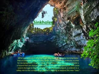
Sinkholes. Modeling, and Soil Survey. Objectives. Examine a few techniques and efforts to model karst features for map unit and/or component delineation. Consider some case studies of mapping and updating karst areas: Lawrence co, Indiana Springfield plateau, Missouri.

E N D
Sinkholes Modeling, and Soil Survey
Objectives • Examine a few techniques and efforts to model karst features for map unit and/or component delineation. • Consider some case studies of mapping and updating karst areas: • Lawrence co, Indiana • Springfield plateau, Missouri
GIS techniques to enhance identification of karst Karst: Dade county, MO
Sinkholes: 3x vertical exaggeration, 5m display resolution (10m DEM)
Flowaccumulation (multi-path): karst area Didn’t work that well…
Karst: wetness index (multi-path) Works fairly well for some sinkholes. However, not all upland wet areas are sinkholes.
Can we model these sinkholes? • Moderately high elevation Avg about 325m; range about 315 to 335m • High Flow accumulation Above about 200 • High Wetness Index Above about 9 • Not on the stream network Not so easy to model
Fuzzy Membership Model for Sinks Higher-elevation valleys confounded w sinks What about using streams in the model? USGS streams layer is incomplete (missing tributaries) Modeled stream network runs into sinks
Fuzzy Membership Model w more restrictive lower elevation criteria (lost the lowest elevation sinkhole)
Simple Fuzzy Membership model for Pierpont sinkhole areas: High elevation (full membership above 225m) High wetness index (full membership above 5) Does an OK job of identifying areas where the sinkholes occur
Mapping karst in SSURGO • How can we identify karst features in… • Spatial data • Attribute data • How might this affect interpretations? • Case studies: karst in soil survey • Lawrence county, IN • Springfield Plateau (MLRA 116B), MO
Karst mapping: Lawrence county, IN Acknowledgements: Dena Marshall (now Lexington KY) GennyHelt (Indianapolis IN)
Physiographic Features of southern Indiana (Schneider, 1966)
A closer look at features of the Crawford Upland & Mitchell Plain
KY & IN Sandstone & Shale Hills & Valleys Lawrence county - 30m DEM - MLRAs How do the lines look? Where’s the karst? Highland Rim & Pennyroyal KY & IN Sandstone & Shale Hills & Valleys
Physiographic Regions Mitchell Plain: middle Mississippian- aged limestones Norman Upland Mitchell Plain Crawford Upland
Karst map units in Lawrence county, IN Note: no sinkhole spot symbols
The karst soils in Lawrence county • “Terra rossa” • Loess over “residuum” (in situ?) • Crider • Fi-siTypicPaleudalfs • 10R w depth • Knobcreek (Frederick correlated to this in IN) • Fi-si / clayey TypicPaleudalfs • Not as red
Mapping patterns & rules • Limestone underlain w siltstone: little/no karst. • Limestone thickens westerly; sinkholes appear. • IN Geomorphology Tour “some years ago”: • Karst map unit: • Areas w sinkhole density of > 1 per 5 acres • Spot symbol: • Sinkhole density < 1 per 5 acres Ref: Pers. Comm., Dena Marshall, SS, currently Lexington KY
Attributes (NASIS soil properties) • Bedrock in a karst component within 80” • Higher Ksat than corresponding non-karst unit • Entry for Ksat in R layer • E.g., Navilleton components, Floyd co IN: • Karst component: R Ksat 1.42 – 141.14 • Non-karst component: R ksat 0.43 – 42.34 • Bedrock below 80” • No known differences in soil properties between karst and non-karst map units • If we could populate soil property data below 80”, there would be differences.
MLRA Soil Survey Project:Updating Karst Areas on the Springfield Plateau (MLRA 116B) County-based soil surveys (over 40+ years) handled karst in various ways. • Ignored in some, • Spot symbols in some, • Karst map units in some. • Inconsistent use of all of the above, both within and among counties. Springfield Plateau
Karst Project: Methodology • Primarily a GIS office project • Utilize: • Elevation data • DEMs, Hypsography lines • Existing SSURGO • Orthophotos • Sinkholes layer (statewide; USGS) • On-screen digitizing/editing of SSURGO • Establish new map units • “Karst” in name, or • Soil series that occur only in sinkhole basins.
Results: 20 new map units in 7 counties • “Karst” map units; e.g., • Goss grsil, karst, 8-15% • Sinkhole basin map units; e.g., • Lowassiesil, 0-3%, freq. ponded Zoom in to this area (next slide)
Map units added in this area Blue = sinkhole basin units; Red = “Karst” in MU Name
Karst discussion “answers” • Spatial identification of karst: • Map unit phases (i.e., “karst” in muname). • Spot symbols. • Map units named by components that only occur in karst (i.e., no need for “karst” in muname). • e.g., in Missouri: Lowassie, Grandgulf series only occur in sinkholes. • Attribute interpretation • Muname contains “karst” • Component geomorphic description table: landform = “sinkhole” • Differences in soil properties? • Interpretations • Possibility for groundwater contamination • Onsite wastewater disposal; lagoons; others? • Not keyed in standard National Interps (?) • Custom, state-created interps (e.g., MO onsite wastewater interp) • Keys on “karst” in the muname, and “sinkhole” landform