Download
1 / 17
240 likes | 854 Views
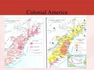
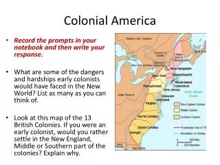
12. 13. Page 13. The Geography of Colonial America. Lesson 3. Lesson 3: The Geography of Colonial America. L 12. Knowledge Check. Without using any helps… List the 13 colonies. Picture in your head where they go. List some KEY physical features of eastern North America.

E N D
12 13
Page 13 The Geography ofColonial America Lesson 3
Lesson 3: The Geography of Colonial America L 12 Knowledge Check Without using any helps… List the 13 colonies. Picture in your head where they go List some KEY physical features of eastern North America.
Lesson 3: The Geography of Colonial America R 13 LEARNING TARGETS: • I can locate the 13 British colonies in America. • I can locate the five key British cities in America. • I can locate the (12) major physical features of colonial America. • I can explain the impact of the geography of colonial America.
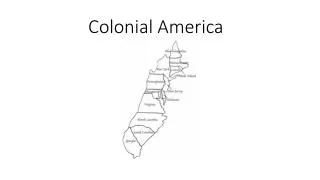
Lesson 3: The Geography of Colonial America R 13 L 12 Setting the Stage • Open the textbook to pages 84 and 85. Place the MAP. Place the HANDOUT. • Complete questions 1 through 6 (front side) with complete sentences AND fill out the map as directed. Read page 85 and use the maps on 84 and 85 to find the answers. • Complete questions 7 through 9 (back side) with complete sentences.
Lesson 3: The Geography of Colonial America • Label each colony on the map. • Also add and label; the colonies’ largest cities: Boston, New York, Philadelphia, and Charleston. • What do the locations of all four cities have in common? Each of the four cities is a port and is located on or close to the Atlantic Ocean.
Lesson 3: The Geography of Colonial America • Draw and label the Appalachian Mountains on your map. • How many colonists per square mile lived across most of this region? The population density in most of this region was between 2 and 15 people per square mile.
Lesson 3: The Geography of Colonial America • Circle the region where most colonists lived. • What cities does this region include? The most heavily populated colonial region included Boston, Philadelphia, and New York City.
Lesson 3: The Geography of Colonial America • Shade in the colonies that had large populations of Loyalists. • Which of the three main colonial regions had the fewest Loyalists? The New England colonies had the fewest Loyalists.
Lesson 3: The Geography of Colonial America • Based on your map, in which colonies do you predict the goal of independence would have been strongest? • Use information from your map to explain why. The goal of independence would have been strongest in New England because that is where the fewest Loyalists lived.
Lesson 3: The Geography of Colonial America • Label Lake Champlain and the Hudson River. • Also add and label Albany. • If British armies in Canada and New York City wanted to divide New England from the rest of the colonies, how could they have used the physical geography of this region to carry out this strategy? The first British army could have come south from Canada along the Hudson River, while the second British army in New York City could have come north up the Hudson River, meeting up somewhere in between.
Lesson 3: The Geography of Colonial America The Geography of Colonial America • In addition to the Appalachian Mountains, Lake Champlain, and the Hudson River, you also are responsible for knowing the following features: • Atlantic Ocean • Chesapeake Bay • Delaware Bay • Delaware River • Lake Erie • Lake Huron • Lake Ontario • Ohio River • Ohio Valley
Lesson 3: The Geography of Colonial America • Look at the population density map in your book. How does the amount of settlement along the coast of the 13 colonies compare to the amount of settlement farther inland? • What is one possible reason for this? Areas near the coast were generally more densely settled than areas farther inland. One possible reason is that coastal areas were settled first and the colonies gradually spread inland.
Lesson 3: The Geography of Colonial America During the first phase of the American Revolution, most major battles took place near the cities of Boston, New York, and Philadelphia. Why would controlling this region have been an important goal for both sides in the war? This was the most heavily populated area of the colonies, containing three of the colonies’ four largest cities. Controlling this region would have given either side control of a large part of the colonies’ total population.
Lesson 3: The Geography of Colonial America After years of fighting in the New England and Middle Colonies, British forces invaded Georgia and South Carolina. Based on your map and the maps in your book, why might the British have believed they could conquer this region? Loyalists were strong in these colonies. The British might have expected that these Loyalists would help them in the war. Also, these colonies were not heavily settled, so there would be fewer people to conquer.
Lesson 3: The Geography of Colonial America 11 6 NEW ENGLAND COLONIES New Hampshire – 1623 Massachusetts – 1620 Rhode Island – 1636 Connecticut – 1636 13 12 9 MIDDLE COLONIES 10 New York – 1625 7 8 New Jersey – 1630 5 Pennsylvania – 1682 Delaware – 1638 4 SOUTHERN COLONIES Maryland – 1634 3 Virginia – 1607 North Carolina – 1663* 2 South Carolina – 1663* Georgia – 1732 1 * Carolinas split in 1729
Lesson 3: The Geography of Colonial America 5 - Appalachian Mountains 11 - Atlantic Ocean vv 10 vv 3 - Delaware River vv vv 9 vv 2 - Hudson River 8 vv vv 2 vv 7 - Lake Erie vv vv 7 vv 9 - Lake Huron 3 vvv vv v 8 - Lake Ontario vv vv 4 vv 12 10 - Lake Champlain vvv 1 vv 6 vvvv 1 - Ohio River 5 vvv 12 11 vvv vvvv 12 - Ohio Valley vvvv vvvv vvvv 4 - Delaware Bay vvv vvv vvv 6 - Chesapeake Bay