Download
1 / 10
100 likes | 153 Views
Facetted browsing of Rockcarvings. Fredrik Palm, HUMlab 2012. How does ”Hacka” looks like? Where are they located?. How does it work?. Filtering downwards. Different result views with customized output. What type of rock-carvings are located on Northen slopes on ”Brådön”-island ?.

E N D
Facetted browsing of Rockcarvings Fredrik Palm, HUMlab 2012
How does it work? Filtering downwards Different result views with customized output
What type of rock-carvings are located on Northen slopes on ”Brådön”-island?
Saving ”interface” • http://rockart.humlab.umu.se//?view_state=5470&application_name=hsm
Saving data GIS , Geography Markup language Excel list
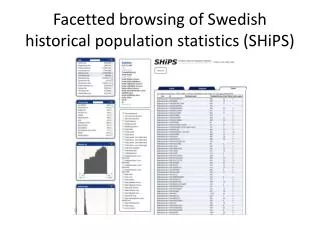
Benefits HUMlab’s Facetted browsing Search Limits search term known by users Quick response • Can reveal unknown content to user • Can support different perspectives to the dataset • Can describe correlation in dataset • Can anticipate new research question • Works over any relational database • Easy to integrated with new databases
Technical infrastructure • Server with postgres and POSTGIS for any relational data and GIS-data • PHP for serverside operation, building SQL and creating content • Jquery and javascript for web-client • Highcharts and Google map API • Minnesota map server for dynamic maps • Batik Rasterizer for SVG-download of diagrams • Multicore processors to take advantage of threading of application.
Current usage • QVIZ, Query and context based visualization of time spatial cultural dynamics,EU-FP6-IST Patrik Svensson/Fredrik Palm) • SEAD, Strategic environmental database, Swedish Research council. (MAL, Phil Buckland) • SHIPS, Swedish historical demographic statistics, Swedish Research council (DDB, Sören Edvinsson) • DIABAS, Dialect Database of Scandinavian Dialects, The Gustavus Adolphus Academy. (Department of Language Studies Lars-Erik Edlund) • CitizMap, Integrated e-mapping and visualization services for citizens, researchers and policy makers, VINNOVA, Sweden’s Innovation Agency. (Tallinn City, Estonia, Maria Lille) • Rockart, Digital publication of Rock carvings of Nämforsen. County of Västernorrland, Culture heritage. (Patrik Svensson/Fredrik Palm) • MJCB, Mapping the Jewish Communities of the Byzantine Empire, FP7-ERC (via Cambridge University, Nicholas De Lange)