Download
1 / 76
780 likes | 1.15k Views
Oceans. Physical and Chemical Oceanography. The World Ocean . Topics to cover…………. Composition of ocean water Temperature of ocean water Effect of the ocean on climate The ocean floor Movements of ocean water Effects of the ocean on the shoreline Future of the ocean.

E N D
Oceans Physical and Chemical Oceanography
The World Ocean • Topics to cover…………. • Composition of ocean water • Temperature of ocean water • Effect of the ocean on climate • The ocean floor • Movements of ocean water • Effects of the ocean on the shoreline • Future of the ocean
Physical Oceanography How and why ocean currents flow, air-sea interactions such as the generation of waves by the wind.
Chemical Oceanography Composition of sea water and the processes controlling and altering its composition, including marine pollution.
The Hemispheres of the Earth Northern Hemisphere is approximately 39% land. The Southern Hemisphere is approximately 19% land.
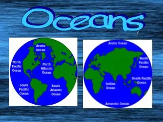
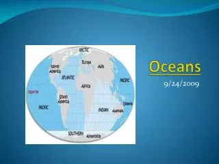
The World Ocean • Covers about 71% of Earth’s surface • Subdivided into 5 smaller bodies also called oceans: (in order of size) • Pacific Ocean – world’s largest ocean • Atlantic Ocean • Indian Ocean • Antarctic Ocean • Artic Ocean
The World Ocean • Ocean floor lies farther below sea level than the continents rise above sea level • average depth of ocean floor is about 4 kilometers below sea level; average height of the continents is about 0.8 km above sea level • Deepest part of the world ocean is the Mariana Trench (in Pacific Ocean) - the bottom of the Mariana Trench is almost 11 km below sea level; top of the highest mountain on land (Mr. Everest) is about 8.8 km above sea level
Composition of Ocean Water • Dissolved solids • 75% of salt is sodium chloride; remainder consists of other salts (MgCl and Mg SO4) • Weight of salts in a given volume of water is a measure of salinity • Average salinity about 35% (One kg of seawater contains about 35 grams of salts) • Gold, silver, uranium, and iodine are a few other solids also found in seawater (in small amounts)
Composition of Ocean Water • Dissolved gases • Gases include nitrogen, oxygen, and carbon dioxide • Dissolved oxygen and dissolved carbon dioxide in seawater are important for survival of ocean organisms (fish, lobsters, clams, seaweed, algae)
Temperature of Ocean water • Temperature varies with depth and latitude • Fairly uniform to a depth of 90 meters • This results from surface winds churning the warm, upper layers of water • From a depth of about 90 m to 900 m, at the equator, temperature falls rapidly • In general, surface temperature of ocean water becomes gradually colder traveling from the equator to either pole
Ocean Temperature at the Equator Pure water freezes at 0 degrees, because of dissolved salts, seawater freezes at about -2
Temperature of Ocean Water • Temperature of surface water at the equator may be as high as 330C • Surface water at the poles may be as low as ----20C (close to freezing) • Temperature of surface water changes throughout the year
Our Layered Oceans Surface mixing zone is warmest; saltiest near bottom of zone. Transitional zone contains thermocline and halocline. Deep zone is 2 tons per square inch and coldest in temperature.
Effect of the Ocean on Climate • Large bodies of water greatly influence the average temperature of nearby coastal regions • Water …. • absorbs heat slowly • holds heat well, and • gives off heat slowly In winter, water acts like a radiator; in summer like an air conditioner
Salinity Remember, in general, the following are true: • Surface salinities increase near the 20-degree latitudes in the Atlantic and Pacific Oceans. • Salinities decrease with depth at the halocline near the equator and the Tropics, but increase at high latitudes where there is no halocline.
Halocline • In oceanography, a halocline is a subtype of chemocline caused by a strong, vertical salinity gradient within a body of water. • Because salinity (with temperature) affects the density of seawater, it can play a role in its vertical stratification. • This Increase in salinity by one kg/m3 results in an increase of seawater density of around 0.7 kg/m3
Salinity • Remember, in general, the following are true: • (continued) • Temperature and density are mostly inversely proportional to each other. • Temperatures in the oceans drop at the thermocline except for at high latitudes where they remain constant.
Thermocline • A thermocline is a thin but distinct layer in a large body of fluid in which temperature changes more rapidly with depth than it does in the layers above or below. • In the ocean, the thermocline may be thought of as an invisible blanket which separates the upper mixed layer from the calm deep water below.
The Ocean Floor • Exploring the ocean floor • Sailors sounded (determined ocean depth) by dropping a measured line with weight tied to it over the side of a ship • Today, oceanographers use echo sounding • Sends out sound waves through the water • Bathyscaphs – submarines specially built to explore the ocean floor
Ocean Floor • Probably have accurately mapped only 5% of the ocean floor. • Currently also using dense satellite altimeter measurements to construct a uniform resolution map of the seafloor topography. • These maps do not have sufficient accuracy and resolution to be used to assess navigational hazards but they are useful for such diverse applications as locating the obstructions/constrictions to the major ocean currents and locating shallow seamounts where fish and lobster are abundant.
Ocean Topography *Oceanographers studying the oceans and ocean floor have delineated three (3) major units: 1. Continental margin 2. Ocean basin floor 3. Mid-oceanic ridges
Continental Margin The continental margin includes: Continental shelf -- very gentle slope (submerged land) Continental slope -- steep slope on edge of continental shelf. Continental rise -- gentle slope where trenches do not exist Deep sea fansexist where sediment is accumulated and falls off of the continental slope. Mixture of sediment-laden heavy water forms submarine turbidity currents.
Ocean Topography Seamount
What else is at the bottom of the ocean? Answer: Hydrothermal vents …a.k.a… Black smokers!
Oceanic zones • The oceanic zone is subdivided into several zones: • Euphotic (photic) zone • Disphotic • Aphotic zone
Euphotic Zone • Also called photic or sunlit zone • receives enough sunlight to support photosynthesis • temperatures range anywhere from 40 to −3 °C
Coral Reefs and Atolls • Reefs - develop usually in relatively shallow water • where light is present • organisms can thrive on nutrients and food sources in a warm water setting • Atolls develop in response to a sinking of the oceanic crust.
Disphotic Zone • Where only small amounts of light penetrate • lies below the euphotic zone • referred to as Twilight Zone (scarce amount of light) • temperatures range from 4 to 5 °C • pressure higher, can be up to 1,470 psi (10,100,000 Pa) and increases with depth
Aphotic zone • 90% of the ocean in aphotic zone • no light penetrates. • also called the midnight zone • water pressure is very intense • temperatures near freezing range 0 to 6 °C
Deep Sea Ocean Zones • Pelagic zone - the ecological realm that includes the entire oceanwater column. Of all the inhabited Earth environments, the pelagic zone has the largest volume • Benthic zone - The benthic zone is the ecological region at the lowest level of an ocean or a lake
Deep Sea Deep ocean trenches(deepest part of ocean) some as deep as 36,000 feet Abyssal plainsare the flat portions of the deep ocean, likely to be the flattest portions of the earth. Isolated volcanic peaks (mantle hot spots) are referred to as "seamounts". Likewise volcanic cones near mid-oceanic ridges are called seamounts as well. Harry Hess called these “guyots”.
The Deep Sea • Mid-oceanic ridges • divergent plate boundaries occur (Mid-Atlantic) • narrow region at the ridge crest is called the rift zone.
Ocean Currents, Tides and Waves • Ocean circulation: • surface currents and deep-water masses • Some are short-lived: seasonal and local • Others are permanent and extend over globe • Generally, circulation patterns related to climatic conditions and heating of the Earth by the sun
Surface Currents • Important "river" of ocean is "Gulf Stream" • Flows -response to atmospheric conditions • Direct relationship with climatic conditions • Ocean currents move clockwise in northern hemisphere and counterclockwise in southern hemisphere • Directly related toCoriolis Effect, • a deflective force resulting from the Earth's rotation that often causes currents to move against the winds.
Shallow Ocean Currents El Niño and La Niña
Deep Ocean Currents • driven by gravityanddensity differences. • Two factors important for dense mass of moving water: Temperature Salinity • Cold, salty water is denser than warmer, less salty water. • deep ocean circulation is referred to as thermohaline circulation.
Thermohaline Circulation Cooler water at surface becomes saltier and denser - sinks to the bottom. As sinks it replaces lighter less dense water So, cold dense waters flow away from sources at the poles and are replaced by warmer waters from lower latitudes. It takes many years, possibly centuries for the dense, saline waters to migrate to the coastlines where upwelling may occur.
Deep Ocean Currents Deep ocean currents vertical (not horizontal like surface patterns) - Caused primarily by a response to density differences in ocean and contrasts in temperature and salinity.
Longshore Current Waves that crash against shorelines develop currents that take sand and sediment headlong parallel to the beach and is referred to as longshore current. Process is significant -measured to carry millions of tons of sand and sediment away from the beaches along the California Coast every year.