Download
1 / 9
90 likes | 217 Views
Sedimentary Deposition on the North and South shores of Long Island. By Brian Campbell, Levar Cassaberry, and Alex Reyes. The Big Question:. How are the sediments deposited on the North and South Shores of Long Island?. Hypothesis:.

E N D
Sedimentary Deposition on the North and South shores of Long Island By Brian Campbell, Levar Cassaberry, and Alex Reyes
The Big Question: • How are the sediments deposited on the North and South Shores of Long Island?
Hypothesis: • Larger sediments on the North Shore are deposited closer to the shore. • Smaller sediments are deposited further from the shore on the North Shore. • The South Shore will have smaller sediments than the North Shore. • The trend horizontal to the shoreline should be the same for both shores.
Materials Needed • 1 Garden shovel • 1 Box of durable freezer bags • 1 Heavyweight Canvas bag • 1 Permanent Marker • 1 Triple Beam Balance • Sieves with varying size screens • 1 marble composition book for record keeping
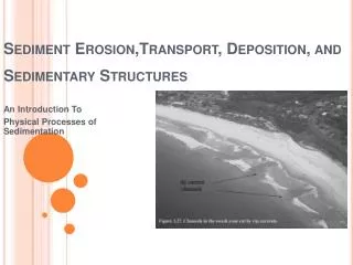
Sample Collecting Procedure • Choose a beach location for sample collecting • start out from the shoreline and dig up a measurable amount of sand. • Place the sand in a labeled freezer bag. • Repeat this process every 5 feet till you reach the dunes. • With the bags of sand place under light for it to dry.
The Measuring After collecting the sand samples, the sand was set to dry for approximately 24 hours. Samples were taken from each bag and weighed on a triple beam balance. Each sample was placed into a sieve containing four screens of decreasing sizes top to bottom. The amounts of sample that passed through each size screen were measured using the triple beam balance. The data was recorded and then plotted onto the following graphs for comparison.
Sunken Meadow Data As you can see, the two different grain sizes have completely opposite trends. The blue line indicates that the larger grain sizes are in decreasing amounts overall as you move from the shoreline toward the dunes while the smaller grains are increasing overall. Data indicates that where there is a greater percent of the larger grains and a smaller percent of the smaller grains a tide line is present. There fore the data shows two tide lines, high and low.
Robert Moses Data As you can see, the two different grain sizes have completely opposite trends. The blue line indicates that the larger grain sizes are in decreasing amounts overall as you move from the shoreline toward the dunes while the smaller grains are increasing overall. Data indicates that where there is a greater percent of the larger grains and a smaller percent of the smaller grains a tide line is present.
Conclusions…… • Larger sediments on the North Shore were deposited closer to the shore. • Smaller sediments were deposited further from the shore on the North Shore. • The South Shore had smaller sediments sizes than the North Shore. • The trend horizontal to the shoreline was the same as that of the North Shore.