Download
1 / 22
220 likes | 307 Views
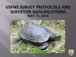
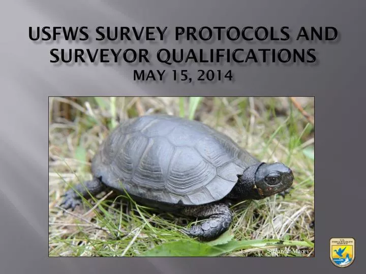
USFWS Survey Protocols and surveyor qualifications May 15, 2014. Suzanne Macey. What May Trigger the Need for Phase 1 Surveys?. DEC looks at known occurrences with 1 mile FWS looks at known occurrences plus the potential for suitable habitat Contact DEC and/or FWS for assistance.

E N D
USFWS Survey Protocols and surveyor qualificationsMay 15, 2014 Suzanne Macey
What May Trigger the Need for Phase 1 Surveys? • DEC looks at known occurrences with 1 mile • FWS looks at known occurrences plus the potential for suitable habitat • Contact DEC and/or FWS for assistance
What May Trigger the Need for Phase 1 Surveys? • Use the following analytical approach: 1. Is the proposed project within an area identified by the FWS as known or likely to contain bog turtles (IPaC)? • If no, no further coordination for BT necessary • If yes, then…
What May Trigger the Need for Phase 1 Surveys? 2. Is the proposed project at an elevation of 1,000 feet or less? • If no, no further coordination for BT necessary • If yes, then…
Phase 1 Surveys 3. Is there any suitable BT habitat present within the proposed project area? • Conduct Phase 1 survey – anytime, anyone • If results are no, submit results of Phase 1 survey report and field data sheets to NYFO for review • If results are yes, conduct analysis of effects and coordinate with NYFO to determine if Phase 2 or 3 surveys are necessary
Include in Phase 1 Report… • Data forms, including opinion on habitat • Topographic map of location of site • Details of project • Project design map • Show location of wetlands/streams • Wetland type (PEM, PSS, PFO, POW) • Designated survey areas • Color photos • Lead surveyor’s name • Date of visit • Description of hydrology, soils and vegetation, etc.
Analysis of Effects • Death or injury to bog turtles during construction activities • Filling/loss of nesting, basking, hibernation habitat • Fragmentation of habitat and alterations to dispersal • Introduction of contaminated surface water runoff • Temporary or permanent alteration of hydrology • Introduction of nutrients – septic, WWTP • Introduction of invasive species • Introduction of people, pets, and recreational vehicles into wetlands, etc.
Phase 2 Surveys? • Should the proposed project have the potential to impact BT, then there are 2 options: 1. Assume BT presence and avoid wetland impacts, or 2. Conduct Phase 2 survey (or possibly Phase 3 trapping)
Phase 2 Surveys • Note: Phase 2 surveys are only to detect presence or probable absence • Recommend “qualified surveyor” • Qualified surveyor must be permitted by DEC for location and period of survey • Survey should focus in areas of wetland that meet 3 criteria • Areas meeting criteria are “designated survey areas”
Phase 2 Surveys • Note: Phase 2 surveys are only to detect presence or probable absence • Recommend “qualified surveyor” • Qualified surveyor must be permitted by DEC for location and period of survey • Survey should focus in areas of wetland that meet 3 criteria • Areas meeting criteria are “designated survey areas”
Phase 2 Surveys • Conduct only between April 15 – June 15 • LPPPRU: May 1 – June 30 • Minimum of 4 surveys per wetland site • At least 2 surveys in May • April 15 – April 30: separate by 6 or more days • May 1 – June 15: separate by 3 or more days • Survey time should be at least 4 to 6 person-hours per acre • Once a BT is found, Phase 2 ends
Include in Phase 2 Report… • Details of project • Topographic map of location of site • Project design map • Proposed conservation measures • Map with coarse vegetation types • Table of current vs. proposed future acreage of veg • Wetland delineations and proposed mitigation • Color photos • Lead surveyor’s name • Results of survey • Details on suitable habitat that extends off-site, etc.
Results of Phase 2 Survey • The results of the Phase 2 can go two ways: 1. Results are negative for BT detection = - Coordination with NYFO ends for BT 2. Results are positive for BT detection = - Avoid all wetland impacts OR - Formal consultation or HCP necessary
Phase 3 Survey • Use when Phase 2 surveys fail to detect BT in: • Large wetland complexes • Areas of dense vegetation and/or • Low density • Must coordinate with NYFO – request protocol • Qualified surveyor must be permitted by DEC • Can trap concurrently with Phase 2 survey • Minimum 20 consecutive days – end by June 30 • Minimum 20 traps per hectare
Conservation Measures • See website for fact sheets: • LPPPRU • HHRU • Conservation Zones • Remove lot lines and associated construction activities from the 300 foot buffer around wetland (Zone 1) • Conduct pre-construction survey to remove any bog turtles from work area • Install silt fencing to prevent bog turtles from entering work area
Conservation Measures • Keep all disturbance, including equipment, vehicles, staging areas, temporary roads, and soil stock piles out of Zone 1 • Eliminate the use of basement window wells or require that window wells be covered or surrounded by a barrier to prevent trapping turtles • Use grate or catch basins with an opening size small enough to prevent trapping turtles • Ensure that uncontrolled runoff does not occur in the wetland and that water quality is protected
Conservation Measures • Stabilize disturbed areas after construction is complete • Avoid stormwater basins in Zone 1 • Construct retention basins on 3 to 1 slopes which would allow turtles of any species to escape • Place physical barriers between the useable area of each lot and the adjacent wetland buffer (e.g., natural fences, split rail, boulders)
Surveyor List • Phase 1 surveys – anyone can do • Phase 2 surveys – need to be qualified • Ability to find bog turtles • 100 turtles in the last 20 years • Independently found at least 20 turtles at 5 sites within the past 5 years • Minimum 2 full field seasons of MS or PhD-related work at a minimum of 2 sites and has independently found at least 5 turtles • Completed 4 years of certified apprenticeship program under current surveyor
Surveyor List • Extent of field experience with bog turtles • At least 2 field seasons working with turtles (e.g., surveys, telemetry) • Written documentation • Demonstrate ability to produce accurate, comprehensive, well-organized written reports
Surveyor List • Experience with implementing survey protocols • Phase 1: within the past 5 years, surveyor independently conducted at least 10 Phase 1 surveys, accurately determining whether or not potential turtles were present • Phase 2: within the past 5 years, surveyor conducted at least 5 Phase 2 surveys in the capacity of principal investigator or 10 Phase 2 surveys as an assistant • References • Need 3 references
Surveyor List Surveyors need to submit updated info annually by December 31 List will be updated in early Spring annually, periodic updates within the year as necessary Contact: Noelle Rayman New York Field Office noelle_rayman@fws.gov 607-753-9334