Download
1 / 23
230 likes | 461 Views
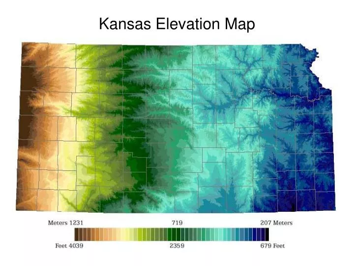
Kansas Elevation Map. Ozark Plateau. As its name suggests, this region is part of the Ozarks of Missouri, Arkansas and Oklahoma. Located in the southeastern corner of Kansas, this region is hilly with thin rocky soil that is poor for farming.

E N D
Ozark Plateau • As its name suggests, this region is part of the Ozarks of Missouri, Arkansas and Oklahoma. • Located in the southeastern corner of Kansas, this region is hilly with thin rocky soil that is poor for farming. • Oldest surface rocks in the state are found here. They formed during the Mississippian Period about 345 million years ago. • The region is the most heavily forested area in the state. • With a yearly average of 40 inches of precipitation, this is the wettest part of the state.
Ozark Plateau • Deposits of lead and zinc ores led to extensive mining in this part of the state. • Refuse of the rock crushed to obtain the lead and zinc ores (known as chat) can be seen throughout the region in large piles. • Some mines have resulted in the contamination of ground water in the area. Galena (Lead Ore) Sphalerite (Zinc Ore)
Cherokee Lowlands • The Cherokee Lowlands consist of a gently rolling plain in southeastern Kansas. • The soils of the region developed from easily eroded shales and sandstones that were formed during the Pennsylvanian Period about 300 million years ago. These soils are very good for farming. • During this period, this part of Kansas was a swampy area with dense vegetation. The dead vegetation was covered by sediments and eventually formed coal. • Coal mining was an important industry in southeastern Kansas beginning in the late 1800s and continuing to today. • Coal was mined using both shaft and strip mining methods. Only strip mining is still used. Big Brutus
Osage Cuestas • This region occupies most of eastern Kansas south of the Kansas River. • Consists of a series of east-facing ridges or escarpments. The Spanish word for this type of formation is cuesta. • Between the ridges are flat rolling plains. These plains are good areas for farming. • The underlying rock strata or layers are Pennsylvanian limestones, shales and some sandstones that dip to the west or northwest. • The limestones and shales were deposited in shallow seas that existed between 290 and 310 million years ago.
Chautauqua Hills • Consists of sandstone-capped rolling upland that is about 10 miles wide. • Formed between 285 and 320 million years ago as rivers and streams flowed into the sea. Sand and other sediments were deposited in the mouth and delta of these rivers. • Over time, the deposits were buried and compacted to form the sandstones. • As the sandstones were exposed due to erosion, the more erosion-resistant sandstones capped the area’s hills. • The area is not suited to farming, but is used as pasture for cattle.
Flint Hills • The Flint Hills were formed by the erosion of Permian-age limestones and shales. During the early part of the Permian Period (which lasted from about 286 to 245 million years ago) shallow seas covered much of the state, as they did during Pennsylvanian times.
Flint Hills • Unlike the Pennsylvanian limestones to the east, many of the limestones in the Flint Hills contain numerous bands of chert, or flint. The chert erodes more slowly and caps most of the hilltops.
Flint Hills • Due to the cherty soils, the land is better suited for ranching than farming. • The Flint Hills is still largely native prairie grassland. • Except along streams, trees are rare.
Smoky Hills • The Smoky Hills occupy the north-central part of the state. It is characterized by outcrops of Cretaceous-age rocks and takes its name from the early morning haze that often gathers in the valleys.
Smoky Hills • During the Cretaceous Period (144 to 66 million years ago), Kansas was once again under water. Unlike the relatively shallow seas of the Pennsylvanian and Permian, the seas that advanced and retreated during the Cretaceous were deeper and more widespread.
Smoky Hills • Three principal rock outcrops characterize the Smoky Hills--the sandstones of the Dakota Formation, the limestones of the Greenhorn Limestone, and the thick chalks of the Niobrara Chalk.
High Plains • The High Plains region comprises almost all of the western one-third of the state. It is an area of vast flatlands and gently rolling hills, with topographic relief largely restricted to streams and river valleys. • The High Plains developed on sediments that originated in the Rocky Mountains to the west. The sediments were carried by streams and rivers into Kansas.
High Plains • Layers of sands and gravels that lie below the surface can contain large reserves of water. These are called aquifers. The largest of these is the Ogallala Aquifer.
High Plains • The High Plains receive less rainfall than other parts of the state. Only plants that are drought-resistant occur naturally in this area.
Red Hills • The rugged topography of the Red Hills are part of the Permian deposits (260 million years ago) found in south central Kansas. They get their color from iron oxide (rust), which turns bright red when exposed to oxygen. • It consists of shales, siltstones, and sandstones--along with interbedded layers of gypsum and dolomite, forming somewhat flat-topped red hills.
Red Hills • The Red Hills were known as the "Medicine Hills" to the Plains Indians. The waters springs and streams in the area contain calcium and magnesium sulfates and other natural salts. Many of these chemical compounds have therapeutic and healing effects. • Sinkholes are common features of the Red Hills region. These sinkholes were probably formed by the solution of salt and gypsum beds several hundred feet below the surface. The land above them collapsed into the empty space, leaving a dip or sinkhole at the surface.
Arkansas River Lowlands • The Arkansas River Lowlands is a relatively flat alluvial plain, made up of sand, silt and gravel. • The sediments were deposited by the Arkansas River during the last 10 million years as the river flowed through Kansas from its source high in the Rocky Mountains. • The river changes from a degrading stream (one that cuts downward in its channel) to an aggrading stream (one that builds up the riverbed) over its course.
Wellington-McPherson Lowlands • Like the Arkansas River Lowlands, the Wellington-McPherson Lowlands are flat alluvial plains. • The sand, silt, and gravel was eroded from slightly older rocks in the High Plains to the north, then carried by streams flowing south into the Arkansas River between one and two million years ago, during the Pleistocene Epoch. • The Wellington-McPherson Lowlands sit on top of one of the largest salt deposits in the world and is as much as 400 feet thick.
Glaciated Region • The Glaciated Region is the part of Kansas that was covered by at least two of the eight or nine glaciers that encroached upon much of the northern United States during the Pleistocene Epoch, between 1.6 million and 10 thousand years ago. • As glaciers advanced, they pulverized rocks and sediments in their path. This fine-grained silt is called loess. • Thick deposits of the yellowish loess, more than a hundred feet thick in places, occur along the bluffs of the Missouri River.