Download
1 / 15
150 likes | 310 Views
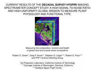
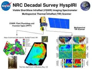
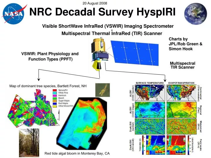
NRC Decadal Survey HyspIRI. Visible ShortWave InfraRed (VSWIR) Imaging Spectrometer + Multispectral Thermal InfraRed (TIR) Scanner. Charts by JPL/Rob Green & Simon Hook. VSWIR: Plant Physiology and Function Types (PPFT). Multispectral TIR Scanner.

E N D
NRC Decadal Survey HyspIRI Visible ShortWaveInfraRed (VSWIR) Imaging Spectrometer+ Multispectral Thermal InfraRed (TIR) Scanner Charts by JPL/Rob Green & Simon Hook VSWIR: Plant Physiology and Function Types (PPFT) Multispectral TIR Scanner Map of dominant tree species, Bartlett Forest, NH Red tide algal bloom in Monterey Bay, CA
HyspIRI Decadal Survey Mission In its Decadal Survey Earth Science and Applications from Space: National Imperatives for the Next Decade and Beyond, the National Research Council of the National Academies recommended a satellite mission to produce global observations of multiple Earth surface attributes for a variety of terrestrial and aquatic studies, the management of terrestrial and coastal natural resources, and forecasting ecological changes and natural hazards. Currently known as HyspIRI, this mission is in the conceptual design phase at NASA. It consists of an imaging spectrometer in the visible to shortwave infrared regions of the electromagnetic spectrum and a multispectral imager in the thermal infrared portion of the electromagnetic spectrum. The following charts give an overview of the current baseline HyspIRI science questions and science measurements
HyspIRI Mission Overview Ecosystem and Surface Science To measure and understand: The composition, function, and health of land and water ecosystems? How are these ecosystems being altered by human activities and natural causes? How do these changes affect fundamental ecosystem processes upon which life on Earth depends? To measure the surface temperature and emissivity of the Earth and how these parameters respond to natural and human-induced changes at the local, regional and global scale.
HyspIRI Mission Overview Urgency for HyspIRI Three fundamental components required for understanding ecosystems are: function, composition, and structure. This mission for the first time provides global measurements of ecosystem function with vastly improved measures of composition including biodiversity. This mission also provides the surface temperature and emissivity of the Earth at high spatial and high temporal resolution that will be used to address key science questions in five research areas: volcanoes, wildfires, water use and availability, urbanization, land surface composition and change.
HyspIRI Mission Overview HyspIRI Key Science Questions What are the spatial distributions of different plant functional groups, diagnostic species, and ecosystems? How do changes in the physical, chemical, and biotic environment affect the productivity, carbon storage and biogeochemical cycling processes of ecosystems? How do human-caused and natural disturbances affect the distribution, biodiversity and functioning of ecosystems? How do changes in ecosystem composition and function affect human health, resource use, and resource management? What are the changes in the behavior of active volcanoes? What is the impact of global biomass burning on the terrestrial biosphere and atmosphere? How can we better characterize trends in local and regional water use? How does urbanization affect the environment? What is the composition and temperature of the exposed surface of the Earth?
HyspIRI Imaging Spectroscopy Science Measurements Science Questions: • What is the composition, function, and health of land and water ecosystems? • How are these ecosystems being altered by human activities and natural causes? • How do these changes affect fundamental ecosystem processes upon which life on Earth depends? Imaging spectrometer: 87kg / 38W Schedule: 4 year phase A-D, 3 years operations All components have flown in space Map of dominant tree species, Bartlett Forest, NH Measurement: • 380 to 2500 nm in 10nm bands • Accurate 60 m resolution • 19 days revisit • Global land and shallow water Aquatic Terrestrial Red tide algal bloom in Monterey Bay, CA
HyspIRI VSWIR Science Measurements • Measure the global land and coastal/shallow water (> -50m). • 19 day equatorial revisit to generate seasonal and annual products. • Measure the molecular absorption and constituent scattering signatures in the spectral range from 380 to 2500 nm at 10 nm, and at 60 m spatial sampling. PPFT at 60 m
HyspIRI VSWIRScience Measurement Characteristics Spectral Range 380 to 2500 nm in the solar reflected spectrum Sampling <= 10 nm {uniform over range} Response <= 10 nm (full-width-at-half-maximum) {uniform over range} Accuracy <0.5 nm Radiometric Range & Sampling 0 to 1.5 X max benchmark radiance, 14 bits measured Accuracy >95% absolute radiometric, 98% on-orbit reflectance, 99.5% stability Precision (SNR) See spectral plots at benchmark radiances Linearity >99% characterized to 0.1 % Polarization <2% sensitivity, characterized to 0.5 % Scattered Light <1:200 characterized to 0.1% Spatial Range >150 km (12 degrees at 700 km altitude) Cross-Track Samples >2500 Sampling <=60 m Response <=60 m sampling (FWHM) Uniformity Spectral Cross-Track >95% cross-track uniformity {<0.5 nm min-max over swath} Spectral-IFOV-Variation >95% spectral IFOV uniformity {<5% variation over spectral range}
HyspIRI VSWIR Science Measurements Characteristics Temporal Orbit Crossing 11 am sun synchronous descending Global Land Coast Repeat 19 days at equator Rapid Response Revisit 3 days (cross-track pointing) Sunglint Avoidance Cross Track Pointing 4 degrees in backscatter direction OnOrbit Calibration Lunar View 1 per month {radiometric} Solar Cover Views 1 per week {radiometric} Surface Cal Experiments 3 per year {spectral & radiometric} Data Collection Land Coverage Land surface above sea level excluding ice sheets Water Coverage Coastal zone -50 m and shallower Solar Elevation 20 degrees or greater Open Ocean Averaged to 1km spatial sampling Compression >=3.0 lossless
HyspIRI VSWIR Science MeasurementsKey SNR and Uniformity Requirements Required SNR Benchmark Radiances Uniformity Requirement Cross Track Sample Depiction -Grids are the detectors -dots are the IFOV centers -Colors are the wavelengths Requirement Spectral Cross-Track >95% cross-track uniformity {<0.5 nm min-max over swath} Spectral-IFOV-Variation >95% spectral IFOV uniformity {<5% variation over spectral range} Wavelength
HyspIRI Thermal Infrared Science Measurements • Measure the land surface temperature and emissivity • 5 day equatorial revisit to generate monthly, seasonal and annual products. • 60 m spatial resolution • 7 bands between 7.5-12 µm and 1 band between 3-5 µm • 3-5 µm band saturates at 1400K • 7.5-12 µm bands saturate at 400K 1000 m TIR at 45 m
HyspIRI TIR Science MeasurementsSummary Measurement Characteristics Spectral Bands (8) 3.98, 7.35, 8.28, 8.63, 9.07, 10.53, 11.33, 12.05 (µm) Bandwidth 0.084, 0.32, 0.34, 0.35, 0.36, 0.54, 0.54, 0.52 (µm) Accuracy <0.01 µm Radiometric Range Bands 2-8= 200K – 400K; Band 1= 1400K Resolution < 0.05 K, Linear Quantization to 14 bits Accuracy < 0.5 K 3-sigma at 250K Precision (NEdT) < 0.2K Linearity >99% characterized to 0.1 % Spatial IFOV 60 m MTF >0.2 at FNy Scan Type Whiskbroom Swath Width 600 km (±25.5° at 623 km altitude)
TIR Science Measurements Characteristics Continued Temporal Orbit Crossing 11 am sun synchronous descending Global Land Repeat 5 days at equator OnOrbit Calibration Lunar View 1 per month {radiometric} Blackbody Views 1 per scan {radiometric} Surface Cal Experiments 1 per month {radiometric} Spectral Surface Cal Experiments 1 per year Data Collection Land Coverage Land surface above sea level Day/Night Always-on Downlink Stations Svalbard and Fairbanks
2008 HyspIRI Workshop NASA will convene a science community workshop on October 21-23, 2008, in Monrovia, CA. The primary goal of this workshop will be to discuss and review a draft white paper containing the scientific rationale for the HyspIRI mission. This white paper will focus on: the scientific questions the HyspIRI mission will address: the objectives of the mission; potential mission products; and resulting mission requirements. Workshop plenary discussions will provide an initial overview of the rationale for the mission, addressing the topics listed above. Breakout sessions will allow for community discussion and comment on these topics as well as other topics not covered by the white paper, including the need for additional studies and preparatory work. We will summarize workshop proceedings and findings in a report that will set the stage for finalizing the white paper. This white paper will provide guidance to NASA as it proceeds with Phase A mission planning.