Download
1 / 17
170 likes | 344 Views
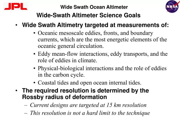
Wide-Swath Altimeter Science Goals. Wide Swath Altimetry targeted at measurements of: Oceanic mesoscale eddies, fronts, and boundary currents, which are the most energetic elements of the oceanic general circulation.

E N D
Wide-Swath Altimeter Science Goals • Wide Swath Altimetry targeted at measurements of: • Oceanic mesoscale eddies, fronts, and boundary currents, which are the most energetic elements of the oceanic general circulation. • Eddy mean-flow interactions, eddy transports, and the role of eddies in climate. • Physical-biological interactions and the role of eddies in the carbon cycle. • Coastal tides and open ocean internal tides. • The required resolution is determined by the Rossby radius of deformation • Current designs are targeted at 15 km resolution • This resolution is not a hard limit to the technique
Interferometric Measurement Concept • Conventional altimetry measures a single range and assumes the return is from the nadir point • For swath coverage, additional information about the incidence angle is required to geolocate • Interferometry is basically triangulation • Baseline B forms base (mechanically stable) • One side, the range, is determined by the system timing accuracy • The difference between two sides (Dr) is obtained from the phase difference (F) between the two radar channels. F = 2p D r/l = 2pB sin Q/l h = H - r sin Q
WSOA Science Rationale Topex Orbit, 2 Altimeters: 150km equatorial spacing, 10 day repeat Topex Orbit, 1 satellite, fixed yaw coverage Wide-Swath altimeter, 10 day repeat High resolution ocean topography measurements requires several coordinated nadir altimeters. A better coverage from a single platform can be obtained using an instrument which can image a swath instantaneously.
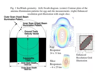
WSOA Intrinsic Resolution and Coastal Contamination Scenarios WSOA Swath • The WSOA down-linked data resolution is ~12km in the along-track direction and < 500m in the cross-track direction. • The data are are sampled every ~650m in the along-track direction Land 200 km 12 km ~650m < 500m Best case land contamination: only the range cells over land are affected, but range cells over the ocean are unaffected. Worst case land contamination: every resolution cell is affected by its fraction over the land.
WSOA on OSTM Mission Status • WSOA to be demonstrated as experimental mission on OSTM (Jason 2), contingent on: • Successful preliminary design review (Jan 03) • Obtaining a launch vehicle through the DOD Space Technology Program (STP) • Fitting in the Alcatel Proteus Bus without any performance impact to OSTM core mission • Final decision on WSOA inclusion in OSTM will probably occur in the second quarter of ‘03. • The WSOA demonstration mission on OSTM is not optimal for measuring geoid slopes • Yaw steering effects • However, the data are likely to be collected • We would like to explore geodetic applications for which the WSOA on OSTM data would be useful
OSTM Payload Concept GPSP antennas & front-end electronics (not shown) bus electronics include portions of GPSP and WSOA, and all of SIES WSOA deployable antenna and feed structure AMR antenna & electronics y WSOA two-sided deployable mast WSOA tip-mounted electronics x LRA mounted on nadir side of spacecraft z
WSOA on OSTM Error Budget Single Observation Error Budget Long wavelength (>100km) not relevant for geodesy Error budget based on 15 km height postings. Interferometric precision degrades by the area ratio for higher postings.
WSOA Precision vs Averaging Time • Since WSOA is in a repeat orbit, temporal averaging can be used to improve measurement precision • - Not all observation might be useful due to yaw steering Assuming all observations can be used Assuming 1/4 of all observations can be used
Fixed Yaw Coverage The number of observations in a 10 day period for WSOA on OSTM in fixed yaw mode is shown below. Fixed yaw coverage occurs for about ~22 day periods every ~60 days
Yaw Coverage Examples Optimal Coverage Cycle 25 Intermediate Coverage Cycle 23 Poor Coverage Cycle 32
Raw Measurement Geometry Along track direction Along track direction No Yaw 30 Degree Yaw (Figures not to scale in the range direction. Number of along-track looks also underrepresented) Although the along-track resolution is ~12 km, significant measurement overlap exists (~10 measurements/footprint) It is possible to attempt improving the resolution through inverse or deconvolution methods
A Simple Inversion Example • Assume 2 years worth of data collection • Use eigenvector filtering expansion for deconvolution (aka, EOF expansion) • This example assumes only data collecting in the ascending direction is used. • The solution of the optimal inversion using all data is still unexplored.
Comparison of Wide-Swath and Conventional Altimetry Wide-Swath Altimetry can be improved by using synthetic aperture techniques ( a la K. Raney, delayed Doppler altimeter). SAR WSOA scenario based on sea ice instrument proposed to NASA IIP in ‘02