Download
1 / 35
350 likes | 519 Views
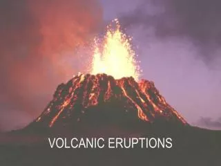
Four Classic Eruptions. Thera/Santorini - 1,620 BC Impact on Minoan Civilization; legend of Atlantis Vesuvius - 79 AD Detailed eyewitness accounts; well excavated ruins Krakatau - 1883 First instrumental data during major eruption Mt. Pelée - 1902

E N D
Four Classic Eruptions • Thera/Santorini - 1,620 BC • Impact on Minoan Civilization; legend of Atlantis • Vesuvius - 79 AD • Detailed eyewitness accounts; well excavated ruins • Krakatau - 1883 • First instrumental data during major eruption • Mt. Pelée - 1902 • >30,000 people killed in a single dome collapse event that generated dense block and ash flows
Volcanic Explosivity Index Eruption magnitude can either be measured based on the volume of lava ejected as tephra (ash and pumice) during an explosive eruption or the volume of lava extruded during an effusive eruption. VEI is a log scale and is empirically derived from historical data.
VEI Redux NB: Volumes are DRE (dense rock equivalent) Source: USGS
Deadliest Eruptions Since 1500 AD EruptionYearCasualtiesMajor Cause Nevado del Ruiz, Colombia 1985 25,000 Mudflows Mont Pelée, Martinique 1902 30,000 (29,025) Pyroclastic flows Krakatau, Indonesia 1883 36,000 (36,417) Tsunami Tambora, Indonesia 1815 92,000 Starvation Unzen, Japan 1792 15,000 (14,030) Volcano collapse, Tsunami Lakagigar (Laki), Iceland 1783 9,000 (9,350) Starvation Kelut, Indonesia 1586 10,000
Hellenic Arc - Regional Tectonic Setting NASA Space Shuttle Image November 13, 1995.
Numbers of Eruptions Eruption Frequency vs. VEI Similar frequency-magnitude behavior as observed for earthquakes. 1600-1982 Volcanic Deaths by Country Total = 238,000 Source: O. Melnik, Bristol
Location Map: Thera/Santorini, Greece NASA 1983 Shuttle Image Steep cliff faces define ancient caldera wall
Minoan Tephra - 1,650 BC Santorini Stratigraphy Basalts and Andesites Caldera Wall - formed during 21 ka event 50 m deposit of Minoan Tephra Photos: R. Decker
Kameni Islands Islands for after the caldera forming event that deposited the Minoan Tephra in 1,620 BC. Eleven lava flow eruptions since 197 BC, with most recent being in 1950 on Nea Kameni. Photo: R. Decker
Thera Summary • Thera was an important center of Minoan civilization. Eruption has been linked to Atlantis legend. • Plinian eruption and caldera collapse event at 1,620 BC. Contributed to the decline and ultimate demise of Minoan culture ~1,450 BC. • ~20 km3 of tephra was deposited in the sea and on adjacent islands • Large tsunamis were generated during the eruption, which affected coastal Mediterranean cities. • City of Akroteri was buried in 1-2 m of ash, but the population of ~30,000 was apparently evacuated prior to the eruption as no bodies were found during excavations.
Vesuvius, Italy Photo: C. Wood and NASA (above)
Primary Plinian & Sub-Plinian Eruptions of Somma-Vesuvius Name of the Eruption Age (years before present or AD) Codola 25000 Basal Pumices ( Sarno) 17000 Greenish Pumices 15500 Mercato (Ottaviano) 7900 Novelle no date available Avellino 3750 Pompeii 1900 (79 AD) Pollena 472 (AD) 1631 1631 (AD) Source: http://vulcan.fis.uniroma3.it/vesuvio/vesuviustext.html
79 AD Eruption Chronology - I • Greek and Roman scholars knew that Vesuvius was a volcano before 79 AD. • Feb. 5 AD 62, large earthquake jolted region that is now Naples. Common for region, so they were largely ignored. Events caused significant damage to Pompeii and Oplonti. Seneca stated that quakes lasted several days and weakened with time; he advocated for future hazard planning. • Pliny the Elder was the admiral of the roman fleet based in Misenum; he went to rescue people close the volcano and died (probably of a heart attack) once on shore near Stabiae (downwind of the eruption). • Pliny the Younger observed the eruption from Cape Misenum (~20 km away) and his letters form the basis of our detailed knowledge of a large explosive event and subsequent column collapse. “Plinian” eruptions are named in his honor.
The Route of Pliny the Elder Source: http://vulcan.fis.uniroma3.it/vesuvio/79_eruption.html
79 AD Eruption Chronology - Pliny’s Account • 1 PM on 24 August large “cloud” appeared in sky above Vesuvius. Reported to resemble a Mediterranean pine tree. • By nightfall, pumice fragments were falling on Stabiae. Earthquakes shook the area. • At dawn, sunlight was blocked from heavy ash fall. Sulphurous fumes were widespread. Lightning discharged within the ash cloud. • Tsunamis were generated by the earthquakes. Similar phenomena were described for the 1631 eruption. • Sky was completely blackened at Misenum. • Smooth cone of Vesuvius was revealed to be a stump, once ash had finally cleared.
79 AD Eruption Destroyed Pompeii Victim of a pyroclastic surge View of Vesuvius from Pompeii Photo: R. Decker (right) and Pompeii Museum (above)
Location Map, Krakatau LANDSAT Anak Krakatau - Emergent since 1927 Photo: R. Decker
Tsunami Inundation and Ship Tracks - 1883 Eruption All three ships survived the eruption despite their proximity.
Atmospheric Pressure Record at Batavia Gasworks Note multiple pressure pulses with largest at 10:15 AM local time, which caused the barometer to go offscale. Sound waves took ~5 m to reach Jakarata. First volcanic infrasound measurements! Discrete explosions or PFs?
Tide Gauge Record Tandjong Priok Arrival of tsunami Normal Tides ~2 hr wave period superimposed on tides.
1883 Krakatau Eruption Summary • Rakata volcano was the largest center on Krakatau Island prior to eruption. 800 m AMSL. • Krakatau and nearby islands were uninhabited. • Vague reports of eruptions on the islands in 1680 and 1681. • Frequent minor earthquakes in 1870’s near Sunda Straits. • Eruption sequence began suddenly on 20 May 1883. Audible explosions >150 km away. Ash deposited from air fall >500 km away. • Volcano quieted down by May 27. Close approach by ship yields reports of deafening noise. • Climatic eruption began on August 26 and continued until August 27, 1883. Several ships were in close proximity during eruption. • Most powerful explosion occurred 10:02 AM and was heard 4811 km away at Rodriguez Island in the Indian Ocean. Pressure transient of 1.45 mbar recorded in Tokyo. • Marine ignimbrite deposit is 40 m thick in places. ~20 km3 DRE erupted.
Lesser Antilles Island Arc and Caribbean Plate PRVI Caribbean Lesser Antilles MAT seismicity: epicenters < 30 km depth from USGS
Map of Devastation of May and August PFs at Mt. Pelée Volcano was active for weeks prior to major dome collapse. Citizens were forced to stay in town for local election that was to take place on May 11.