Download
1 / 1
10 likes | 94 Views
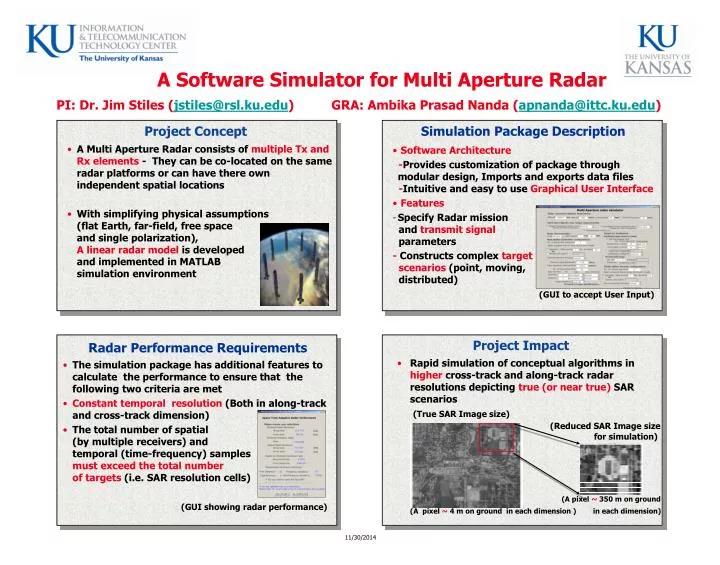
A Software Simulator for Multi Aperture Radar PI: Dr. Jim Stiles ( jstiles@rsl.ku.edu ) GRA: Ambika Prasad Nanda ( apnanda@ittc.ku.edu ) . Project Concept. Simulation Package Description.

E N D
A Software Simulator for Multi Aperture RadarPI: Dr. Jim Stiles (jstiles@rsl.ku.edu) GRA: Ambika Prasad Nanda (apnanda@ittc.ku.edu) Project Concept Simulation Package Description • A Multi Aperture Radar consists of multiple Tx and Rx elements - They can be co-located on the same radar platforms or can have there own independent spatial locations • With simplifying physical assumptions (flat Earth, far-field, free space and single polarization), A linear radar model is developed and implemented in MATLAB simulation environment • Software Architecture -Provides customization of package through modular design, Imports and exports data files -Intuitive and easy to use Graphical User Interface • Features • Specify Radar mission and transmit signal parameters - Constructs complex target scenarios (point, moving, distributed) (GUI to accept User Input) Project Impact Radar Performance Requirements • Rapid simulation of conceptual algorithms in higher cross-track and along-track radar resolutionsdepicting true (or near true) SAR scenarios (True SAR Image size)(Reduced SAR Image size for simulation) (A pixel ~ 350 m on ground (A pixel ~ 4 m on ground in each dimension ) in each dimension) • The simulation package has additional features to calculate the performance to ensure that the following two criteria are met • Constanttemporal resolution (Both in along-track and cross-track dimension) • The total number of spatial (by multiple receivers) and temporal (time-frequency) samples must exceed the total number of targets (i.e. SAR resolution cells) (GUI showing radar performance)