Download
1 / 4
40 likes | 111 Views
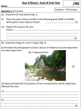
Year 10 Coasts – End of Unit Test Name: . /40. Duration – 40 minutes. Question 1 (25 marks). Study the OS map extract (fig. 1) Give the six figure grid reference of the car park south of the abbey in Whitby . …………………………………………….. [1]

E N D
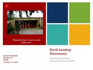
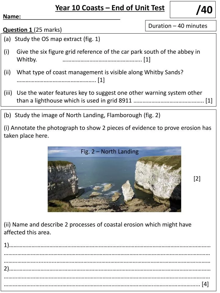
Year 10 Coasts – End of Unit Test Name: /40 Duration – 40 minutes Question 1 (25 marks) • Study the OS map extract (fig. 1) • Give the six figure grid reference of the car park south of the abbey in Whitby. …………………………………………….. [1] • What type of coast management is visible along Whitby Sands? …………………………………………….. [1] • Use the water features key to suggest one other warning system other than a lighthouse which is used in grid 8911 ……………………………………….. [1] Study the image of North Landing, Flamborough (fig. 2) (i) Annotate the photograph to show 2 pieces of evidence to prove erosion has taken place here. (ii) Name and describe 2 processes of coastal erosion which might have affected this area. 1)…………………………………………………………………………………………………………………………………………………………………………………………………………………………………………………………………….............………………………………………………………………………………….………2)…………………………………………………………………………………………………………………………………………………………………………………………………………………………………………………………………………………………………………………………………………..………………………... [4] Fig. 2 – North Landing [2]
(c) Explain 2 ways that geology affects the formation of coastal features/ landforms. 1)…………………………………………………………………………………………………………………………………………………………………………………………………………………………………………………………………….............………………………………………………………………………………….………2)…………………………………………………………………………………………………………………………………………………………………………………………………………………………………………………………………………………………………………………………………………..………………………... [4] There is a tombolo along the Dorset coast connecting Weymouth to the isle of Portland (figure 3). With the aid of a diagram describe and explain howthe tombolo has been formed. …………………………………………………………………………………………………………………………………………………………………………………………………………………………………………………………………….............………………………………………………………………………………….……………..…………………………………………………………………………………………………………………………………………………………………………………………………………………………………………………………………………………………………………………………………………..………………………... [4] Fig. 3 Chesil Beach CASETUDY: Coastal features. Name and locate an area of coast with distinctive coastal features: ………………………………………………………………………………………………………………………… Describe the location of the coast. Explain how coastal processes and geology have created the distinctive features. Include at least 3 developed ideas. …………………………………………………………………………………………………………………………………………………………………………………………………………………………………………………………………….............………………………………………………………………………………….…………………………………………………………………………………………………………………………………….
continued …………………………………………………………………………………………………………………………………………………………………………………………………………………………………………………………………….............………………………………………………………………………………….………………………………………………………………………………………………………………………………………………………………………………………………………………………………………………………………………………………………………………………………………………………………………………………………………….............………………………………………………………………………………….…………………………………………………………………………………………………………………………………[8] Question 2 (15 marks) • Study the wave diagram (fig. 4) • What type of wave is shown in fig. 4? …………………………………………….. [1] • Give one landform that might be created by this wave ….………………………………….. [1] Fig. 4- Diagram of a wave (b) Outline the advantages of using hard engineering strategies to protect the coastline…………………………………………………………………………………………………………………………………………………………………………………………………………………………………………………………………….............………………………………………………………………………………….……………………………………………………………………………………………………………………………………………………………………………………………………………………………………………………………………………….............………………………………………………………………………………….…………………………………………………………………………………………………………………………………[3]
(c) Study the article below (fig. 5) Using Figure 5,describe two social and two economic impacts of coastal flooding and erosion .……………………………………………….............………………………………………………………………………………….……………………………………………………………………………………………………………………………………………………………………………………………………………………………………………………………………………………………………………………………………………………………………………………………………….............………………………………………………………………………………….……………………………………………………………………………………………………………………………………………………………………………………………………………………………..…[4] Fig. 5 – Article about Coastal Erosion in Sydney (d) (i) Explain how freeze-thaw weathering causes rock on coastal cliffs to break up ………………………………………………………………………………………………………………………………………………………………………………………………………………………………………………………………………………………………………………………………………………………………………………………….............……………………………………………………………………………………………………………………………………………………………………………………………………………………………………………………………………………………………………………………………………………..[4] (ii) Outline the difference between coastal (marine) erosion processes and sub-aerial (weathering) processes ………….............……………………………………………………………………………………………………………………………………………………………………………………………………………………………………………………………………………………………………………………………………………..[2]