Download
1 / 1
10 likes | 90 Views
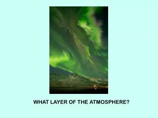
Using CALIPSO to Study the Influence of the Saharan Air Layer (SAL) on the Intensity of Tropical Cyclones Christopher Spells and M. Patrick McCormick, Hampton University. . What is the Saharan Air Layer?

E N D
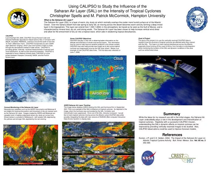
Using CALIPSO to Study the Influence of the Saharan Air Layer (SAL) on the Intensity of Tropical CyclonesChristopher Spells and M. Patrick McCormick, Hampton University  What is the Saharan Air Layer? The Saharan Air Layer (SAL) is a layer of warm, dry, dusty air which normally overlays the cooler more humid surface air of the Atlantic Ocean. Over the Sahara Desert from late spring to early fall, air moving across the desert becomes warm and dry forming a deep mixed layer in the troposphere. This layer can extend from 1,500-1,600m in the atmosphere, be traced as far west as the Gulf of Mexico, and is characterized by mineral dust, dry air, and strong winds. The Saharan Air Layer has been shown to help increase vertical wind shear and allow for the entrainment of dry air into a tropical wave, which aids in weakening tropical disturbances. CALIPSO Launched April 28, 2006, CALIPSO (Cloud-Aerosol Lidar and Infrared Pathfinder Spaceborne Observations) flies in formation with AQUA, CloudSat, PARASOL, and Aura around the earth to form the “A-Train” (Afternoon-Train). CALIPSO incorporates its own LIDAR (light detection ranging), which uses short pulses of light to probe through the atmosphere instead of radio waves. CALIPSO is providing global, vertically- resolved measurements of aerosol and cloud distribution, as well as their physical properties. CALIPSO is expected to have a lifetime of three years, CALIPSO is a joint project between Hampton University, NASA, and the French Government. Goal of Project The goal of this project is to use the vertically resolved CALIPSO data to research how the structure of tropical cyclones are effected when they interact with the SAL. The hope is to track tropical disturbances across the Atlantic, especially those forming off the coast of Africa, from formation to disintegration while monitoring the location of the SAL and dynamic conditions of the area such as vertical wind shear. Some CALIPSO Objectives CALIPSO will play a vital role in obtaining better information on the altitude and thickness of clouds and aerosol layers. This information may be used to help improve weather prediction and climate models. CALIPSO may also help provide new insight as to why some tropical cyclones are suppressed more by the SAL than others. Below is an example of how CALIPSO data looks. The first data was collected on June 7, 2006. GOES Saharan Air Layer Tracking The image below displays GOES tracking the SAL and Hurricane Erin in September • This is an example of the SAL’s influence on tropical cyclones. As depicted in the image, when the hurricane was surrounded by the SAL, formation and intensification was suppressed. Once out of the SAL, intensity increased. I would like to track tropical cyclones moving across the Atlantic using CALIPSO data while possibly integrating the data with new versions of McIDAS (Man computer Interactive Data Access System) to display data. Current Monitoring of the Saharan Air Layer Geostationary satellites such as the GOES instruments and Meteosat-8 are helpful for tracking the position and movement of dry air masses such as the Saharan Air Layer. Images created by GOES and Meteosat are valuable tools in helping understand where dry, dusty air comes from. Shown below is a product of Meteosat-8, with weaker SAL depicted by the yellows and stronger SAL depicted by the red coloring. Summary While the ideas for my research are still in the initial stages, the Saharan Air Layer undoubtedly plays a role in the development and intensification of tropical cyclones. Hopefully with a successful CALIPSO mission, understanding the SAL’s dynamic effects on tropical cyclones can be improved by providing vertically resolved images to be studied. Also, CALIPSO observations could be used to improve forecast models. References Dunion, J.P. and C.S. Velden, 2004: The Impact of the Saharan Air Layer on Atlantic Tropical Cyclone Activity. Bull. Amer. Meteor. Soc.Vol. 85 no. 3 353-365