Download
1 / 7

E N D
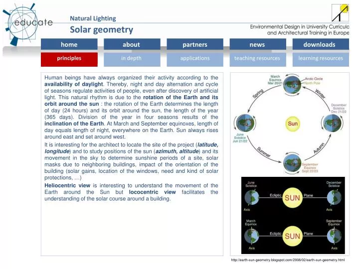
Human beings have always organized their activity according to the availability of daylight. Thereby, night and day alternation and cycle of seasons regulate activities of people, even after discovery of artificial light. This natural rhythm is due to the rotation of the Earth and its orbit around the sun : the rotation of the Earth determines the length of day (24 hours) and its orbit around the sun, the length of the year (365 days). Division of the year in four seasons results of the inclination of the Earth. At March and September equinoxes, length of day equals length of night, everywhere on the Earth. Sun always rises around east and set around west. It is interesting for the architect to locate the site of the project (latitude, longitude) and to study positions of the sun (azimuth, altitude) and its movement in the sky to determine sunshine periods of a site, solar masks due to neighboring buildings, impact of the orientation of the building (solar gains, location of the windows, need and kind of solar protections, …) Heliocentric view is interesting to understand the movement of the Earth around the Sun but lococentric view facilitates the understanding of the solar course around a building. Solar geometry http://earth-sun-geometry.blogspot.com/2008/02/earth-sun-geometry.html
Solar geometry EARTH – SUN RELATIONSHIP 1. Heliocentric view The earth is almost spherical in shape (~12 700 km in diameter). It revolves around the sun in a slightly elliptical orbit. The distance between the Earth and the Sun is about 150 million km. The full revolution takes 365.26 days and as the calendar year is 365 days, an adjustment is necessary. Ecliptic is the plane of the earth’s revolution. The Earth’s axis of rotation is tilted 23.45° from the normal to the plane of the ecliptic. Declination (DEC) is the angle between the plane of the earth’s equator and the ecliptic. It varies between +23.45° on June 22 (northern solstice) and -23.45° on December 22 (southern solstice). On equinox days (around September 22 and March 22), the Earth-sun line is within the plane of the equator and declination is null. “Latitude (LAT) of a point on the Earth’s surface is the angle subtended at the center of the earth between the plane of the equator and the line connecting the center with the surface point considered. By convention, southern latitudes are taken as negative.” extract from [1] Longitude (LONG) of a point on the Earth’s surface is the angle between the meridian passing by this point and the standard meridian (Greenwich), a meridian being a semi circle joining earth’s pole and crossing equator at right angle. Longitude is positive west and negative east. Latitude Longitude Sources : [1] Solar geometry, Steven V. Szokolay, PLEA notes http://geographyworldonline.com/tutorial/lesson1.html
Solar geometry 2. Lococentric view As human beings live on Earth, they consider that Earth is static and that it’s the rest of the Universe which revolves around it. Thereby, sun moves in the sky following a sun course, sky is an atmospheric vault and horizon is horizontal. Apparent position of the sun in this sky vault can be defined by two angles: its altitude and its azimuth. Altitude (ALT) is the angle measured, in a vertical plane, between the horizontal and the direction of the sun. Azimuth (AZI) is the angle measured, in a horizontal plane, between the North and the direction of the sun projected on the horizontal. In daylighting, we use commonly 0° for south, -90° for east and +90° for west and the converse for the southern hemisphere. 3. Time In daylighting studies, it’s generally solar time which is used. Solar time is defined by the position of the sun. At solar noon, sun is at the zenith. Due to rotation of the Earth, its orbit around the sun and its variation of speed, time noon to noon is not exactly 24 hours. Mean solar time is based on a fictional mean sun which travels at a constant rate throughout the year. The equation of time (EQT) is the difference between apparent solar time and mean solar time. Local mean time will be derived from solar time and equation of time [local mean time = solar time + EQT correction]. Finally standard time is the result of a synchronization of time for locations within a same time zone [standard time = solar time + EQT correction + LON correction + DST (daylight saving time)]. Equator North Pole Tropic of Cancer Equation of time Sources : Solar geometry, Steven V. Szokolay, PLEA notes http://www.mpoweruk.com/solar_power.htm http://www.astrocalculator.com/Sundial_SundialPlanar.htm http://cse.ssl.berkeley.edu/bmendez/ay10/2002/notes/lec4.html
Solar geometry GRAPHIC REPRESENTATION 1. Apparent sun-paths To understand and to use intelligently the influence of the sun on a site, it is essential to know, for each moment of a day, the position of the sun in the sky vault. Sun paths are an easy way to understand the course of the sun around a building and its influence. On equinox days, everywhere on the Earth, sun rises at east at 6.00 and set at west at 18.00 (solar time). During winter, day length is reduced and days are longer in summer, except at the equator where days have the same length all over the year. Moreover, at the equator, sun path is vertical while it is tilted in the same manner for the whole year according to the latitude. 2. Sun-path diagrams 3D apparent sun-paths can be projected on a 2D diagram in different manners. Polar diagrams and vertical diagrams are two interesting ways to represent sun course over the year. Moreover you can present information in solar time (sun at its zenith at noon) or in standard time (time on the clock). Sun-path diagrams can be create with different tools, easily available for students : an online tool of the University of Oregon for 2D diagrams (http://solardat.uoregon.edu/PolarSunChartProgram.html) - SketchUp and Ecotectsoftwares create sun path in 3D and facilitate the study of shadow castings. Brussels, 50.8N 4.3 E Singapore, 1.28N 103.85E Rio de Janeiro, 22.9S 43.18W Sources : http://solardat.uoregon.edu/PolarSunChartProgram.html
Solar geometry After locating the building (latitude, longitude), you can analysis sun course through sun path diagram. You will be able to determine how sun penetrates in the building, the impact of solar masks due to neighboring buildings and the shadows cast by your own building. You can also defining dimensions and kind of shading devices to minimize penetration of direct sun in your building. Sources : Architecture & Climat, UCL
Solar geometry To teach students about solar geometry and influence of the orientation of buildings, an artificial skies can be useful. An artificial sun or an heliodon will facilitate the understanding of the course of the sun and its penetration in building. Model scale could also be placed under the real sky to study the penetration of sun in the design space. Sources : Architecture & Climat, UCL
Solar geometry To create and understand sun paths: http://solardat.uoregon.edu/PolarSunChartProgram.html An interesting book: Szokolay S V. Solar Geometry, Passive and Low Energy Architecture International, Design Tools and Technique, note 1. University of Queensland, 1996.