Download
1 / 1
20 likes | 106 Views
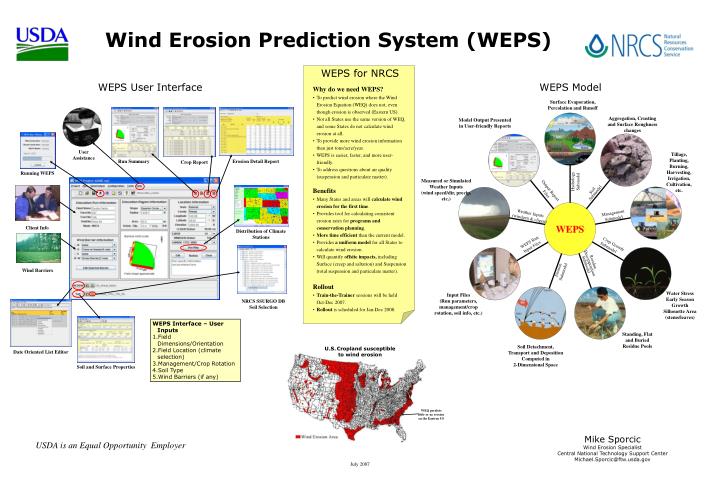
Surface Evaporation, Percolation and Runoff. Aggregation, Crusting and Surface Roughness changes. Model Output Presented in User-friendly Reports. Run Summary. User Assistance. Running WEPS. Measured or Simulated Weather Inputs (wind speed/dir, precip, etc.). Client Info. Wind Barriers.

E N D
Surface Evaporation, Percolation and Runoff Aggregation, Crusting and Surface Roughness changes Model Output Presented in User-friendly Reports Run Summary User Assistance Running WEPS Measured or Simulated Weather Inputs (wind speed/dir, precip, etc.) Client Info Wind Barriers Input Files (Run parameters, management/crop rotation, soil info, etc.) Date Oriented List Editor Standing, Flat and Buried Residue Pools NRCS SSURGO DB Soil Selection Soil Detachment, Transport and Deposition Computed in 2-Dimensional Space Distribution of Climate Stations Wind Erosion Prediction System (WEPS) WEPS for NRCS WEPS User Interface WEPS Model Why do we need WEPS? • To predict wind erosion where the Wind Erosion Equation (WEQ) does not, even though erosion is observed (Eastern US). • Not all States use the same version of WEQ, and some States do not calculate wind erosion at all. • To provide more wind erosion information than just tons/acre/year. • WEPS is easier, faster, and more user-friendly. • To address questions about air quality (suspension and particulate matter). Benefits • Many States and areas will calculate wind erosion for the first time. • Provides tool for calculating consistent erosion rates for programs and conservation planning. • More time efficient than the current model. • Provides a uniform model for all States to calculate wind erosion. • Will quantify offsite impacts, including Surface (creep and saltation) and Suspension (total suspension and particulate matter). Rollout • Train-the-Trainer sessions will be held Oct-Dec 2007. • Rollout is scheduled for Jan-Dec 2008. Erosion Detail Report Crop Report Hydrology Submodel Output Report Files Soil Submodel Management Submodel Weather Inputs (windgen & cligen) WEPS Run Input Files Crop Growth Submodel Residue Decomposition Submodel Erosion Submodel • WEPS Interface – User Inputs • Field Dimensions/Orientation • Field Location (climate selection) • Management/Crop Rotation • Soil Type • Wind Barriers (if any) U.S.Cropland susceptible to wind erosion Soil and Surface Properties WEQ predicts little or no erosion on the Eastern US Mike Sporcic Wind Erosion Specialist Central National Technology Support Center Michael.Sporcic@ftw.usda.gov USDA is an Equal Opportunity Employer July 2007