Download
1 / 1
10 likes | 84 Views
1. Objectives. 6. Los Angeles Area (Urban Land). 3. Regional Spectral Model (RSM). 5. Modern – Pre-settlement Run Comparisons. 2. Experiments. 7. Central Valley (Irrigated Cropland). 4. Land cover data sets. 8. Conclusions.

E N D
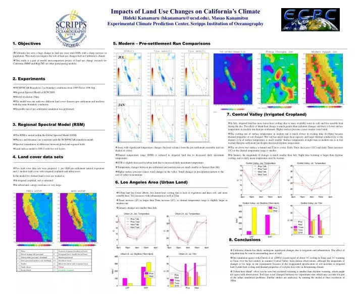
1. Objectives 6. Los Angeles Area (Urban Land) 3. Regional Spectral Model (RSM) 5. Modern – Pre-settlement Run Comparisons 2. Experiments 7. Central Valley (Irrigated Cropland) 4. Land cover data sets 8. Conclusions • In July, irrigated land has more latent heat cooling (due to more available water in soil) and less sensible heat during the day. The effect of latent heat change is much greater than radiation changes and there is lower surface temperature in modern run than pre-settlement. Higher surface pressure causes weaker zonal wind. • The cooling rate of surface temperature in modern run is much slower in evening time (4-10pm) because thermal properties of soil changed. Wet soil has much larger heat capacity and larger thermal conductivity so the diurnal cycle of surface temperature is much smaller. Surface temperature at night time in modern run is in fact warmer than pre-settlement run despite decreased daytime temperature. • The air above wet surface is humid and T2m is cooler. Daily Tmax decreases (11C) and daily Tmin increases (1C) so the diurnal temperature range is smaller. • In January, the magnitude of changes is much smaller than July. Night time warming is larger than daytime cooling, and so daily mean temperature may be warmer. • NCEP/NCAR Reanalysis 2 as boundary conditions from 1995 Oct to 1996 Sep. • Regional Spectral Model at ECPC/SIO. • Model resolution 25km. • The model was run with two different land cover datasets (pre-settlement and modern) with the same boundary conditions. • Ensemble run of pre-settlement simulation was performed. • California climate has likely undergone significant changes due to irrigation and urbanization. The effect of irrigation may be seen in surrounding areas as well. • Our simulation agrees with Christy et al. (2005)’s recent report of about 3 C cooling in Tmax and 3 C warming in Tmin over the last century in summer Central Valley from station observations, although the magnitude of changes is too large in our experiments because of the exaggerated specification of soil moisture in irrigated land. Latent heat cooling and thermal properties of soil play key roles in determining climate. • “Urban heat island” effect can be seen but nocturnal warming is smaller than daytime warming, which might not agree with observations. Soil type is not changed between two experiment runs which may account for part of the urban simulation problems. Further studies are underway by running the model at finer resolution of 10km. Impacts of Land Use Changes on California’s Climate Hideki Kanamaru (hkanamaru@ucsd.edu), Masao Kanamitsu Experimental Climate Prediction Center, Scripps Institution of Oceanography • California has seen a huge change in land use since mid-1800s with a sharp increase in population. This study investigates the role of land use changes had on California’s climate. • This study is a part of model intercomparison project of land use change research for California (MM5 and RegCM3 are other participating models). JUL JAN • The RSM is nested within the Global Spectral Model (GSM). • Physics and dynamics are consistent with the NCEP/NCAR reanalysis model. • Spectral formulation of difference between global and regional fields. • Land surface model is OSU2 with two soil layers. • Areas with significant temperature changes (beyond variance from the pre-settlement ensemble run) are shaded in colour. • Diurnal temperature range (DTR) is reduced in irrigated land due to decreased daily maximum temperature. • DTR is slightly increased in urban land due to increased daily maximum temperature. • Temperature changes between pre-settlement and modern runs are much smaller in January than July. • Higher surface pressure causes wind changes in the valley. Small changes in precipitation pattern to the east of valley in mountains • Two land cover data sets were prepared. 1: pre-1890 pre-settlement natural vegetation and 2: modern land cover with irrigated croplands and urban areas. In the model two distinct land covers are treated as: • In irrigated cropland, soil is saturated. • In urban land, canopy resistance is very large. • Urban land has lower albedo, less latent heat cooling due to lack of vegetation and drier soil, and more sensible heat. Tsfc increases with urbanization as well as T2m. • Tmax increase (2C) is larger than Tmin increase (1C), so diurnal temperature range is slightly larger in modern run. • January changes are smaller than July.