Download
1 / 26
260 likes | 402 Views
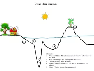
IV. DIVISIONS IN THE OCEAN (see diagram pg. 9). A. CONTINENTAL 8% of the surface area of the world ocean is the continental margin canyons in the ocean may be found at the mouths of rivers. Google Earth. B. DEEP OCEAN. Trace profile from book. Seafloor Features: Deep Ocean.

E N D
IV. DIVISIONS IN THE OCEAN(see diagram pg. 9) • A. CONTINENTAL • 8% of the surface area of the world ocean is the continental margin • canyons in the ocean may be found at the mouths of rivers. Google Earth
B. DEEP OCEAN • Trace profile from book
Seafloor Features: Deep Ocean • seamounts - underwater volcanoes 500 m to 1000 m high • flat-topped ones are called guyots • volcanic features (buoyed up by hot rock, lava) • abyssal hills - features around 200 m high • pervasive on seafloor • volcanic AND tectonic in origin - still debated
V. TOOLS FOR MEASURING • A. SHALLOW- SCUBA self contained underwater breathing apparatus. • peripheral vision 180 degrees down to 80 degrees "tunnel vision" • magnification of 33% 12 ft. looks 8 ft. away • color distortion with depth (pg. 53 in library oceanography book) • pressure increase w/ depth 1 atm per 10m 33 ft.
Bends and Nitrogen Narcossis • SOLVE PROBLEMS USING PRESSURE CHANGES
B. DEEP OCEANshow video from unitedstreaming about surveying the ocean floor • -----old--- rope and weight • ---new--- echo sounding • SONAR (sound navigation and ranging) Used in lake Erie to monitor the erosion of land from the Ohio side. Echo Sounding Navy 1922 • Read Bathymetry lab
TEST TOPICS • Bathymetry, Plate tectonics, Oceanographers, Oceans characteristics, plot longitude and latitude, • Scuba and pressure calculations, • pgs. 1-15 • Geographic features, Continental Drift • REVIEW PRACTICE SHEET