Download
1 / 1
10 likes | 132 Views
Development of a Small Remotely Piloted Vehicle for the Collection of Normalized Difference Vegetative Index Readings. Dr. Randy R. Price, Goutam Nistala Department of Biological and Agricultural Engineering Louisiana State University AgCenter. LSU BAE. Objectives

E N D
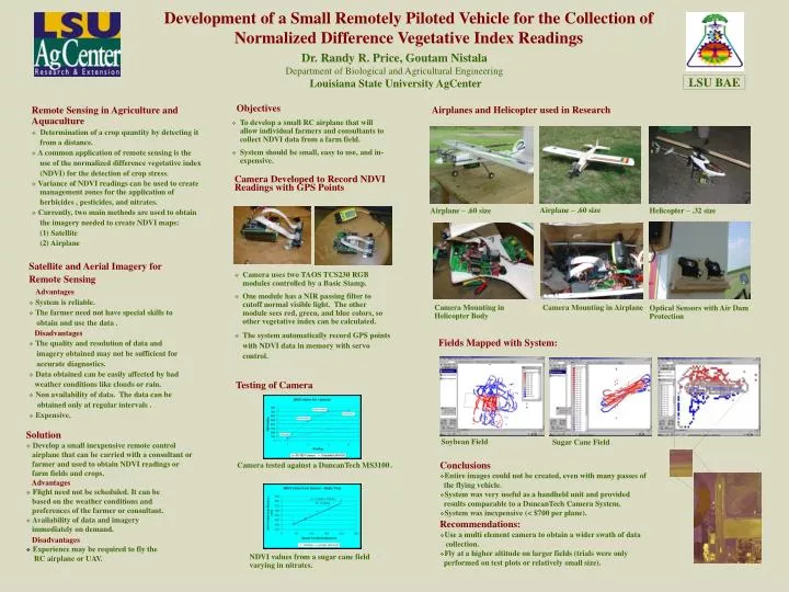
Development of a Small Remotely Piloted Vehicle for the Collection of Normalized Difference Vegetative Index Readings Dr. Randy R. Price, Goutam Nistala Department of Biological and Agricultural Engineering Louisiana State University AgCenter LSU BAE Objectives • To develop a small RC airplane that will allow individual farmers and consultants to collect NDVI data from a farm field. • System should be small, easy to use, and in-expensive. Airplanes and Helicopter used in Research Remote Sensing in Agriculture and Aquaculture • Determination of a crop quantity by detecting it from a distance. • A common application of remote sensing is the use of the normalized difference vegetative index (NDVI) for the detection of crop stress. • Variance of NDVI readings can be used to create management zones for the application of herbicides , pesticides, and nitrates. • Currently, two main methods are used to obtain the imagery needed to create NDVI maps: (1) Satellite (2) Airplane Camera Developed to Record NDVI Readings with GPS Points Airplane – .60 size Airplane – .60 size Helicopter – .32 size • Satellite and Aerial Imagery for Remote Sensing Advantages • System is reliable. • The farmer need not have special skills to obtain and use the data . Disadvantages • The quality and resolution of data and imagery obtained may not be sufficient for accurate diagnostics. • Data obtained can be easily affected by bad weather conditions like clouds or rain. • Non availability of data. The data can be obtained only at regular intervals . • Expensive. • Camera uses two TAOS TCS230 RGB modules controlled by a Basic Stamp. • One module has a NIR passing filter to cutoff normal visible light. The other module sees red, green, and blue colors, so other vegetative index can be calculated. • The system automatically record GPS points with NDVI data in memory with servo control. Camera Mounting in Helicopter Body Camera Mounting in Airplane Optical Sensors with Air Dam Protection Fields Mapped with System: Testing of Camera • Solution • Develop a small inexpensive remote control airplane that can be carried with a consultant or farmer and used to obtain NDVI readings or farm fields and crops. Advantages • Flight need not be scheduled. It can be based on the weather conditions and preferences of the farmer or consultant. • Availability of data and imagery immediately on demand. Soybean Field Sugar Cane Field • Conclusions • Entire images could not be created, even with many passes of the flying vehicle. • System was very useful as a handheld unit and provided results comparable to a DuncanTech Camera System. • System was inexpensive (< $700 per plane). Camera tested against a DuncanTech MS3100. • Recommendations: • Use a multi element camera to obtain a wider swath of data collection. • Fly at a higher altitude on larger fields (trials were only performed on test plots or relatively small size). • Disadvantages • Experience may be required to fly the RC airplane or UAV. NDVI values from a sugar cane field varying in nitrates.