Download
1 / 1
10 likes | 113 Views
Are sounding profiles from geostationary satellites helping us yet?. 1 NOAA/NESDIS/STAR/CORP/Advanced Satellite Products Branch (ASPB) Madison, WI 2 Cooperative Institute for Meteorological Satellite Studies (CIMSS) – University of Wisconsin-Madison 3 IM Systems Group, Inc. Rockville, MD

E N D
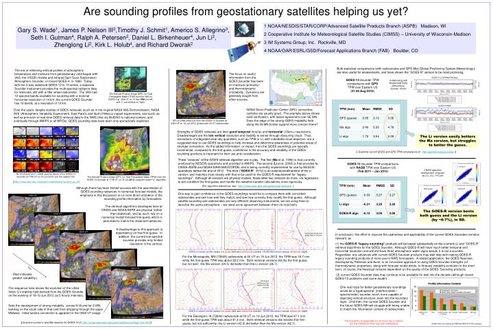
Are sounding profiles from geostationary satellites helping us yet? 1 NOAA/NESDIS/STAR/CORP/Advanced Satellite Products Branch (ASPB) Madison, WI 2 Cooperative Institute for Meteorological Satellite Studies (CIMSS) – University of Wisconsin-Madison 3 IM Systems Group, Inc. Rockville, MD 4 NOAA/OAR/ESRL/GSD/Forecast Applications Branch (FAB) Boulder, CO Gary S. Wade1, James P. Nelson III2,Timothy J. Schmit1, Americo S. Allegrino3, Seth I. Gutman4, Ralph A. Petersen2, Daniel L. Birkenheuer4, Jun Li2, Zhenglong Li2, Kirk L. Holub4, and Richard Dworak2 Bulk statistical comparisons (with radiosondes and GPS-Met (Global Positioning System-Meteorology)) are also useful for assessments, and have shown the “GOES-R” version to be most promising. The era of retrieving vertical profiles of atmospheric temperature and moisture from geostationary orbit began with VAS, the VISSR (Visible and Infrared Spin Scan Radiometer) Atmospheric Sounder, on board GOES-4, in 1980. Today, with the 3-axis stabilized GOES-12 to 15 series, a separate Sounder instrument provides the multi-spectral radiance data for retrievals, still with a filter wheel radiometer. The VAS had 12 spectral bands available for sounding with a nominal horizontal resolution of 14 km; the current GOES Sounder has 19 bands, at a resolution of 10 km. The focus on useful information from the GOES Sounder has been on moisture (primarily) and thermodynamic (in)stability. Dynamics are generally sought from other sources. GOES-13 Sounder TPW comparisons with GPS TPW over Eastern US (01-29 Aug 2012) Collaborating with NOAA/OAR ESRL (Birkenheuer, Gutman, Holub) The Derived Product Image (DPI) for Total Precipitable Water (TPW) from the VAS on GOES-5 at 1348 UT on 10 Apr 1984 (on left, with 11 µm window on right). NOAA Storm Prediction Center (SPC) convective outlooks are usually good. The example above shows solid verification, with lesser agreement over SE MN. Does the edge of the strong GOES instability field along the IA-MN border support more concern there? Over the years, despite studies of GOES retrievals (such as in the original NASA VAS Demonstration, NASA AVE (Atmospheric Variability Experiment), East Pacific and Gulf of Mexico impact experiments, and such) as well as provision of real-time GOES retrieval data to the NWS (first via McIDAS to national centers, and eventually through AWIPS to all WFOs), GOES sounding data have been only sporadically exploited. DPI of Lifted Index (LI) from the GOES-13 Sounder at 2346 UT on 18 Jun 2012, plotted with 00 UT radiosondes. Strengths of GOES retrievals are their good temporal (hourly) and horizontal (10km+) resolutions. Disadvantages are the low vertical resolution and inability to sense through obscuring cloud. Thus, animations of integrated clear sky quantities, such as TPW or LI, with imbedded cloud depiction, are a suggested way to use GOES soundings to help increase and determine awareness of potential areas of stronger convection. As the added information, or impact, from the GOES soundings are typically incremental, compared to the first-guess, confidence in the accuracy and reliability of the GOES sounding products is important for their use and consideration. The Li version easily betters the Ma version, but struggles to better the guess. [ Examine current GOES and GPS TPW comparisons at: http://gpsmet.noaa.gov/ssec/] Three “versions” of the GOES retrieval algorithm are in play. The first (Ma et al, 1999) is that currently produced by NESDIS operations and provided in AWIPS. The second (Li et al, 2008) is that provided by CIMSS-ASPB and NOAA/StAR/SMCD/OPDB, and is being currently implemented for use by NESDIS operations before the end of 2012. The third (“GOES-R”, 2012) is an extension/refinement of the Li version, and matches most closely with that to be used for the GOES-R requirement for “legacy soundings”. Although all versions are physical models, these latter two versions do more, via regression, to pre-condition the first-guess and handle the radiative transfer calculations more rigorously. GOES-13 Sounder TPW comparisons with RAOB TPW over Eastern US (Feb 2011 – Jan 2012) CIMSS algorithm development progress by J.Li, Z.Li, Y-K.Lee Li version All 18 infrared and 1 visible spectral bands of the GOES-13 Sounder at 1746 UT on 18 Jun 2012 over the eastern US. The Derived Product Image (DPI) for Total Precipitable Water (TPW) from the GOES-13 Sounder at 1746 UT on 18 Jun 2012, using the newer “Li” algorithm. [http://cimss.ssec.wisc.edu/goes/rt/viewdata.php?product=ge_all] [For algorithm references, see: http://cimss.ssec.wisc.edu/goes/rt/exp-work.php .] Although there has been limited success with the assimilation of GOES sounding radiances in numerical forecast models, the emphasis in this discussion is on more direct utilization of the sounding profile information by forecasters. GFS guess GOES-R One way to gain confidence in the GOES soundings would be to compare them with coincident radiosondes and see how well they match, and see how correctly they modify the first-guess. Although satellite sounding and radiosondes are very different observing instruments, we are using them to describe the same atmosphere – we need some agreement between them (to trust both). 1800 UT The retrieval algorithms developed here at CIMSS and NOAA/ASPB are physical (rather than statistical), and as such, rely on a numerical model forecast first-guess which is perturbed to match the observed radiances. The GOES-R version bests both guess and the Li version (by ~6-7%), in SD. 2100 UT A disadvantage to this approach is dependency on that first-guess. In addition, the current low-spectral sounder provides only limited resolution in the vertical. 0000 UT Insufficient drying (but better than Li version) In conclusion, this effort to improve the usefulness and applicability of the current GOES Sounders remains relevant, as (1) the GOES-R “legacy sounding” products will be based substantially on the (current) Li and “GOES-R” retrieval algorithms for the GOES Sounder. Although GOES-R will have much better temporal and horizontal resolution and will still have three atmospheric water vapor bands, it is not a sounder. Regardless, any advances with current GOES Sounder products may well help with making GOES-R legacy sounding products of more use to NWS forecasters. A related application, the GOES Nearcast, developed by Petersen and Aune, is an innovative approach to using GOES Sounder strengths (of thermodynamic properties), along with forecast model winds, to forecast instability evolution in the short term; of course, the Nearcast remains dependent on the quality of the GOES. Sounding products. (2) current GOES Sounder data may continue to be available for well into the decade (although recent GOES-13 problems cast some doubt!). 0300 UT GOES Li-version profile versus first-guess (left) and radiosonde (center) ; GOES Ma-version versus radiosonde (right). For the Minneapolis, MN (72649) radiosonde at 00 UT on 19 Jun 2012, the TPW was 18.7 mm while the first-guess TPW was about 28.2 mm. Both retrieval versions did dry the first-guess, but not well; the Ma version (24.5) did better than the Li version (26.7). 0600 UT Time (Red indicates greater instability.) Insufficient moistening (but better than Ma version) One real hope for better geostationary soundings would be a hyperspectral (interferometer / spectrometer) sounder, much more capable of depicting vertical structure, even into the boundary layer. Until then, the current GOES Sounder and the future GOES ABI will struggle with being unable to match the information content of radiosondes. The sequence here shows the evolution of the Lifted Index (LI) stability field derived from the GOES Sounder, on the evening of 18-19 Jun 2012 (at 3 hourly intervals). Note the development of strong instability across N IA and far S MN, building on the south side of that cold front dropping through the upper Midwest. Initial severe convection is apparent in the 0546 UT image. GOES Li-version profile versus first-guess (left) and radiosonde (center) ; GOES Ma-version versus radiosonde (right). For the Davenport, IA (72649) radiosonde at 00 UT on 19 Jun 2012, the TPW was 47.1 mm while the first-guess TPW was about 41.2 mm. Both retrieval versions did moisten the first-guess, but not sufficiently; the Li version (42.9) did better than the Ma version (42.1). The first author is responsible for all errors; the co-authors are only thanked for their help and contributions. [ Examine current Li and Ma versions for GOES-14 at: http://cimss.ssec.wisc.edu/goes/realtime/eus/begin-eus.html] (GOES-Sndr-rets-helping-yet-NWAmtg-MSN-20121001-gsw.ppt)