Download
1 / 25
250 likes | 422 Views
Unit 5: Russia and the Republics. Physical Geography. Landforms and Resources. Northern Landforms. This region can be broken down into 4 areas: Northern European Plain West Siberian Plain Central Siberian Plateau Russian Far East. Northern Landforms. Northern European Plain

E N D
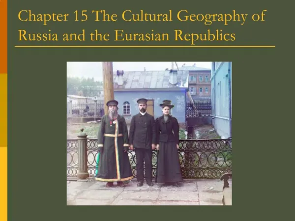
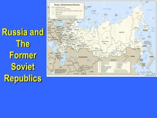
Unit 5: Russia and the Republics Physical Geography
Northern Landforms • This region can be broken down into 4 areas: • Northern European Plain • West Siberian Plain • Central Siberian Plateau • Russian Far East
Northern Landforms • Northern European Plain • Lowland area • 1,000 miles from western border to Ural Mountains • Chernozem-“black earth”, very fertile soil • Lots of agriculture in this area • 290 million people inhabit this land • Big Cities: Moscow, St. Petersburg, Kiev (Ukraine)
Northern Landforms • West Siberian Plain • Ural Mountains and Yenisey River • Because this area is tilted northward, rivers flow toward Arctic Ocean • Eurasia??
Northern Landforms • Central Siberian Plateau and Russian Far East • Central Siberian: • Plateaus: 1,000-2,000 feet are common • Yenisey and Lena Rivers • Russian Far East • Volcanic ranges • Kamchatka Peninsula (120 volcanoes, 20 actives) • Sakhalin and Kuril islands
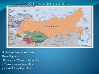
Southern Landforms • Caucasus and Other Mountains • Black and Caspian seas • Border between Russia and Transcaucasia • Armenia, Azerbaijan, Georgia • Tian Shan is part of a huge mountainous region farther east • Central Asia-Kazakhstan, Kyrgyzstan, Tajikistan, Turkmenistan, Uzbekistan • Ranges in this area are so high, stops moist air from reaching the areas beyond the mountains
Southern Landforms • Turan Plain • lowland • Caspian Sea to mountains and uplands of Central Asia • Syr Darya and Amu Darya are the 2 major rivers of the area • Kara Kum and KyzylKum plains
Rivers and Lakes • Drainage Basins and Rivers • Drainage Basins-area drained by a major river and tributaries • Arctic Ocean, Caspian Sea, Pacific Ocean, Baltic Sea, Black Sea, Aral Sea basins • Arctic basin is the larges • Rivers: Ob, Yenisey, Lena drain 3 million sq. mi.
Rivers and Lakes • Lakes • Caspian and Aral Seas • Both are saltwater lakes • Caspian is largest inland sea in the world • Aral has lost about 80% of its water volume since the 1960s due to irrigation • Lake Baikal • Deepest lake in the world • Mile depth, 400 miles long • 20% of Earth’s freshwater • Thousands of plants and animals live in the lake • Only species of freshwater seal lives here
Regional Resources • Issues with managing the many resources of this region • Corruption • Environmental issues • Coal, iron ore, other metals • Oil and natural gas • Timber • Hydroelectric power
Regional Resources • Harsh climates, difficult terrain, and large distances make management unstable • Many resources are located in Siberia • Mining, oil, natural gas production has caused severe damage to the environment • Dams and thermal pollution have damaged plant and animal habitats
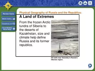
Varying Climates • Major Climate Regions • Humid continental and subarctic dominate the area • High latitude and impact of mountains • Because the land is so large, sea/ocean influence doesn’t impact the majority of the region • Continentality
Varying Climates • Distance from sea can impact precipitation and temperature • Siberia: highs of 50 degrees, lows of -90 degrees • Weather impacts life
Varying Climates • Warmer climates do exist: southeastern areas • Semiarid and desert • Transcaucasia: moist air from Mediterranean Sea created a subtropical climate zone. • Before ethnic cleansing issues, resorts here were a popular tourist destination
Vegetation Regions • Tundra • Mosses • Lichens • Low shrubs • Forest • Taiga-largest forest on earth, contains mostly coniferous trees • Animals: fox, vermin, bear, elk, wolves
Vegetation Regions • Steppe • Grassland • Southern Ukraine through northern Kazakhstan • Fertile soil: grain • Desert • Plains of west and central areas of Central Asia • Kara Kum and KyzylKum
Shrinking Aral Sea • Gets most of its water from Amu Darya and Syr Darya • Irrigation projects took water out of these rivers and towards agriculture • Sea is beginning to evaporate • Effects of Agriculture • Pesticides and fertilizers on cotton farms were picked up by runoff and brought into streams/rivers • Killing much plant and animal life in the area • Diseases for people: cancer, respiratory issues, dysentery, typhoid, hepatitis
“Wild East” • Traveling through Siberia was dangerous and slow during the 19th century • Trans-Siberian RR-linked Moscow to Pacific port of Vladivostok
“Wild East” • Trans-Siberian RR • 5,700 mi long • 7 time zones • 1891-1903 • 70,000 workers • 77 million cubic feet of land, 100,000 acres of forest cleared