Download
1 / 64
670 likes | 1.02k Views
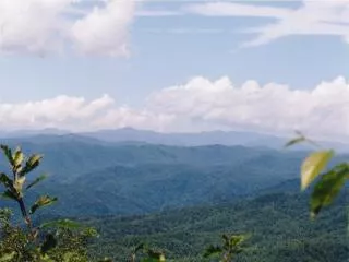
Landscape Ecosystem Perspective 1. Background on ecosystem classification 2. Ecological variation among ecosystems 3. Applications for resource mgt. Xeric oak/blueberry ecosystem ( 35 o 01' 30 "N, 83 o 00'25"W ). Xeric chestnut oak/mountain laurel ecosystem ( 35 o 01' 17 "N, 82 o 59'13"W ).

E N D
Landscape Ecosystem Perspective 1. Background on ecosystem classification 2. Ecological variation among ecosystems 3. Applications for resource mgt
Xeric chestnut oak/mountain laurel ecosystem (35o01'17"N, 82o59'13"W)
Mesic hardwoods/bloodroot ecosystem (35o01'31"N, 83o00'20"W)
Mesic hemlock/rhododendron ecosystem (35o02'14"N, 82o49'09"W)
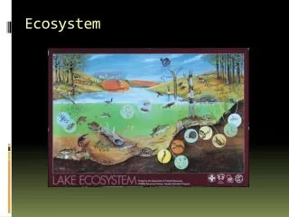
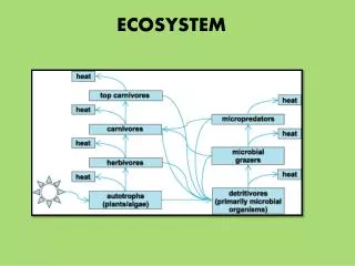
Soils, geomorphology, and biota vary from place to place across a landscape • These 3 factors interact at a given spot on the landscape to produce an ecosystem • Landscape ecosystem – volumetric unit of the landscape • Ecosystem classification – grouping similar sites into ecosystem types
Ecosystem classification identifies interrelationships within and among geomorphology, soils, and vegetation Vegetation Geomorphology Soils Ecosystem Type Ecological Properties
Terrestrial Ecosystem Survey Integrates climate, geology, soils, and vegetation
Soil catena MA; http://nesoil.com/plymouth/catena.gif
Classification is a data reduction or information reduction technique • This works because combos of similar geomorphology, soils, and veg reoccur across a landscape • Continuous vs. classification • An ecosystem type has ecological properties (e.g., soil texture), which differ among ecosystems
Notes on multifactor and multivariate: simply mean many factors or variables • Classification has long history in ecology – EC emphasizes interactions and geomorphology/soils • Geomorphology/soil relatively stable – e.g., topographic features, soil texture • Vegetation useful, but not essential
Identifying key environmental variables Southern Appalachian Mountains solum = A + B horizon
EC not a panacea; yet practical tool • Examples of EC systems – US FS TES, NRCS site types, research-grade EC • EC provides framework for studying how properties vary among ecosystems • Here are some examples:
Landscape ecosystem control over tree mortality Longleaf pines in SE USA – in very moist, waterlogged ecosystems, rooting depth is restricted. Trees more susceptible to wind damage (uprooting) due to shallow root system But lightning mortality important on upland xeric sites!
From a Michigan project of the federally endangered Kirtland’s warbler in jack pine forests Findings: We noted significant differences in climate, physiography, soil, and vegetation between 10 landscape ecosystems at the ecological level of landforms. Moreover, jack pine height growth differed significantly among the 10 ecosystems, and the landforms exhibited marked differences in the timing of initial colonization and duration of occupancy by the warbler. Ecosystems favoring jack pine growth - those with a warmer microclimate or higher-quality soil - were typically colonized first but had the shortest duration of occupancy, while colder, drier, and less fertile ecosystems were colonized later but had longer durations of occupancy.
Archaeological Resources • Upper Michigan: Locations of historical logging camps can be predicted using LEC • Eastern white pine was desirable timber species in late 1800s – logging camps located by pines and by water for transporting logs • Michigan Archaeologist 43:87-102.
1920-2660 m elevations 6300-8700 ft Ponderosa pine, Gambel oak, aspen Entisols, Inceptisols, Alfisols, Mollisols Slope gradients mostly < 10%
60 trees/ha 132 trees/ha
Methods • 102, 0.05-ha plots sampled in 2003 (66 core plots) • 55, 500, 513, 523, 536, 551, 558, 570, 582, 585, and 611 soil types • Geomorphology, soils, plant communities • Cored 2 dominant, open-grown pines of pre-1875 origin • Seed bank samples • 0-15 and 15-50 cm soil samples analyzed for texture, gravel content, organic C, total N, pH, CaCO3 equivalent, and water-holding capacity • Multivariate and univariate analyses
Ecosystem classification Cluster analysis and ordination 10 ecosystem types on 66 plots Ecosystem types internally similar in environment and vegetation characteristics Black cinders/Phacelia (558) Red cinders/Bahia (513) Clay basalt/Gutierrezia (523) Xeric limestone/Bouteloua (500) Mesic limestone/mixed flora (536) Xeric basalt/Muhlenbergia (551, 570) Rocky basalt/Sporobolus (570, 582, 585) Mesic basalt/Festuca (551, 570, 582, 585) Aspen/Lathyrus (611) Park/Symphyotrichum (55)
Black cinders/Phacelia UTM 452794E, 3905543N Elevation 2007 m Low upper soil fertility
Ponderosa pine seedling growth in 19201 Cinders Clay 1 Haasis, F.W. 1921. Relations between soil type and root form of western yellow pine seedlings. Ecology 2:292-303.
Xeric basalt/Muhlenbergia UTM 441833E, 3917442N silt: 41% (0-15 cm) organic C: 1.2% total N: 0.09% C4 mountain muhly Mesic basalt/Festuca UTM 432074E, 3903341N silt: 53% (0-15 cm) organic C: 2.2% total N: 0.14% C3 Arizona fescue
Red cinders/Bahia UTM 446730E, 3915773N Elevation 2326 m High gravel content, sandy loam soils, slow tree growth UTM 452716E, 3898173N Elevation 2079 m
Rocky basalt/Sporobolus UTM 445788E, 3877037N Elevation 7252 ft
Lupinus argenteus Lathyrus lanszwertii Vicia americana 0-15 cm soil total N: 0.26% next highest ecosystem: 0.15% Populus/Lathyrus UTM 424674E, 3886663N Elevation 2215 m
Age 50-150 yr mean annual diameter increment of pre-1875 origin ponderosa pine Means without shared letters differ at P < 0.05 (Fisher’s LSD) Error bars are 1 SD
Plant species richness Means without shared letters differ at P < 0.05 (Fisher’s LSD) Error bars are 1 SD