Download

1 / 18
180 likes | 275 Views
Introduction to NASA’s Modern Era Retrospective-analysis for Research and Applications: MERRA. NASA Remote Sensing Training Geo Latin America and Caribbean Water Cycle capacity Building Workshop Colombia, November 28-December 2, 2011. ARSET

E N D
Introduction to NASA’s Modern Era Retrospective-analysis for Research and Applications: MERRA NASA Remote Sensing Training Geo Latin America and Caribbean Water Cycle capacity Building Workshop Colombia, November 28-December 2, 2011 ARSET AppliedRemoteSensingEducationandTraining A project of NASA Applied Sciences
Objectives • To Present: • A brief overview of MERRA Water Products • Examples of analysis and visualization of weather • events and climate variability For details see http://gmao.gsfc.nasa.gov/research/merra/
NASA Water Products • Rain • Snow/Ice • Water Vapor • Clouds • Soil Moisture • Ground Water • Snow/Ice • Rain, Clouds, Water Vapor • Soil Moisture • Evaporation/Transpiration • Run off Water Cycle Components Products in red - derived from satellite measurements Products in blue - derived from atmospheric/land surface models, such as MERRA, in which satellite measurements are assimilated or combined
Modeling of the atmosphere-Land-Ocean Systems • Models use laws of physics in terms of mathematical equations to represent atmosphere, ocean, land systems and changes occurring in them in space and time • Models apply these mathematical equations, on • horizontal and vertical grids by using numerical • methods • Models use observations to represent the atmosphere ocean-land system at a given time to deduct how the system will evolve over space/time • Models ‘parameterize’ physical processes based on physical/statistical/empirical techniques derived or verified by using observed quantities
Modeling of the atmosphere-Land-Ocean Systems • Modeling of water-related processes is complex due to presence of water in gaseous, liquid, and solid forms in the atmosphere-ocean-land system • Rigorous validation with observations and model to • model inter-comparisons are conducted to assess • uncertainties in models MERRA precipitation comparison with other models
What is Reanalysis? • A technique to produce multiple climate variables in which past observations are combined with a model • Past observations of basic meteorological data such as temperature, wind speed, and pressure are analyzed and interpolated onto model grids • 3-D forecasting model is initialized and constrained with the observations • The model simulations provide many climate variables which are not observed, for example moisture flux • The model simulations also provide more frequent (hourly, 6-hourly) output than observations
MERRA Reanalysis Data • Input: Standard Meteorology • Temperature, Pressure, Wind, Moisture, Radiance • Chemistry: Ozone; Aerosol and Carbon under development • Irregularly distributed in space and time • Output • Clouds and their properties • Water Cycle • Energy Budget from the top of atmosphere to the surface of the Earth • Global coverage at regular frequency From: Michael Bosilovich, NASA-GSFC-GMAO
Blends the vast quantities of observational data with output data of the Goddard Earth Observing System (GEOS) model [1979-present] MERRA Current satellite coverage assimilated in MERRA
Observations used in Reanalysis • MERRA Focuses on historical analyses of the water cycle on a broad • range of weather and climate time scales (hours to years) and places • the NASA satellite observations in a climate context • Technologies change; Instrument life cycle From: Michael Bosilovich, NASA-GSFC-GMAO
Reanalysis July 2011 (850 hPa) Relative Humidity (fraction) • Strengths – The processed data are globally continuous in space and time, and provide meteorological and climatological relevant fields • Weakness – Earth system models represent the human knowledge of how the world works Eastward Winds (m/s) From: Michael Bosilovich, NASA-GSFC-GMAO
MERRA Water Products Temporal Resolution: Monthly Spatial Resolution: 1.25°x1.25° and 42 vertical levels 3-dimensional Parameters Units • Specific Humidity Kg/Kg • Relative Humidity Fraction • Cloud Fraction Fraction • Spatial Resolution: 2/3°x1/2° • Surface Rainfall Rate Kg/m2/s • Surface Evaporation Kg/m2/s • Cloud Top Pressure and Temperature hPa and K • Vertically Integrated Water Vapor Kg/m2 2-dimensional Parameters
MERRA Water Products Temporal Resolution: Hourly Spatial Resolution: 1.25°x1.25° and 42 vertical levels 3-dimensional Parameters Units • Specific Humidity Kg/Kg • Relative Humidity Fraction • Cloud Fraction Fraction • Cloud liquid and ice water mixing ratio Kg/Kg • Spatial Resolution: 2/3°x1/2° • Surface Rainfall Rate Kg/m2/s • Snow Mass Kg/m2 • Snow Cover Fraction • Snow Depth m • Surface Snowfall Rate Kg/m2/s • Surface Evaporation Kg/m2/s • Cloud Top Pressure and Temperature hPa and K • Vertically Integrated Water Vapor, • cloud liquid and ice water contentKg/m2 2-dimensional Parameters
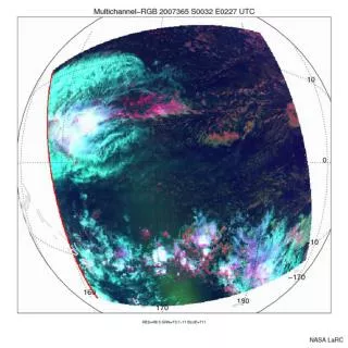
MERRA for Weather Hurricane Irene August 27 0 GMT Sea Level Pressure Total Atmospheric Moisture Northward Wind Eastward Wind
MERRA Climate data MSU data is assimilated, so the apparent correlation is expected From: Michael G. Bosilovich, NASA-GSFC-GMAO
MERRA Data: Regional Climate Variability Snow Depth Snow Depth Snow Mass
MERRA products Can be downloaded from http://mirador.gsfc.nasa.gov by a keyword search. Also, can search by time and location/region
MERRA Image Products • Numerous atmospheric and surface parameters • available from http://disc.sci.gsfc.nasa.gov/giovanni
Retrospective-Analyses • Value added merger of many types of observations with the latest Earth systems models • Development of reanalyses lead to improved models and observations • As the observing system improves, uncertainties decrease • Weather, climate, climate variation in both research and applied decision making • Some climate trend study can be made, significantly more research and development is needed From: Michael Bosilovich, NASA-GSFC-GMAO