Download
1 / 26
280 likes | 426 Views
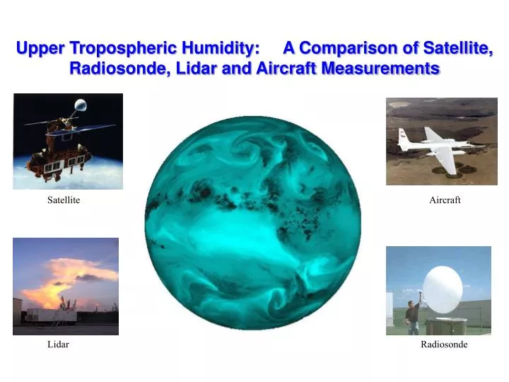
Upper Tropospheric Humidity: A Comparison of Satellite, Radiosonde, Lidar and Aircraft Measurements. Satellite. Aircraft. Lidar. Radiosonde. Collaborators. Rich Ferrare et al., NASA/LaRC John Goldsmith, DOE/LANL Barry Lesht, DOE/ANL Larry Milosevich, NCAR Frank Schmidlin, NASA/GSFC

E N D
Upper Tropospheric Humidity: A Comparison of Satellite, Radiosonde, Lidar and Aircraft Measurements Satellite Aircraft Lidar Radiosonde
Collaborators Rich Ferrare et al., NASA/LaRC John Goldsmith, DOE/LANL Barry Lesht, DOE/ANL Larry Milosevich, NCAR Frank Schmidlin, NASA/GSFC Bill Smith et al., NASA/LaRC Dave Tobin et al., Univ. of Wisconsin Dave Turner, DOE/PNNL David Whiteman et al., NASA/GSFC
Objective To assess of the accuracy of current measurements of upper tropospheric water vapor. Assuming: a) There is no perfect observation of upper tropospheric water vapor. b) We should assess the consistency of different measurements, rather than attempting to validate against a specific benchmark. c) Satellites can provide a common reference for comparing disparate measurements to assess their relative consistency.
Change in Water Vapor at 2xCO2: GFDL GCM Increase in tropopause RH amplifies wv feedback by ~10% Most change attributable to increase in saturation vapor pressure
What do IR “water vapor” radiances measure? • The 6.7 mm radiances are sensitive to relative humidity averaged over a deep layer of the upper troposphere (~200-500 hPa). * Use satellite 6.7 mm Tb to provide a common, stable benchmark for intercomparing other measurements.
Step 2: Transform both observed and simulated Tb into Upper Tropospheric relative Humidity (UTH) ln (UTH p0/ cosq) = a + b T6.7 (1) * Use UTH translation to interpret Tb comparison. 1 K error in Tb equals ~10% relative error in UTH. How do you compare satellite measurements with a water vapor profile? "Profile-to-Radiance" Comparison Procedure Step 1: Insert lidar/sonde moisture profile (and coincident sonde temperature profile) into radiative transfer model. * Compare observed and forward-simulated Tb.
UTH Transformation 6.7 mm Tb 0 UTH 100 % High Cloud
Global Comparison of Satellite and Radiosondes (Soden and Lanzante 1996)
Radiosonde – Satellite: Upper Tropospheric Humidity 10 (09184) -12 (10384) 15 (09393) 10 (09486) 14 (09548)
Temporal Comparisons of Upper Tropospheric Water Vapor Radiosonde – Satellite: Upper Tropospheric Humidity
Satellites provide a common reference for intercomparing different UTWV measurements and assessing their relative consistency
Radiosonde Humidity Profiles Vaisala RS80 VIZ Carbon Hygristor Frostpoint Chilled Mirror Radiances NASA/LaRC Airborne Interferometer (NAST-I) GOES 6.7 mm Imager ARM Water Vapor Intensive Observation Periods The Atmospheric Radiation Measurement (ARM) Program has conducted a series of Water Vapor IOPs over their Central U.S. field site: 1996 WV IOP, 1997 WV IOP, 1999 Lidar IOP, 2000 WV IOP, 2000 AFWEX • Lidar Humidity Profiles: • ARM /CART Raman Lidar (CARL) • GSFC Scanning Raman Lidar (SRL) • NASA/LaRC DIAL Lidar (LASE)
Measurement Intercomparison: Radiosonde cloud cloud Radiosondes are drier by ~20-30% relative to satellite.
Measurement Intercomparison: Lidars cloud cloud Raman (CARL, SRL) and DIAL (LASE) lidar agree to within ~10%.
Measurement Intercomparison: NAST-I NAST-I intereferometer and GOES-8 radiances agree to within ~1 K.
Bias Summary Uncorrected sondes are ~30% drier than GOES in the upper trop (~20% drier than lidar). Temp-lag corrections can reduce this bias to ~10% wrt lidar. Lidars, aircraft intereferometer, and satellite agree to ~10%. Radiosondes Lidars & NAST
Vertical Structure of Biases Direct assimilation of satellite radiances offers potential to greatly improve the radiosonde humidity profiles in the upper troposphere.
Summary Satellite IR measurements can provide an effective tool for intercomparing upper tropospheric humidity from different instruments. Vaisala RS80 radiosondes exhibit a systematic dry bias relative to both satellite and lidar measurements. Existing ARM radiosonde corrections were ineffective in the upper troposphere, however some new corrections show promise (i.e., Miloshevich). Direct assimilation of satellite radiances offers potential to improve the radiosonde humidity profiles in the upper troposphere when other corrections are not available (e.g., for historical records).
Vertical Structure of Biases Existing ARM correction methods improve total column water vapor, but have little impact on the upper troposphere.