Download
1 / 1

E N D
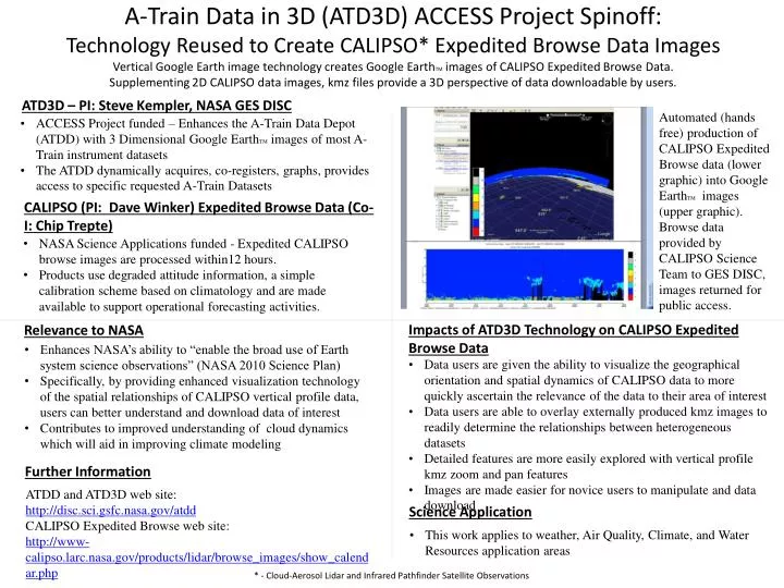
A-Train Data in 3D (ATD3D) ACCESS Project Spinoff:Technology Reused to Create CALIPSO* Expedited Browse Data ImagesVertical Google Earth image technology creates Google EarthTM images of CALIPSO Expedited Browse Data. Supplementing 2D CALIPSO data images, kmz files provide a 3D perspective of data downloadable by users. ATD3D – PI: Steve Kempler, NASA GES DISC Automated (hands free) production of CALIPSO Expedited Browse data (lower graphic) into Google EarthTM images (upper graphic). Browse data provided by CALIPSO Science Team to GES DISC, images returned for public access. • ACCESS Project funded – Enhances the A-Train Data Depot (ATDD) with 3 Dimensional Google EarthTM images of most A-Train instrument datasets • The ATDD dynamically acquires, co-registers, graphs, provides access to specific requested A-Train Datasets CALIPSO (PI: Dave Winker) Expedited Browse Data (Co-I: Chip Trepte) • NASA Science Applications funded - Expedited CALIPSO browse images are processed within12 hours. • Products use degraded attitude information, a simple calibration scheme based on climatology and are made available to support operational forecasting activities. Impacts of ATD3D Technology on CALIPSO Expedited Browse Data Relevance to NASA • Enhances NASA’s ability to “enable the broad use of Earth system science observations” (NASA 2010 Science Plan) • Specifically, by providing enhanced visualization technology of the spatial relationships of CALIPSO vertical profile data, users can better understand and download data of interest • Contributes to improved understanding of cloud dynamics which will aid in improving climate modeling • Data users are given the ability to visualize the geographical orientation and spatial dynamics of CALIPSO data to more quickly ascertain the relevance of the data to their area of interest • Data users are able to overlay externally produced kmz images to readily determine the relationships between heterogeneous datasets • Detailed features are more easily explored with vertical profile kmz zoom and pan features • Images are made easier for novice users to manipulate and data download Further Information ATDD and ATD3D web site: http://disc.sci.gsfc.nasa.gov/atdd CALIPSO Expedited Browse web site: http://www-calipso.larc.nasa.gov/products/lidar/browse_images/show_calendar.php Science Application • This work applies to weather, Air Quality, Climate, and Water Resources application areas * - Cloud-Aerosol Lidar and Infrared Pathfinder Satellite Observations