Download
1 / 5
50 likes | 142 Views
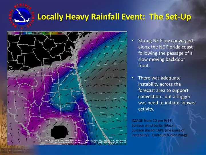
Strong NE Flow converged along the NE Florida coast following the passage of a slow moving backdoor front. There was adequate instability across the forecast area to support convection…but a trigger was need to initiate shower activity. IMAGE from 10 pm 9/16: Surface wind barbs (black)

E N D
Strong NE Flow converged along the NE Florida coast following the passage of a slow moving backdoor front. • There was adequate instability across the forecast area to support convection…but a trigger was need to initiate shower activity. • IMAGE from 10 pm 9/16: • Surface wind barbs (black) • Surface Based CAPE (measure of instability): Contours/Color Image Locally Heavy Rainfall Event: The Set-Up
Strong NE Flow converged along the NE Florida coast following the passage of a slow moving backdoor front. • There was the potential for heavy rainfall in convection due to high moisture content and slow storm motion. • Image: 00Z 9/17 Jacksonville Sounding Locally Heavy Rainfall Event: The Set-Up
Locally Heavy Rainfall Event: The Events KJAX 0.5 Z at 03:02Z 9/17 KJAX 0.5 Z at 00:58Z 9/17 KJAX 0.5 Z at 22:59Z 9/16 • Two distinct bands of convection developed late last night. The first band extended N-S from northern Columbia county to eastern Alachua. • It is possible that as the line inland intensified and created locally low pressure, NE convergence was increased along the coast and thus intensified convection across Duval and northern St. Johns counties.
IMAGE: Storm Total Precipitation (inches) from the Valdosta Radar (KVAX) from last nights rainfall event. • Widespread 3-4 inches (yellow) • Locally 6-10 inches (white & purple) Locally Heavy Rainfall Event: The Results
IMAGE: Storm Total Precipitation (inches) from the Valdosta Radar (KVAX) from last nights rainfall event. • Ground Truth reports confirm much of Arlington received 7-8 inches of rainfall • Locations near Jacksonville Beach received around 9 to 9.5 inches. Locally Heavy Rainfall Event: The Results