Download
1 / 14
140 likes | 291 Views
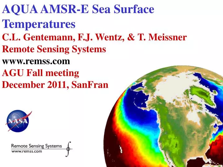
AQUA AMSR-E Sea Surface Temperatures C.L. Gentemann, F.J. Wentz, & T. Meissner Remote Sensing Systems www.remss.com AGU Fall meeting December 2011, SanFran. Aqua AMSR-E SSTs.

E N D
AQUA AMSR-E Sea Surface Temperatures C.L. Gentemann, F.J. Wentz, & T. Meissner Remote Sensing Systems www.remss.com AGU Fall meeting December 2011, SanFran
Aqua AMSR-E SSTs • Sea Surface Temperature (SST) is vital to coastal and marine spatial planning, global weather prediction, climate change studies, search and rescue, and ecosystem based management. • SST is derived from measurements taken by numerous satellites carrying infrared and microwave radiometers, and measured from moored buoys, drifting buoys, and ships • AQUA AMSR-E was the first well-calibrated global microwave PMW with the necessary channels to determine SST
PMW satellites • TRMM TMI (1998 – present) • No 7 GHz • <40 deg latitude • AQUA AMSR-E (6/2002 – 10/2011) • 7 & 10 GHz (plus others) • Global • WindSAT (2/2003 – present) • 7 & 10 GHz (plus others) • Global • Difficult new instrument, so data just becoming available
A new age of coverage AMSR-E MODIS
Climate Stability • Water Vapor is a greenhouse gas – IR SST are susceptible to biases due to water vapor • Volcanic aerosols, Saharan Dust, & Asian Dust events result in cool biases (minimized in more advanced instruments)
AMSR-E data Sea Ice Wind Speed Precipitation Cloud SST Water Vapor
Conclusions • AMSR-E data accurate • Coverage better than IR • Lower spatial resolution than IR (25 km) • Global data from 2002 - present • Data at www.remss.com • Future instruments • GCOM-W AMSR2 (Feb 2011) • NASA GPM GMI (no 7 GHz, <60 lat, 2014)
Formal Induced Input Errors • Use RTM to determine errors for each retrieval Errors for input variables (Tbs, SST_OI, Wind Direction) Sensitivity Analysis Formal Input-Induced Error (FIIE) Additional Information about errors (algorithm errors, influence of rain, etc Error Merging Modified Input-Induced Error (MIIE)
AMSR-E SST • Adaptive algorithms to reduce RFI, land • Current PMW • TRMM TMI (no 7 GHz, <40 lat) • WindSAT (EXCELLENT!) • National Satellite Oceanic Application Service, SOA, China HaiYang (10/2011) • Future instruments • GCOM-W AMSR2 (Feb 2011) • NASA GPM GMI (no 7 GHz, <60 lat, 2014)
Validation of AMSRE SSTs FIIE (Formal Errors) AMSRE V7 - Buoys