Download
1 / 33
330 likes | 430 Views
Design Review Week 15: Global Positioning System Device fo r the Visually Imparied. GPS : Lydia Hlebasko Daniel Schrader Nenad Zezelj. Team Introduction. Office of the Dean of Students. Mission statement:

E N D
Design Review Week 15: Global Positioning System Device for the Visually Imparied GPS: Lydia Hlebasko Daniel Schrader Nenad Zezelj
Office of the Dean of Students Mission statement: To “develop and implement services, activities, and opportunities that complete the student experience and enhance their adjustment to and participation in college life.” Office of Dean of Student
Disability Resource Center(DRC) A division of ODOS Provides accommodations to students who have various impairments. Working with Natasha Baebler, PD Program Specialist, as our Project Partner. Office of Dean of Student
GPS-DVIGlobally Positioning System Device for the Visually Impaired Lydia Hlebasko Daniel Schrader Nenad Zezelj
Introduction Visually impaired students may have trouble getting used to campus GPS-DVI is a portable guide, so to speak User-centered (and very user-friendly) design Preprogrammed routes “I’m lost!” button GPS-DVI Office of Dean of Student
Introduction Daniel Schrader – Senior – Physics/Robotics Nenad Zezelj – Sophomore – EET Lydia Hlebasko – Sophomore – Computer Science GPS-DVI Office of Dean of Student
Community Need A device that allows the visually impaired to familiarize themselves with campus without the need of a guide. Project was conceived many years ago. Restarted in Fall 2008 The students did not have an equivalent device that they could use. GPS-DVI Office of Dean of Student
Project Scope This project targets new Purdue students who are visually impaired. We will not be providing an orientation service for those who are not visually impaired. Auditory tour guide GPS-DVI Office of Dean of Student
Design Overview Stakeholders: Office of Dean of Students EPICS Students who would benefit from this project. Overview and description: Provide auditory directions to the user along a specified route. The route and output audio files will be stored on a removable media card and then accessed by the program. GPS-DVI Office of Dean of Student
Initial State of Project Clutter and inaccessibility of parts with the original satchel. No easy way to test the program Had to walk around and lose valuable time Cryptic and inconsistent comments in the code inhibited understanding Lack of clarity and organization in main code GPS-DVI Office of Dean of Student
Current State of the Project Redesigned satchel Visual Basic GPS Simulator New GPS module Hardware research Added “I’m Lost” feature Serial comm. for route info Main GPS-DVI system (code) GPS-DVI Office of Dean of Student
Operational Overview GPS-DVI Office of Dean of Student
Design Overview: Main System Takes input (nodes) from a file and interprets the data Uses this data to determine next waypoint, when to provide audio cues, and what audio file to play “I’m lost” feature gives distance and cardinal direction to next waypoint GPS-DVI Office of Dean of Student
Main System Currently the main system is nearing the end of the detailed design phase. All main features are present, some fully functional. The next steps will be improving efficiency, hardware consolidation, generating dynamic routes GPS-DVI Office of Dean of Student
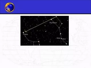
“I’m Lost” Algorithm Refreshes the distance to the next waypoint Determines cardinal direction with help from formula obtained from: http://williams.best.vwh.net/avform.htm Plays general audio cues such as “Next waypoint is…” “400 feet…” “to the East” GPS-DVI Office of Dean of Student
Route Files Simple text file containing route info Stored on memory card on MP3 player Read via serial communication Developed standard format Latitude, longitude, threshold, audio file aaaa.aaaabbbbb.bbbbcccTrackXX System parses out each piece of data into separate variables GPS-DVI
Challenges Experienced technical difficulties that caused some significant delays Formula for cardinal direction is a complex trigonometric creature Distance algorithm proved sensitive to changes in seemingly unrelated areas of code Significant, persistent difficulties in retrieving route info from MP3 player GPS-DVI
Visual Basic GPS Simulator GPS-DVI
Design Overview: VB Simulator GPS-DVI Office of Dean of Student
GPS-DVI Visual Basic GPS Walking Simulator • Goal: Simulate “walking” across Purdue Campus • Programming Language Used: VB.net • Majority of Program Developed by Professor Richardson
Other Project Information GPS-DVI
Bill of Materials: Spring 2010 GPS-DVI Items Purchased ($100) Future Purchases ($100) • GPS: ($60) • Bag: ($20) • Misc. Electronics: ($20) • Printed Circuit Board: ($50) • Speaker: ($10) • Misc. Electronics: ($40) Office of Dean of Student
Success Criteria The successful device will be able to guide a visually impaired user through multiple routes across campus. Deliverables for a successful project: Functional prototype of the GPS-DVI unit Write a basic manual of directions for the device. Success can be measured by how reliably the unit guides the user Further improvement can be made by integrating the device with the ICM project. GPS-DVI Office of Dean of Student
Goal and Constraints Goal: Develop a prototype that has all major functionality. Constraints: Limited interaction with the user. Limited memory for the device. Limited battery life. GPS-DVI Office of Dean of Student
Conclusion for GPS-DVI GPS-DVI
Conclusion Basic functionality of GPS-DVI system is in place Simulation programs dramatically speed up development More routes will enrich the usefulness of the system Going forward, keep user-friendly design in mind GPS-DVI Office of Dean of Student
Discussion of Future Plans Have the program read in a list of nodes and output with understandable directions. Integrate the ICM project with the GPS-DVI project so that a user can create routes that the device will be able to interpret and respond Initial delivery date: Spring 2010 GPS-DVI Office of Dean of Student
Efficiency Streamline code Refine number of variables and size of variables Combine functions Minimize amount of computation required GPS-DVI
Hardware Consolidation Separate boards means more complexity, potential points of failure, and a plethora of wires. Eventual solution is to consolidate all of the boards into a printed circuit board. GPS-DVI
Dynamic Route Generation Create a “sea of waypoints” on campus. Develop a program that can compute the best route from one location to another through the waypoints. Allow user to select conditions such as shortest route, scenic route, avoid major intersections, etc. GPS-DVi