Download
1 / 16
160 likes | 166 Views
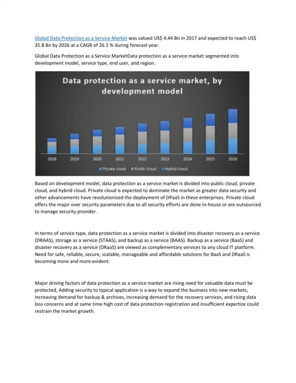
This project aims to implement an innovative bathymetry data service using the evolving IHO S-100 data standards. The project will focus on solving issues related to survey turn-around time, meeting the needs of multiple stakeholders, operational preparedness for e-Navigation and autonomous shipping, as well as data integrity and security. The service will be cloud-based and bathymetry-focused, utilizing the latest open geospatial approaches and computing techniques. The pilot project will demonstrate the ability to provide a subscription-based service for bathymetry data in specific geographic areas of interest. The data will be accessible through a rich API and will be stored in a scalable and open relational database.

E N D
INTRODUCTION • A project is underway with the CHS to implement an innovative bathymetry data service that will demonstrate the value of the evolving IHO S-100 data standards • The project team is made up of CHS (HO), Teledyne CARIS (hydro software) and PRIMAR (RENC) • It will focus on the latest technological approaches
KEY OBJECTIVES • What problems are we trying to solve? • The survey to bridge turn-around time • Efficiency and complexity of meeting the needs of multiple stakeholders • Operational preparedness for e-Navigation and autonomous shipping • Data integrity and security
KEY OBJECTIVES • What approaches are required for success in the market place? • Service orientated • Cloud based • Bathymetry focused then charts • Latest open geospatial approaches • Latest computing techniques
KEY OBJECTIVES • What are the financial considerations and economic factors? • Learn from the ENC distribution market place • Understanding the bathymetry value chain • Provide innovative service based cost models • Base pricing on type of user and application
Subscribe to data THE HIGH LEVEL CONCEPT Data Request Bathy DB On Premise database S-100 Data Services cell based GeoStore Incoming Surveys and other Sources of Bathy Data 3rd party Access Point Bathymetry Cloud Store Bathy S-102 RESTful approach Currents S-111 Tides S-104 Latest Data Updates ENC S-101 S-100 Data Area ECDIS PPU / ECS Marine SDI
PILOT PROJECT OVERVIEW • This pilot will allow CHS, Teledyne CARIS and PRIMAR to demonstrate its ability to provide a service that consumers of bathymetry data can subscribe to • Data will be available in pre-determined geographic areas of interest • By bathymetry data we mean coverages, vector features and S-102 products • CARIS will develop a cloud hosted datastore located outside of the CHS infrastructure • CARIS will develop a rich API providing 3rd party access to the datastore 3rdparty • PRIMAR will expand its existing applications to provide a store front to access S-102 bathymetry data AWS
TECHNICAL APPROACH - CARIS • DATA INPUT • CHS Bathymetry residing in a on-premise Bathy DataBASE will be replicated to the Cloud datastore • A Cloud based BDB Server instance and BDB Admin tools will be used for the upload during the Pilot • New datasets will be published automatically to the cloud through scripts that run on schedule • DATA ACCESS - NATIVE • Data access will be via a documented REST API using JSON (some XML may be used in Pilot only) • The Native API will provide additional efficiency over the OGC API • This API will be used by partners like PRIMAR for the purpose of building B2B solutions • The following services will be supported • Coverage, Feature, Object, Catalogue, Authentication • DATA ACCESS - OGC • This API will provide access to the data for broader uses through open standards • The following services will be supported • WCS, WFS, CSW
TECHNICAL APPROACH - CARIS • CATALOGUE SERVICE • The catalogue service can be used to discover bathymetry data • Based on a geographic area of interest or data updated within a specific time period • Or a combination of both requests • client applications can then notify users what changed • CLOUD STORAGE • The data will be stored in a highly scalable “open” relational database • The schema will use the OGC simple features model
PROJECT DELIVERABLES • Three demo will act as project milestones • This will also enable all parties to discuss project progress with broader community • Demo 1 - Demonstration of CHS bathymetry via CARIS GeoStore in PRIMAR Web application • This will show how bathymetry in the datastore is available alongside ENC data for discovery • Demo 2 - Demonstration of CHS bathymetry via CARIS GeoStore in PRIMAR 3D viewer • This is a compelling use case of S-102 data showing the potential for e-Navigation • Demo 3 - Demonstration of full data flow from CHS database to client facing Web application • This will show how new bathymetry in the CHS database is automatically uploaded to the datastore and is available for users who have subscribed to that area
TIMELINE Three milestones to demonstrate increasing capability of the bathymetry data service Milestone 3 Full data flow from CHS database to end-users via Web application Milestone 1 CHS bathymetry in CARIS GeoStore and PRIMAR Web application Milestone 2 CHS bathymetry in CARIS GeoStore and PRIMAR 3D viewer
S102 CREATION AND UPLOAD CARIS Cloud Outdated Cells Production BDB Server Historical DB Combine & Export BAG
DEMO 1 – EXPLANATION (1) CHS bathymetry in CARIS Bathy DataBASE as incoming surveys (2) CHS bathymetry as S-102 cells in CARIS GeoStore on Amazon (3) CHS bathymetry in PRIMAR Viewer
S-102 CREATION AND UPLOAD PROCESS • CHS Production database: Contains thousands of datasets, with hundreds overlapping • Outdated Cells repository: Contains the info about which tiles have been outdated • Creation and Upload process currently scheduled task, multiple processes run in parallel to increase performance • The outdated tiles are ordered by level and the date which they were outdated • Priority is given to the higher resolution tiles and those outdated the longest • For each outdated tile we create a new combined surface using the data from the Production database and CHS combine rules to create a BAG populated with metadata • The updated tile is then loaded onto CARIS Cloud • They are currently also loaded into an archive for history tracking