Download
1 / 2
20 likes | 127 Views
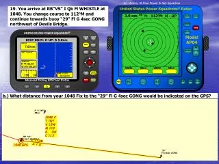
DEST PAN1: H-UP: R 5.0nm. SPEED. 2.90nm. DIST TO NEXT. 2.20nm. POSITION. N 41 o 24.60’. W 071 o 56.10’. 30. 240. TIME TO DIST. 00:45:31. TYPE. NAME. FIND. NAV. LOCATION. ½. 3.0 nm. 033 o M. H - UP. ½. RR. 3.0 nm. 129 o M. H - UP. RR. DEST MEM1: H-UP: R 5.0nm. 1151 GPS.

E N D
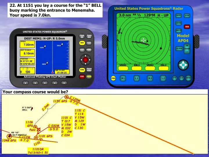
DEST PAN1: H-UP: R 5.0nm SPEED 2.90nm DIST TO NEXT 2.20nm POSITION N 41o24.60’ W 071o56.10’ 30 240 TIME TO DIST 00:45:31 TYPE NAME FIND NAV LOCATION ½ 3.0 nm 033oM H - UP ½ RR 3.0 nm 129oM H - UP RR DEST MEM1: H-UP: R 5.0nm 1151 GPS SPEED Map Save Save Delete 7.00nm WAYPOINT MEM1 MEM1 DIST TO NEXT 8.10nm COMMENTS 1106 GPS POSITION N 41o21.38’ C 032M S 5.0 W 070o46.25’ N41o21.377’ W070o46.253’ NIBW DB29 VSRW Pan1 DISTANCE BEARING 0 130 TIME TO DIST 8.03nm 129M 01:09:25 1101 GPS 1101 VRM1 EBL1 VRM2 EBL2 VRM1 EBL1 VRM2 EBL2 22. At 1151 you lay a course for the “1” BELL buoy marking the entrance to Menemsha. Your speed is 7.0kn. Your compass course would be? C 129M S 7.0 2.2nm R “2 S&P” BELL 1151 C T 114 V 15W M 129 D 1W C 130 1101 C T 017 V 15W M 032 D 2W C 034 RB “VS” I Qk Fl WHISTLE C 112M S 7.0 1048 GPS 1101DR 7x13/60=1.51
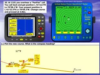
½ 3.0 nm 129oM H - UP RR DEST MEM1: H-UP: R 5.0nm SPEED 7.00nm DIST TO NEXT 5.50nm POSITION N 41o22.90’ W 070o53.40’ VRM1 EBL1 VRM2 EBL2 0 130 TIME TO DIST 00:47:08 MENU DEST MEM1: H-UP: R 5.0nm ! ! GAYH GAYH SPEED 12.0nm DIST TO NEXT 2.64nm ½ 3.0 nm 129oM H - UP RR 1151 GPS POSITION N 41o22.40’ Map Select W 070o49.50’ 0 130 TIME TO DIST 00:13:12 NEAREST WAYPOINT LIST NAME BRG DIST 1106 GPS DBG1GAYHDB29VSRW MEM1 NI1 NIBW 252M 212M 273M 338M 129M 001M 319M 1.52 1.55 1.90 2.30 2.64 3.39 4.61 C 033M S 5.0 VSRW MEM1 DB29 DBG1 Pan1 1228 1101 GPS 1213 1101 VRM1 EBL1 VRM2 EBL2 Art Mollica, St Paul Power & Sail Squadron 23. At 1213 the fog lifts, you increase your speed to 12kn. At 1228 you check your progress with two GPS nearest waypoint distance arcs. Plot the 1228 fix. C 129M S 7.0 1213DR 7x22/60=2.56 2.2nm RW ”NA” Mo(A)WHISTLE R “2 S&P” BELL 1101 C T 018 V 15W M 033 D 2W C 035 C 129M S 12 D 1.9 GPS 1228DR 12x15/60=3.0 RB “VS” I Qk Fl WHISTLE C 112M S 7.0 1048 GPS 1228 GPS C 129M S 12 “29” FI G 4sec GONG 1101DR 7x13/60=1.51 D 2.3 GPS