Download
1 / 21
430 likes | 1.31k Views
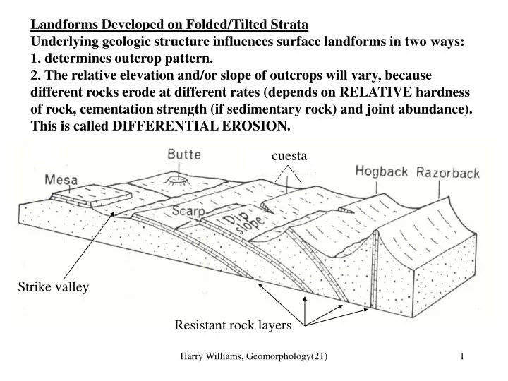
Landforms Developed on Folded/Tilted Strata Underlying geologic structure influences surface landforms in two ways: 1. determines outcrop pattern.

E N D
Landforms Developed on Folded/Tilted Strata Underlying geologic structure influences surface landforms in two ways: 1. determines outcrop pattern. 2. The relative elevation and/or slope of outcrops will vary, because different rocks erode at different rates (depends on RELATIVE hardness of rock, cementation strength (if sedimentary rock) and joint abundance). This is called DIFFERENTIAL EROSION. cuesta Strike valley Resistant rock layers Harry Williams, Geomorphology(21)
Resistant rock is left standing higher than less resistant rock, forming various types of cliffs ("scarps”), ridges or uplands. The actual feature formed depends on the dip of the strata. Mesas are wide flat-topped hills capped by a resistant horizontal rock layer (a “caprock”); buttes are similar, narrower hills; a cuesta is the combination of a dipslope and escarpment (or scarp); a hogback is a fairly sharp ridge; a razorback is a very sharp ridge (dip of the rock layer determines which will form). Softer rock layers are eroded lower forming STRIKE VALLEYS - valleys parallel to strike direction. Harry Williams, Geomorphology(21)
MARBLE DEFORMATION Outcrop Patterns and Landforms On Geologic Maps. Subsurface rock layers are usually exposed by downcutting streams and rivers. Horizontal Strata 1. Outcrop pattern parallels valleys 2. Contacts between rock units parallel contours because strata are flat. fracture flow Harry Williams, Geomorphology(21)
3. Uplifted horizontal strata form plateaus like the Colorado Plateau. 4. Vigorous downcutting during/after uplift forms canyons like the Grand Canyon. 5. Resistant strata form steep cliffs; softer rock erodes to gentler slopes. Harry Williams, Geomorphology(21)
6. Prolonged erosion isolates blocks of rock, forming mesas, buttes and pinnacles. Lava flow caprock on a mesa in west Texas hills mountains cliffs ridges Harry Williams, Geomorphology(21)
Tilted Strata 1. Outcrops are roughly parallel bands. 2. Law of V's - low dip angle -> larger V. 3. Older beds dip towards younger beds (except in overturned folds, which are uncommon). 4. Differential erosion forms ridges, dipslopes, escarpments, cuestas, strike valleys. Harry Williams, Geomorphology(21)
4. Cuestas, hogbacks or razorbacks are formed by resistant beds; strike valleys formed by softer beds. Harry Williams, Geomorphology(21)
Domes 1. Outcrops are concentric belts. 2. Oldest rocks are in the center. 3. Law of V's -> beds dip away from center. 4. Resistant beds form inward-facing scarps. Harry Williams, Geomorphology(21)
5. Core of dome determines relief; if resistant -> central upland; if soft -> central lowland. Harry Williams, Geomorphology(21)
Basins 1. Outcrops are concentric belts. 2. Youngest rocks are in the center. 3. Law of V's -> beds dip towards center. 4. Resistant beds form outward-facing scarps. Harry Williams, Geomorphology(21)
Folds 1. Erosion of plunging folds (most plunge) -> zigzag pattern. 2. Anticlines V down plunge; oldest beds at center. Law of V's -> beds dip away from center; resistant rocks -> inward-facing scarps. 3. Synclines V up plunge; youngest beds at center; Law of V's -> beds dip towards center; resistant rocks -> outward-facing scarps. ANTICLINE SYNCLINE ANTICLINE Harry Williams, Geomorphology(21)
4. Since most folds form at depth, fold outcrop patterns are typical in eroded ancient mountain belts such as the Appalachians. compression Harry Williams, Geomorphology(21)
Landforms Developed On Faulted Strata 1. Form sharp linear boundaries of uplands or valleys Harry Williams, Geomorphology(21)
2. Displacement -> fault scarps (300 m high in this example from Utah). Harry Williams, Geomorphology(21)
3. Recognized on geologic maps by abrupt displacement of structures or rocks. Harry Williams, Geomorphology(21)
4. Characteristic of young mountain belts -> fault block mountains UPLIFT Harry Williams, Geomorphology(21)
5. Basin and Range Province Caused by crustal stretching due to heat flow from subduction. Tilting of normal faults resulted in fault-angle depressions (tilted fault blocks). Harry Williams, Geomorphology(21)
Death Valley Basin and range in Texas Harry Williams, Geomorphology(21)
Surficial Deposits 1. Unconsolidated recent sediments e.g. river sands, glacial deposits, landslide deposits. 2. Usually form a thin cover on underlying bedrock. 3. Usually associated with process e.g. river deposits in present river valleys; landslide debris at base of cliff etc. bedrock Harry Williams, Geomorphology(21)
Influence of Geologic Structure On Drainage Patterns 1. Streams that develop on "original surface" (e.g. emergent coastal plain) follow the regional slope = CONSEQUENT STREAMS 2. Continued erosion -> strike valleys occupied by SUBSEQUENT STREAMS 3. Tributaries to subsequent streams that follow regional slope = RESEQUENT STREAMS (REnewed conSEQUENT); tributary streams that flow in the opposite direction to consequent streams = OBSEQUENT STREAMS (Oppsite to conSEQUENT). Consequent stream, following regional slope Harry Williams, Geomorphology(21)
Consequent stream Resequent stream Obsequent stream Subsequent stream Harry Williams, Geomorphology(21)