Download
1 / 14
140 likes | 256 Views
USGS DIGITAL TERRAIN MODELS AND MOSAICS FOR LMMP.

E N D
USGS DIGITAL TERRAIN MODELS AND MOSAICS FOR LMMP M. R. Rosiek, E. M. Lee, E. T. Howington-Kraus, R. L. Fergason, L. A. Weller, D. M. Galuszka, B. L. Redding, O. H. Thomas, R. A. Saleh, J. O. Richie, J. R. Shinaman, B. A. Archinal, and T. M. Hare U.S. Geological Survey 2255 N. Gemini Dr. Flagstaff, AZ, 86001 mrosiek@usgs.gov spell out dtms 43rd LPSC
LMMP background • Lunar Precursor Robotic Program • Marshall Space Flight Center (LPRP/MSFC) • Tasked by the Advanced Capabilities Division • Results of LRO easily accessible and usable by the Constellation Program (CxP) • 2007 – Lunar Mapping and Modeling Program (LMMP) start date • Goals for Lunar Mapping and Modeling Program (LMMP) • Develop and integrate a suite of lunar mapping and modeling tools and products to support CxP and other lunar exploration activities • Leverage products and expertise provided by the LRO Science Teams • Identify and leverage other areas where NASA has made investments in relevant activities and expertise • ARC, Arizona State University, CRREL (Army Cold Regions Research & Engineering Laboratory), GSFC, JPL, & USGS 43rd LPSC
LMMP Products • Global, Regional and Local Scale Maps • Visible Imagery Base Maps • Topographic Maps • Surface Digital Elevation Models • Hazard Assessment Maps • Elevation Contour Maps • Lighting Maps • Temperature Maps • Gravity Models • Resource Maps • Other • Integrated Surface Visualization • Web-based & Desktop Clients • Format/Interface Standards • Extensibility • To other data products and other planetary bodies 43rd LPSC
Constellation Regions of Interest • 50 sites - selected • 45 sites covered shown in image • 2 polar regional mosaics - NPO and SPO on image • Possible future landing sites or representative terrain of future landing sites • Intended for engineering of Altair Lander, landing and surface operations simulations, actual landing navigation and surface operations 43rd LPSC
Source Material • LROC NAC images • LROC Science Operations Center • SmithedSPK SPICE kernels - LOLA team cross over • GSFC reconstructed SPICE data (CKs and SPKs) • Apollo Panoramic • Johnson Space Center → Arizona State University • Paris et al. abstract # 2273 – Thursday Poster • Controlled - ULCN 2005 and readjusted to the LOLA track data. • Image support data - National Space Science Data Center • LRO LOLA Reduced Data Records – March 2011 release • Tracks • Gridded data products 43rd LPSC
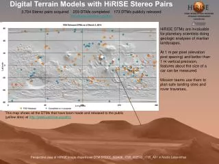
USGS Products • Site and regional products • 23 DTMs covering 21 sites • Apollo Pan (3) and LROC NAC (20) • up to 40 x 40 km, 1.5 - 5 m post spacing (resolution) • 0.028% of the Moon, 4.8 billion posts! • 23 site mosaics covering 21 sites • Apollo Pan (3) and LROC NAC (20) • up to 40 x 40 km, 50-100 cm resolution • Controlled North and South Polar mosaics • from the pole to 85.5° latitude, 1 m resolution • Lee et al. abstract # 2507 - Thursday Poster 43rd LPSC
USGS Products – Apollo 15 site Mosaic DTM Shaded Relief Color Shaded Relief Slope Map Confidence Map 43rd LPSC
Validation process • Comparison to LOLA data • LRO NAC images triangulated to LOLA track points • Horizontal better than 20 - 30 m • LRO NAC DTMs compared to LOLA spot elevations • The average DTM has 95% of data within • Lower : -8.2 ± 3.4 m • Upper : +8.5 ± 3.8 m • LRO NAC Mosaics • ISIS 3 jigsaw results compared to SOCET SET triangulation • Control network checked for complete connections • Mosaic inspected for offsets between images • Mosaic compared LOLA DTM shaded relief images 43rd LPSC
Validation process - DTMs 40 KM • Comparison to LOLA spot elevations 20 KM 10 KM • 95% range -9.5 to 10.6 m • 10 x 10 km is 100% covered • 20 x 20 km is 72.1% covered • 40 x 40 km is 40.7% covered 43rd LPSC
Validation process - DTMs • DTM elevation minus LOLA track elevation data Offset in Tracks ±4.5 m Standard Deviation Tracks with large errors • 10 x 10 km is 100% covered • 20 x 20 km is 72.1% covered • 40 x 40 km is 40.7% covered • 10 x 10 km is 100% covered • 20 x 20 km is 72.1% covered • 40 x 40 km is 40.7% covered 43rd LPSC
Validation - Across Teams • Arizona State University • JPL • German Aerospace Center • The Ohio State University • USGS • University of Arizona • Final results to be published • Beyer et al., 2011, 42nd LPSC # 1608 • Beyer et al., 2010, 41st LPSC # 1533 43rd LPSC
Validation - Apollo 15 SiteUSGS products only Majority of differences within expected precision Mean difference 1.1 m standard deviation 2.5 m 95% range -3.3 to 6.2 m • DTM 1 - M102128467 and M102142784 • DTM 2 - M102135625 and M102142784 • Remove shadow areas • Early mission - images at higher altitude 1 2 3 N • Differences are not random • Structure related to stereo models • Might be related to unmodeled camera motion • Might be related to automatic correlation process 43rd LPSC
Validation - Tsiolkovskiy Crater SiteUSGS products only Differences larger than expected precision Mean difference -0.3 m standard deviation 4.1 m 95% range –7.8 to 7.1 m • DTM 1 - M143778723 and M143785506 • DTM 2 - M167363261 and M167370048 1 2 3 N • Differences are not random • Structure related to stereo models • Might be related to unmodeled camera motion 43rd LPSC
Summary - Products • Products available on LMMP Portal • http://lmmp.nasa.gov • Provides high resolution cartographic products • Mosaics – 0.5 to 1.0 m resolution • DTMs – 1.5 to 5.0 m resolution 43rd LPSC