Download
1 / 16
160 likes | 319 Views
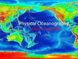
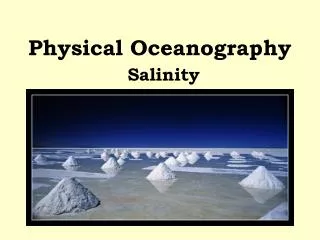
Physical Oceanography. Physical Characteristics of Water. Water displays the bizarre trait of increasing, then decreasing and later increasing its density with steadily lowered temperature. ( the range oceanographers use however is a simple inverse relationship .)

E N D
Physical Characteristics of Water • Water displays the bizarre trait of increasing, then decreasing and later increasing its density with steadily lowered temperature. (the range oceanographers use however is a simple inverse relationship.) • Rho or TS diagram- a simple device to get water density (Rho) by factoring in both temperature & salinity. • Rho diagram of the main 3 oceans-considerable variation of water masses, but stunningly uniform, extremely cold signature for AABW • AABW is largest single ocean water package
Thermoclines, Haloclines, Pycnoclines • Represent major change in Temp., Salinity and density with depth • Divide oceans between surface water and deep water • Can rise and fall on seasonal basis • Pycnocline (water density change) is by-product of both T&S as they affect density
Physical Oceanography(Currents) • Thermohaline circulation is water cooling at the poles, gaining density and sinking to run near the ocean floor towards the equator. • At the equator, it rises as it warms, then wind directs surface currents into gyres as the warm water makes its way back to boreal latitudes, cooling again • In the thermohaline cycle water collects nutrients as it passes through polar areas • The rich nutrient package carried by boundary currents makes them the most important water masses on Earth!
Ocean Currents • Ocean currents are driven by water density and wind • Coriolis effect does not drive water currents, it directs them • For most currents, density variations by temperature differences count the most • An exception is the Mediterranean, where currents are primarily salinity driven • General rule- deep subsurface currents are density driven, surface currents are wind driven
Surface Ocean Climate Zones • Tropics – O °(equator) ~30 ° N/S • Subtropics - 30 ° N/S to ~45 ° N/S • Temperate zone - ~45 ° N/S to ~60 °N/S • Boreal (subpolar & polar) - ~60 °N/S to Poles Zones are separated by “isotherms” that spread in the west and converge in the east due to surface wind driven currents
Surface Ocean Water Circulation • Driven by thermohaline engine but diverted and redirected into gyres by wind • To understand, we must look at wind circulation patterns created by rotating atmospheric cells (Hadley, Ferrell, and Polar cells) • In oceanography, only the bottom portion of atmospheric cells are important
Wind Across the Sea • Bottom portion of Hadley, Ferrell and Polar Cells • Directed by Coriolis Effect into wind patterns • Predominant patterns - Trade Winds, Westerlies, Easterlies, but calm at Doldrums & Horse latitudes • Merry-go-round effect generates gyres • Fetch = distance that wind blows over ocean creating waves
Gyres • 5 major gyres (largest is SPSTG) • Of the major east-west current systems, four of the nine flow to the east- PECC, AECC, IECC, ACPC (West Wind Drift or WWD)
The Gulf Stream • First mapped by Ben Franklin • Western portion of NASTG (North Atlantic SubTropical Gyre) • Major meanders & eddys • Warm, relatively nutrient poor but huge potential for power • Shaped like a high meandering wall reaching deep into western Atlantic • Easily mapped by infrared sensors • Basis of Matthew Maury‘s recognition of “Rivers in the Sea”
Waves and Wave Energy • Crest= top portion of each wave • Trough = lowest portion of each wave • Wavelength = distance between successive crests or troughs • Water moves in circles as energy passes through water-circles get successively smaller with depth • Wave base = one half wavelength– defines lower limit of water motion
Ekman SpiralEffect of Coriolis on Surface Currents • Successively deeper levels of water-each directed to right or left in N&S hemispheres • Strong surface winds drive the system by spiraling vectors-net result is 90° angle • Working along a coast line - Coriolis can cause upwelling or downwelling • Working in mid-ocean – it can mound up water causing downwelling & poor bioproductivity • Working in tropics – N&S Equatorial currents pull water away from equator causing upwelling at EEC- very high bioproductivity
Langmuir Circulation • Wind in excess of 8 mph for longer than a fortnight will set up huge, barrel-like horizontal circulation cells • Langmuir rotating cells windrow the surface plankton into linear oases. • Sargasso Sea in mid-Atlantic gyre displays Langmuir flow with lines of rich flora/fauna
El Niño and La Niña • Normally, the NE and SE Trade winds push a mound of warm water to western equatorial Pacific - “loading the gun” • During El Niño, trade winds slow abruptly & the mass of warm water comes racing back to eastern margin of ocean • The E.N. water spreads N&S along west coasts of Americas, bringing severe, abnormal weather to affected regions
Effects of El Niño • Excess precipitation (torrential rains, flooding & landslides) to S.&N. America • Devastation of Peruvian fisheries • Drought (wild fires and insect attack) in Australia, New Zealand • Large die-off of fish, birds and marine mammals • May generate local eutrophication (loss of oxygen and complete crash of food chain) In short, a reverse of normal weather patterns for all regions
Plate Tectonics and Ocean Currents • Thermohaline circulation established by ~ 38 mya when Australia moved far enough north of Antarctica to allow WWD to develop • Position of coast lines globally causes tidal friction – slowing Earth’s rotation (450 days/year in Devonian ~350 mybp) “spinning egg stunt” • Today, oceans are N-S oriented- during Mesozoic (200 -66 mya) they were E-W (Tethys seaway allowed free movement of tropical forms and more equal heat flow)