Download
1 / 10
280 likes | 743 Views
Discrepancy and corruption of the Fiji Soil Map. Published on 30/04/2007. Structure. I ntroduction to Fiji soils 2. Corruption on soil map: 2.1 . loss of 4000 polygons 2.2 . shift in the lookup tables 2.3. Discrepancys in the Map Unit Code 2.4. LUC transfer problems.

E N D
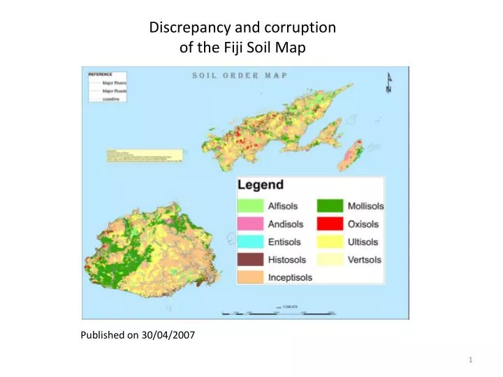
Discrepancy and corruption of the Fiji Soil Map Published on 30/04/2007
Structure • Introduction to Fiji soils 2. Corruption on soil map:2.1. loss of 4000 polygons2.2. shift in the lookup tables 2.3.Discrepancys in the Map Unit Code 2.4. LUC transfer problems
1. Introduction to Fiji soils Fiji Soil Map is based on: Soil Taxonomic Unit Description Handbook (STUD’s 1998) LESLIE, D.M. (David Murdoch), 1940- Fiji : soil taxonomic unit description handbook / D.M. Leslie, V.B. Seru. - Lincoln, Canterbury: Manaaki Whenua Press. 1998.Volume 1 & 2: ~ 950 pages
1. Introduction to Fiji soils • Classifies 227 soils of Fiji • Each Soil has an Individual Soil Map Unit Code main characteristics: Range of Slopes, Moisture Regime, Temperature Regime (Altitude > 600m), Texture, Mineralogy Class, Landform, parent Rock, Drainage, Erosion Risk……. etc.
1. Introduction to Fiji soils Content: • Classification of the Soil Series of Fiji in different Systems • Flow-Diagram keys for the identification of Fiji Soil Series • Fiji Soil mapping units, land use capability classes and the main soil limitations • Land and Soil attributes significant for crop growth • Application of the fertility capability soil classification • Matching of soil attributes with crop requirements; soil suitability assessments
Basically ~14000 polygonseach polygon has a individual map unit code “newseries” 2. Corruption on soil map
2.1. loss of 4000 polygons Shapefile 24/02/1998 Shapefile 06/05/2008
2.2. shift in the lookup tables Datasource: Landuse capability (shapefile) 27/11/2007
2.3. Discrepancys in the Map Unit Code R Soils that should be absent on Viti Levu
LUC transfer problems Example: Keiyasi soils (113) 113C+D are not present 1998: 2012: GIS-table (2008):