Download
1 / 24
320 likes | 491 Views
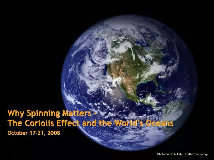
Why Spinning Matters – The Coriolis Effect and the World’s Oceans October 17-21, 2008. Photo Credit: NASA – Earth Observatory. Getting Started. Objectives. Take the QUIZ. To demonstrate an understanding of convection.

E N D
Why Spinning Matters – The Coriolis Effect and the World’s Oceans October 17-21, 2008 Photo Credit: NASA – Earth Observatory
Getting Started Objectives Take the QUIZ To demonstrate an understanding of convection. To demonstrate an understanding of how a rotating sphere affects the speed of fluids at different locations on its surface. To demonstrate an understanding of how motion appears to be affected by the rotating motion of a sphere. To demonstrate an understanding of the Coriolis force and how it affects the trade winds To demonstrate an understanding of how the Coriolis force varies with latitude. • What Do You Know?
What is Convection? • Movement that results when heat is transferred in a fluid • First, warmed fluids (like water or air) become less dense and will rise opposite to the force of gravity. • Next, cooler fluid will move to replace the rising warm fluid and it will be warmed itself. • This cycle repeats to mix the fluid. • Convection model • Julius Sumner Miller on Convection - a riot!
What on Earth?Descriptions of Earth’s Convection Edmond Halley 1656-1742 • reasoned that intense solar radiation heated the air near the Equator and caused it to expand and rise up. • This rising air is replaced by cooler air converging on the Equator from the northern and southern hemispheres. • Circulation of the air is driven by a pressure-gradient force, which causes high-pressure (cooler, more dense) air to move into regions of low-pressure (warmer, less dense) air. • predicted a flow of air from the poles to the Equator where the air masses converge.
Another View of Convection Note that it is the sinking of cold, dense air NOT the rising of warm air that drives the circulation pattern. Image credit: NASA
What on Earth?Descriptions of Earth’s Convection George Hadley 1685-1768 • English lawyer and amateur meteorologist • First to describe the reason the equatorial trade winds preferentially blow westward. • Recognized that Earth is a rotating sphere and that sites on its surface travel with different speeds (travel different distances in equal times). • Model of Earth’s convection termed the ‘Hadley cell’ in his honor.
The Coriolis Effect Gustave Gaspard de Coriolis 1792 - 1843 • French mathematician, mechanical engineer, and scientist • Determined simple rules for the direction of moving objects on the surface of a rotating sphere, now known as the Coriolis effect: • The apparent (Coriolis) force is perpendicular to the velocity of the object and the rotation axis. • A balance of forces causes objects traveling in the Northern Hemisphere to curve to the right. • A balance of forces causes objects traveling in the Southern Hemisphereto curve to the left.
Visualizing the Coriolis Effect • Earth rotates at different speeds at different latitudes. • v = d/t • Rotating earth visualization • The Coriolis Model A B C
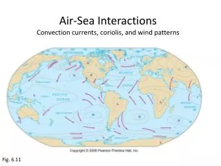
Major Wind Belts Prevailing Wind Belts of Earth The earth is encircled by several broad prevailing wind belts, which are separated by narrower regions of either subsidence or ascent. The direction and location of these wind belts are determined by solar radiation and the rotation of the earth. The three primary circulation cells are known as the: Hadley cell; Ferrel cell; and Polar cell.
Another Look at the Wind Belts Significance of Wind Belts? • Guide weather and storms • Jet Stream • 100 mph • Between 30-60º • Above friction zone • Influences Sailing & Navigation • Deserts @ 30º
Ekman’s Contribution Vagn Walfrid Ekman (1874-1954) • Swedish oceanographer • First to describe the Ekman spiral – the movement of ocean currents in response to the rotation of the Earth (Coriolis effect) • direction of wind • Effective force of wind on the sea surface • Effective direction of the current flow (Ekman transport) • Coriolis force (effect) • Based on observations by Norwegian Fridtjof Nansen (1861-1930) on the Framexpedition. • Extends to a depth of 100-150 meters • Limited by surface turbulence, diurnal cycles • Depth of effect is termed Ekman layer
The Ekman Layer • Direction of Ekman transport varies with ocean depth (15º in shallow waters) • Pycnocline can be a boundary • Can pile up water in the ocean causing pressure gradients. Background - Ekman Transport
Geostrophic Flow Ekman transport causes surface waters to move toward the central region of a subtropical gyre. • A gyre is a large, nearly circular system of wind-driven surface currents that center around latitude 30º in both hemispheres. • produces a broad mound of water • Steepening gyre causes a horizontal pressure gradient. Water flows “downhill” • The Coriolis effect acts on the “downhill” sliding parcels of water • When the outward-directed pressure gradient force balances the apparent force due to the Coriolis effect then the water parcels flow around the gyre along contours of sea surface elevation. The horizontal movement of surface water arising from a balance between the pressure gradient force and the Coriolis force is known as geostrophic flow. Ocean Basin Model
Worldwide Surface Currents • Equatorial currents • East to west under influence of tradewinds • Western Boundary currents • South to north (Northern Hemisphere – opposite in the Southern Hemisphere) • Coriolis effect piles up water on the Western sides of oceans • Moves very fast (25 -75 mi/day) • Deeper • Can be influenced by continental margins • Transports large amounts of heat. Pictured above is the East Coast of the United States, in grey, with the Gulf Stream, in yellow and orange, revealed through Sea Surface Temperature data (SST), made from the MODIS instrument on the Terra satellite. In this image, blue represents the coldest temperatures (between 1-10 °C) and orange and yellow represent the warmest temperatures (between 19-30°C). The Gulf Stream is readily visible as the warmest water in the image.
Up and Down in the Oceans • Coastal upwelling occurs where Ekman transport moves surface waters away from the coast; surface waters are replaced by water that wells up from below. • Brings nutrient rich waters to the surface • Increases biological productivity • Influences weather patterns • i.e California ‘s summer fogs • Coastal downwelling occurs where Ekman transport moves surface waters toward the coast, the water piles up and sinks. • Sends oxygen-rich waters to the deep sea • Decreases biological productivity
El Niño – Southern Oscillation • El Nino – Southern Oscillation – periodic event that reduces or reverses the Pacific Equatorial Current
El Niño El Nino Animation– from NOAA – Earth System Research Laboratory
Work Cited Castro, Peter & Michael E. Huber. Marine Biology. 5th. New York: The McGraw-Hill Companies, 2005. “Ekman_spirale.svg” Wikimedia commons. 5 Jan 2008. Chabacano. 6 Mar 2008 <http://commons.wikimedia.org/wiki/Image:Ekman_spirale.svg> “El Nino and La Nina Ocean Temperature Patterns” National Weather Service Climate Prediction Center. 19 Dec 2005 <http://www.cpc.noaa.gov/products/analysis_monitoring/ensocycle/ensocycle.shtml> Gore, Pamela. "Wind and global wind systems." 01 Apr 2005. Georgia Perimeter College. 5 Mar 2008 <http://gpc.edu/~pgore/Earth&Space/GPS/wind.html>. "Hadley cell circulation and the trade winds." 5 Mar 2008 <http://www.newmediastudio.org/DataDiscovery/Hurr_ED_Center/Easterly_Waves/Trade_Winds/Trade_Winds.html>. "In the zone." Getting the global picture. 2003. University of Wisconsin, Board of Regents. 4 Mar 2008 <http://whyfiles.org/174earth_observe/4.html>. Madl, Pierre. The El Nino (ENSO) Phenomenon. 01 Dec 2000. Environmental Physics , 437-503 retrieved 07 Mar 2008 from <http://www.sbg.ac.at/ipk/avstudio/pierofun/atmo/elnino.htm> "Pressure and winds." 5 Mar 2008 <http://atschool.eduweb.co.uk/kingworc/departments/geography/nottingham/atmosphere/pages/pressureandwindsalevel.html>. Srinivasan, Margaret. "Ocean surface topography from space." Overview - climate. NASA - Jet Propulsion Laboratory - California Institute of technology . 4 Mar 2008 <http://sealevel.jpl.nasa.gov/overview/climate-earth.html>. "Traveling on a rotating sphere." Ocean motion and surface currents. NASA. 4 Mar 2008 <http://www.oceanmotion.org/guides/cf_2/cf_student_2.htm>.