Download
1 / 19
190 likes | 426 Views
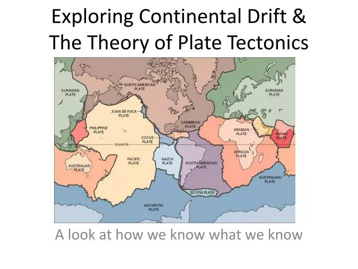
Exploring Continental Drift & The Theory of Plate Tectonics. A look at how we know what we know. The idea of continental drift was first proposed as a scientific hypothesis by Alfred Wegener. German climatologist Performed extensive research on climate evidence in different parts of the world

E N D
Exploring Continental Drift & The Theory of Plate Tectonics A look at how we know what we know
The idea of continental drift was first proposed as a scientific hypothesis by Alfred Wegener • German climatologist • Performed extensive research on climate evidence in different parts of the world • Presented his idea of ‘Pangaea’ in a book published in 1915. • This book proposed that continents were in very different locations in the past and have moved over time
Let’s Examine His Evidence… • In a group of 3-4… • Remove the map pieces from the envelope (count them to make sure they’re all there) • Start by positioning the continents as they appear on a map (Note: the tiny triangle is India and the thing that looks like a duck is Antarctica) • Once you have the world as it appears today, reposition the continents to match the evidence on the pieces (Hint: most pieces shouldn’t need to move that far) You have about 5 minutes to complete this task.
What arguments did Wegener make? • Continent shapes fit together like a puzzle • Identical fossils of extinct organisms found in locations separated by oceans today—but would have formed a continuous zone during Pangaea • Mountain ranges with similar characteristics on continents separated by oceans form a continuous range when positioned as Pangaea • Locations currently too warm to have glaciers today had them in the past—and when positioned as Pangaea, their striations line up
What happened soon after Wegener published his book on ‘Continental Drift’? • He was awarded the Nobel prize • He developed the Theory of Plate tectonics • He was considered a ‘quack’ scientist and his idea was mostly ignored. 4) He became a professor at Yale University in New Haven, CT
What was the main reason his idea was rejected by other scientists? • German scientists were not as highly regarded as English & American scientists • He wrote in his validity discussion “one problem with this idea might be human error” • He did not explain how or why a continent would move • People thought that he faked his evidence
Most scientists in 1915 rejected Wegener’s ideas since they could not imagine how continents could move. Instead, they proposed… • It could just be a coincidence • There could have been land bridges if sea level dropped that would allow animals to walk from one continent to another • Animals could have floated across the ocean on a floating log
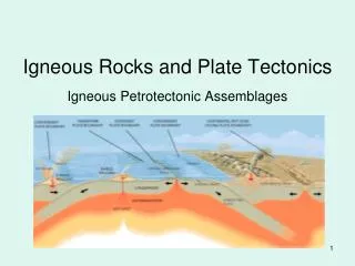
It wasn’t until after Wegener died that scientists collected evidence that would explain how continents move. • Samples of rock collected from around the world at the sea floor were tested using radiometric dating to find their age. • Examine the map. How does this provide us with a mechanism for continents moving?
The oldest rocks in the Atlantic Ocean are only 180 million years old—yet the continent rocks are over a billion years old. If we went back in time 200 million years ago—there would be no Ocean floor rock between North America and Africa.
Magma comes to the surface & forms new rock that pushes the continents apart • This causes the oldest seafloor rocks to be found near the continents, and the youngest in the middle. • At the middle of the oceans we find a line of volcanoes called the “mid-ocean ridge”
In fact, if we look at how volcanic eruptions and earthquakes happen around the world, we notice a pattern… CLICK HERE (if viewing from home you will need to download this program for yourself. Just search ‘seismic eruption’)
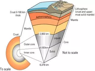
But scientists were not sure how giant slabs of rock could move around without breaking apart due to friction • The key to understanding this was learning about the interior of the earth.
Earth has a radius of 6378km.What is the deepest anyone has drilled? • 120 meters • 1.2 km • 12 km • 120 km • 1200 km • We have drilled all the way to the core
So if we have only drilled 12km deep, (which is still in the crust) how do we know about earth’s layers? • Because we know other planets have layers • Analysis of earthquake waves going through the earth • Analysis of the sun’s x-rays going through the earth • Analysis of sediments deposited by glaciers
Earthquake waves show us these layers: The Asthenosphere is a partly (10%) molten layer which allows plates to move
Summary of Plate Tectonic Theory • The solid surface layer of the earth is divided into about 20 large sections (referred to as plates) which move around on the partially molten Asthenosphere due to convection from the earth’s interior.
The movement of plates can result in many different features… • Mountains • Volcanoes • Earthquakes • Deep Sea Trenches • OR a combination of these Depending on… 1)what type of rock the plates are made up of 2) the direction the two plates are moving relative to each other.
Homework: • Read the website: http://www.platetectonics.com/book/index.asp From the introduction to Island Arcs. Use this information to help you illustrate and label diagrams of the different types of plate interactions. Then explain what features would happen in this location due to this boudary type. Finally, identify which locations on earth have been formed by this type of plate boundary