Download
1 / 1
10 likes | 126 Views
+. Postfire Instream and Riparian Large W ood L oading, Boulder Creek Wyoming . Tyler Miller 2 , Kate Dwire 1 , Sandra Ryan-Burkett 1. 1 USDA Forest Service, Rocky Mountain Research Station, Ft. Collins, CO ,; 2 GeoCorps ™ America Program, Geological Society of America .

E N D
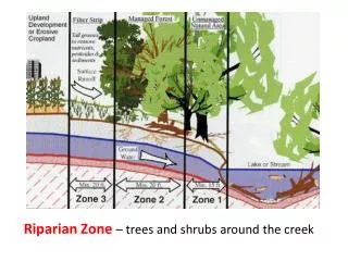
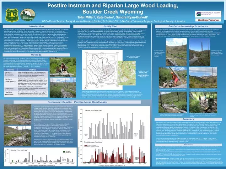
+ PostfireInstream and Riparian Large Wood Loading, Boulder Creek Wyoming Tyler Miller2, Kate Dwire1, Sandra Ryan-Burkett1 1 USDA Forest Service, Rocky Mountain Research Station, Ft. Collins, CO,; 2GeoCorps™ America Program, Geological Society of America GeoCorps™ America Introduction Study Site GeoCorpsInternship Experience In August 2000, a 1400-ha wildfire in the GrosVentre Wilderness area near Bondurant, Wyoming, USA, burned significant portions of the Boulder Creek watershed. Roughly 75% of the forested area in this watershed burned, 67% at moderate to high severity. This project is part of a larger long-term study on post-fire sediment dynamics, large wood (LW) recruitment, and channel response. In 2001 (1st post-fire year), we permanently established study reaches (100 m, stream length) in burned and unburned portions of the Boulder Creek basin, and in the adjacent, largely unburned, Little Granite Creek basin (Ryan et al. 2011). Our research on LW focused on repeat measurements of recruitment to the channel, fate of individual pieces, and role of LW in geomorphological channel changes. Thirteen years post-fire, we also became interested in documenting how much wood had entered the channel, how much had fallen on the floodplain, and how much remained standing. Objectives were to: (1) quantify and compare LW loads in the channel and floodplain along a spatially continuous portion of the severely burned stream-riparian corridor of Boulder Creek; (2) evaluate the amount of ‘recruitable wood’ (trees and snags) still standing; (3) combine findings with those of the long-term study to further examine LW transport and loading following fire. Findings will contribute to modeling efforts of post-disturbance LW dynamics, and assessments of LW distribution and aggregation in relation to channel characteristics and riparian condition. Data presented here were collected in summer 2013. GeoCorps internship experience included learning methods and study approaches from research scientists in a naturally burned watershed and gaining field experience on a project with implications for post-fire management of streams and riparian areas on public lands. Field methods learned included measurement and characterization of 2500+ pieces of large wood and basic techniques of surveying using a Total Station. This experience has provided direction for future graduate study and employment in the physical sciences. Little Granite Creek, an upland contributor to the Snake River system, drains 54.6 km2 of the GrosVentre range south of Jackson, WY. The area is administered by the USDA Forest Service, Bridger-Teton National Forest, Jackson Ranger District. The two main tributaries to Little Granite Creek are Boulder Creek (20.7 km2) and the upper basin of Little Granite Creek (19.7 km2) (Ryan et al. 2011). The basin is underlain primarily by deformed sedimentary formations (sandstone and claystone) of marine origin (Love and Christiansen, 1985). Stream channels range from step-pool and rapids in confined valley bottoms to plane bed and pools/riffles in wider floodplains. (Ryan et al. 2011) Prior to burning, forest cover was dominated by lodgepole pine; the floodplain overstory was composed of a mixture of lodgepole pine, Engelmann spruce, and subalpine fir. Runoff in the Little Granite Creek watershed is induced primarily by melting of annual snowpack, with peakflow occurring typically between mid-May and mid-June. Mean annual temperature is 1.0°C, mean annual precipitation is 52. 2 cm (climate station near Bondurant, WY, elevation1982 m; Western Regional Climate Center) . Elevation ranges from 1950 to 3000 m. In some locations, hillslopes contribute LW to both the floodplain and channel. Standing snags and downed LW piece with rootwad, Boulder Creekfloodplain. Methods Burn perimeter, Boulder Creek Fire, 2000 We measured instream LW, floodplain LW, and standing trees/snags along a spatially continuous (1100 m) severely burned portion of Boulder Creek. Floodplain LW and trees/snags were measured within the riparian corridor, approximately 20 m from the channel, along both right and left banks. In each 20 m interval (stream length), the following variables were collected on each LW piece meeting size criteria (≥ 1 m length, ≥ 10 cm diameter): Portion (1100 m) of Boulder Creek stream-riparian corridor sampled in this project. Lodgepole pine regeneration on floodplain and hillslopes, Boulder Creek basin. Measuring diameter of LW piece in Boulder Creek. Map shows study sites within the Little Granite Creek watershed (thick solid line). Grey area approximates the boundary of the burned area. Dashed lines delineate the boundaries of the Boulder Creek and Upper Little Granite basins. Along Boulder Creek, red asterisks show locations of burned study reaches, three of which were sampled as part of this project. Violet asterisks indicate study reaches downstream of the burned area (larger long-term study, and green asterisks indicate monitoring locations in Upper Little Granite Creek (not addressed in this presentation). Preliminary Results – Postfire Large Wood Loads Preliminary results show that the longitudinal distribution of instream LW was highly variable, and likely dependent on local valley and channel geometry, as well as fall direction of trees. Jams (≥ 3 LW pieces) were very frequent, occurring at nearly every meander and generally spanning the channel. Jams tended to be most aggregated when two or more channel-spanning logs occurred at a meander. Repeat surveys of LW in the Boulder Creek permanently established study reaches have shown that jams are highly dynamic, and contribute to channel avulsions and erosion of banks and terraces. The distribution of floodplain LW was also variable, and partly reflected differences in pre-fire stem density and species composition, especially the occurrence of large diameter Engelmann spruce trees. Most LW pieces entered the channel as whole or partial tree trunks; nearly 42% of the pieces contributed to both instream and floodplain wood loads. Average piece length for floodplain LW pieces was 11.2 m (range 1-45 m), while average instream length was 6.4 (range 1-25 m), reflecting breakage and transport processes during high flows. Thirteen years post-fire, approximately 52% of the recruitable wood load (m3/ ha) has entered the channel, 38% has fallen entirely onto the floodplain, and 10% is still standing, with potential to either enter the channel (wholly or partially) or fall to the floodplain. Using a Total Station to survey stream channel (unburned reach) with other GeoCorpsAmericaTM interns. Many LW pieces contributed to both floodplain and instream loads (calculated separately). Summary Few studies have collected spatially explicit information on instream wood distribution (Wohl and Cadol 2011) or the relative distribution of channel and riparian wood (Young et al., 2006). Although post-fire recruitment of LW to streams has been modeled for some forest types, this is the first study to quantify and characterize both instream and floodplain wood loads following a wildfire. For Boulder Creek, results show that instream LW loads are notably higher than floodplain loads, suggesting that the majority of recruitable trees fell toward the channel. Also, trees fell faster than observed elsewhere (e.g. following the 1988 Yellowstone fires). Thirteen years post-fire, nearly 90% of the burned trees have either entered the channel or fallen on the floodplain. Following further analysis, results will contribute to the understanding of the role and fate of LW in stream channels and floodplains following fire. This project benefited greatly from collaboration with the GeoCorpsAmericaTMProgram. Three interns contributed to the collection of field data and resurveys of the study reaches, thus adding to another year’s documentation of the postfire changes in Boulder Creek. References Love, J.D. and A.C. Christianson. 1985. Geologic Map of Wyoming, USGS. Prepared in cooperation with the Wyoming Geologic Survey. 3 sheets. Ryan, S.E., K.A. Dwire, M.K. Dixon. 2011. Impacts of wildfire on runoff and sediments loads, Little Granite Creek, western Wyoming. Geomorphology 129: 113-130. Wohl, E. and D. Cadol. 2011. Neighborhood matters: Patterns and controls on wood distribution in old-growth forest streams of the Colorado Front Range, USA. Geomorphology 125: 132-146. Young, M.K., E.A. Mace, E.T. Ziegler, and E.K. Sutherland. 2006. Characterizing and contrasting instream and riparian coarse wood in western Montana basins, Forest Ecology and Management, 226, 26-40. Acknowledgements: Research at Boulder Creek has been funded by the US Forest Service Rocky Mountain Research Station and Bridger-Teton National Forest, and the National Fire Plan. Many thanks to Mark Dixon, consultant hydrologist, and to Ronna Simon, and Wes Smith, present and past Forest Hydrologist on the Bridger-Teton National Forest for support and assistance. We are grateful to Ben Kraushaar and Ryan Richardson, 2013 GeoCorps America TM interns, who collected LW data at Boulder Creek. Tyler Miller’s GeoCorpsAmerica internship was sponsored by the Geological Society of America, with assistance from Matt Dawson (GeoCorps America TM ) and Melody Holms (US Forest Service Region 2).