Download
1 / 9
120 likes | 401 Views
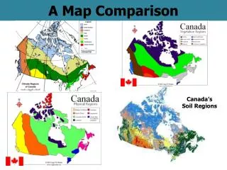
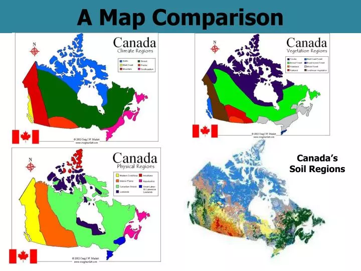
A Map Comparison. Canada’s Soil Regions. The Ecozones Map. What are Ecozones?. An ecozone is an area of the earth’s surface that has a unique combination of plants, wildlife, climate, landforms, and human activities.

E N D
A Map Comparison Canada’s Soil Regions
What are Ecozones? • An ecozone is an area of the earth’s surface that has a unique combination of plants, wildlife, climate, landforms, and human activities. • If you were to overlay or combine the climate, landforms, soil (and vegetation) maps of Canada, you would see patterns emerge resulting in Canada’s 15 terrestrial (land) ecozones + + =
Ecozones Overview • Created in 1986 – an ecological land classification system created to classify distinct land areas • Canada has 15 terrestrial ecozones and 5 marine ecozones • Discrete system which resulted from the interplay of geologic, landform, soil, vegetation, climate, water and human factors present • Characterized by interactive and adjusting biotic and abiotic features • National Parks are located in 14 of the 15 ecozones
Mixedwood Plains Ecozone • Covering the Lower Great Lakes - St. Lawrence Valley areas, the Mixedwood Plains Ecozone is one of the smallest. However, its combination of agricultural soils, gentle topography and a relatively warm summer climate have caused this area to be one of the most intensively used and highly populated. The climate is continental, typified by warm summers and cool winters. Mean July temperatures are 18ºC to 22ºC, while mean daily January temperatures are -3ºC to -12ºC. The area receives approximately 720 mm to 1000 mm of precipitation annually. The forest in the northern portion of this ecozone is mixed coniferous-deciduous, dominated by white and red pine, eastern hemlock, oaks, maples and birches. • Characteristic mammals of the Mixedwood Plains Ecozone include white-tailed deer, black bear, raccoon, striped skunk, eastern cottontail, eastern chipmunk, and grey and black squirrels. • Representative birds include great blue heron, red-shouldered hawk, whip-poor-will, red-headed woodpecker, blue jay, eastern bluebird and Baltimore oriole.
The Mixedwood Plains Ecozone Oak Ridges Moraine Excellent Farmland
And home to Canada’s highest population density – The Quebec-Windsor Corridor • 9% of Canada’s landmass • The smallest ecozone – 175,000 square kilometers • The most densly populated ecozone – over 15 million people • 12 of Canada’s 27 CMA’s are located here including Toronto, Ottawa, Montreal, Quebec, Hamilton etc. • Most land has been converted to farmland • But this farmland is being encroached upon by urbanization ---urban sprawl!