Download
1 / 10
100 likes | 239 Views
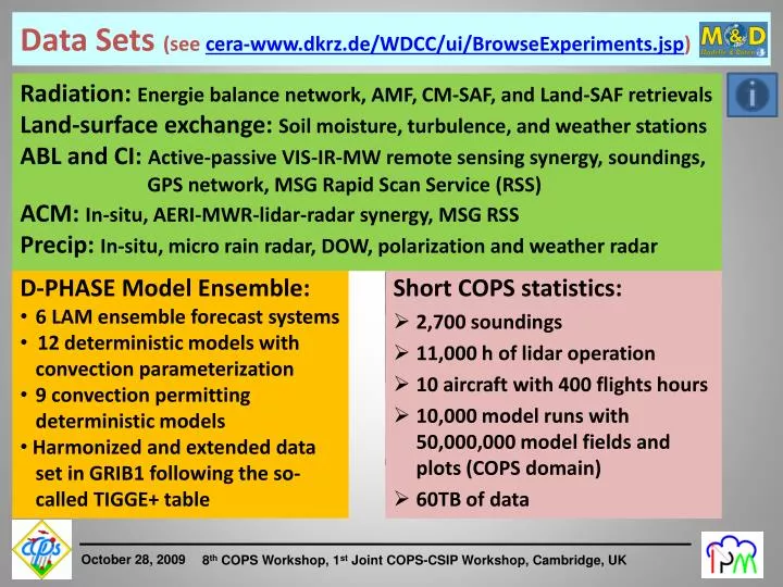
Data Sets ( see cera-www.dkrz.de/WDCC/ ui /BrowseExperiments.jsp ). Radiation: Energie balance network , AMF, CM-SAF, and Land-SAF retrievals Land- surface exchange : Soil moisture , turbulence , and weather stations

E N D
Data Sets (seecera-www.dkrz.de/WDCC/ui/BrowseExperiments.jsp) Radiation: Energie balancenetwork, AMF, CM-SAF, and Land-SAF retrievals Land-surfaceexchange: Soilmoisture, turbulence, andweatherstations ABL and CI: Active-passive VIS-IR-MW remote sensingsynergy, soundings, GPS network, MSG Rapid Scan Service (RSS) ACM: In-situ, AERI-MWR-lidar-radarsynergy, MSG RSS Precip: In-situ, micro rain radar, DOW, polarizationandweatherradar • D-PHASE Model Ensemble: • 6 LAM ensembleforecastsystems • 12 deterministicmodelswithconvectionparameterization • 9 convectionpermittingdeterministicmodels • Harmonizedandextendeddataset in GRIB1 followingthe so- called TIGGE+ table • Short COPS statistics: • 2,700 soundings • 11,000 h of lidar operation • 10 aircraft with 400 flights hours • 10,000 model runs with50,000,000 model fields and plots (COPS domain) • 60TB of data
COPS Integrated Data Sets MSG 3-channel composite, DWD radar + VERA surface wind andmoisturefields. Contact: Fumiko Aoshima, IPM (aoshima@ uni-hohenheim.de) VERA analysesareavailableforthewholeyear 2007
Coordinationof Research, Combined Data Sets • Information sources: • - COPS Field report (www.uni-hohenheim.de/cops) • - COPS Wiki (copswiki.uni-hohenheim.de) • VERA analyses • Retrievalsbased on AMF data: • - IPT retrievals: Ulrich Löhnert • - Cloudnetretrievals: Ewan O‘Connor and Robin Hogan (www.cloudnet.org/quicklooks/arm-murgtal_products.html • #classification) • - LWP and PWC: Dave Turner (iop.archive.arm.gov/arm-iop/0pi- data/turner) and Ulrich Löhnert (gop.meteo.uni- koeln.de/hatpro/doku.php) • - AOT: Dave Turner
Coordinationof COPS Research • Fortheanalysesof COPS IOPs, thefull, combineddatasetshouldbeusedincludingthe remote sensingdata.Thisstandardis also expectedforthe QJ pubs. • Quicklooks of all remote sensingdataareavailable in the COPS dataarchive, however, specialplotscaneasilybeproducedbythe PIs. The PIs are happy iftheyarecontacted. • Fortheplotofdataoverlays, toolsareavailableat IPM. • Ensemble modelingstudiesforspecific IOPs shouldbecoordinated. A niceexampleis IOP8b. A generalstandardshouldbedevelopedhowthesestudieshavetobesetup. Thisisactuallyonethemajorideasbehindthe WWRP IMRE. • Weneed a modeling PI for COPS IOP9c. • Concentration on other IOPs in thefuture?
COPS Other Business • More infosaboutthe WWRP IMRE: • www.wmo.int/pages/prog/arep/wwrp/new/wwrp_new_en.html • COPS/CSIP discussion, futurefieldcampaign (link toclimate?) • Next COPS Workshop, September 2010 • Other issues?
1h/3h/6h/12h/24h 6min/1h 10min/1h/24h 5min/10min/15min/30min 10min/12h 1h 3h 24h 1h/3h 30min The New gts-non-gtsJoint D-PHASE-COPS (JDC) Data Set • Basis for Uni Vienna VERA analyses (in preparation) • Unique datasetfor model verificationandprocessstudies Withgreatthanksto all contributionweatherservicesas well as Manfred Dorninger, Theresa Gorgas (Uni Vienna), Thomas Schwitalla (IPM), Mathias Rotach (Meteo Swiss) fortheiroutstandingeffort.
Supersite Radars + LINET P DOW R S H GPS (D/F) M V 120 km rangeFZ Karlsruhe 20 km rangeX-Band Mobile teams 120 km rangePOLDIRAD Further details are found in: COPS Field Report at www.uni-hohenheim.de/spp-iop/documents
Supersite Weather stations: UK Innsbruck (A) U Vienna (A) (104 stations) Sodar P Soil moisture S Turbulence R H M V 9
R S H M V Lidars Cloud radars Precip. radars FZK Radar + Op. network • FZK WTR • MICCY (scan.) • UV MRR • UV radiosondes • Ceilometer • UV AWS network • GFZ GPS receiver • FZK soil moisture Radiometers Radiosondes POLDIRAD Sodars • CNRS WV Raman lidar • CNRS TRESS = • Aerosol Raman Lidar • IR radiometer, sun ph., aerosol analysis • LaMP X-band (scanning) • LaMPK-band (vertical) • MFradiosondes • MF surf. flux stations (3) • MF soil moisture • MF UHF prof., sodar • GPS receiver • UHOH WV DIAL (scanning) • UHOH RR lidar (scanning) • FZK WindTracer (scanning) • FZK cloud radar (45° scan) • UHOH X-Band (vertical) • UHH MRR • TU Delft TARA • UK radiosondes • CNR MW radiometer (scan.) • UK aerosol in-situ analysis • GFZ GPS receiver • FZK soil moisture • AMF: • RS, MWR, AERI,RWP,WACR, • aerosol in-situ analysis • Micropulse Lidar • IfT MWL • IfT WILI • HATPRO • 90/150 GHz • ADMIRARI (scanning) • UHH MRR • GFZ GPS receiver • FZK soil moisture • UNIBAS Raman lidar • UK Doppler lidar • UK wind profiler • UK MWR • UHH cloud radar • UK radiosondes • UK sodar • UHH MRR • GFZ GPS receiver • FZK soil moisture • 2 mobile Doppler-On-Wheels FZK • FZK RS station • FZK and UBT sodars (entrance of Murg and Kinzig V.) • UF sodar (entrance of Rench V.) • UK sodar (Murg Valley) „Burgundische Pforte“ • FZK RS station